This guide to the Trans-America Trail is brought to you by our friends at Midland USA. Their MicroMobile two-way radios are a favorite among overlanders who depend on reliable communication on and off the trail.
Iconic trails like the Pacific Crest Trail and Appalachian Trail showcase our country’s natural beauty via hiking. Famous roads like Route 66, Pacific Coast Highway, and the Blue Ridge Parkway highlight scenic landscapes via paved highway. But what about those who want to venture off the pavement but stay on wheels?
Enter the Trans-America Trail. The TAT is a 4×4 vehicle route that stretches 5,000 miles across the lower 48 while avoiding paved roads as much as possible. The main travelers of the TAT are dual-sport motorcycle riders and overlanders who average about 200 miles per day winding through beautiful American landscapes from the Atlantic coast to the Pacific.
If you find excitement in the challenges of navigating off the beaten path, then this epic overlanding route might be the adventure you’re looking for.
Make Your Own Adventure Along the Trans-America Trail
The Trans-America Trail was founded by passionate dual-sport motorcycle rider Sam Correro, who spent 12 years working to bring the trail to fruition. Sam wanted to share his passion for off-road exploration.
So in 1984, he set off to create an off-pavement, cross-country trail of epic proportions. Sam’s route uses public roads, almost exclusively. The Trans-America Trail does not cross any private land, therefore your adventure should never be cut short by a locked gate.
Navigating the Trans-America Trail
Sam is passionate about the offroading trail and sharing that joy with others. After 30 years, he still rides the route and updates TAT navigation resources regularly to keep up with any private and public property changes that may affect navigation.
He also makes himself readily available for questions and feedback about the route. He is more than happy to assist you on planning your TAT adventure. Sam has created a route that gets off the pavement but stays close to services, food, and lodging.
His site, TransAMTrack.com, is the exclusive resource for maps, roll-charts, and GPS Tracks – travelers should avoid using other GPS files that may incorrectly lead them through private lands. According to Sam’s website, there are several other sources providing inaccurate (and illegal) trail navigation through private property. Authorities have been made aware and are issuing citations to trespassers, therefore it is vital to only use the official navigation resources provided by Sam on TransAMTrack.com.
Depending on how you choose to experience the TAT, there are several navigation resources available to you including GPS tracks, roll charts, and maps. To keep you safe and your journey fun, Sam recommends using multiple navigation tools and reliable communication like a dash-mounted MicroMobile or handheld two-way radio. Much of the route is out of cell tower range, so drivers will not be able to rely on their cell phones for navigation or communication. If you’re in a pinch you can use the offline maps and campgrounds of The Dyrt PRO to find the free public lands near you.
Maps

Sam’s maps provide a 20,000-foot view of the route. His maps include planned stops for food, drink, fuel, maintenance, and lodging options along the trail. Some of these options even include homes, ranches, and businesses that support the adventurous spirit of the TAT and extend friendly hospitality along the route.
Roll Charts
If you are going to embark on the trail with a dual-sport bike, then the TAT roll charts are for you. These rolls of paper, also called route sheets or road books, provide turn by turn instructions. Riders can easily view the next route instruction through a small viewing window of the roll chart holder mounted on the handlebars.
While GPS is not required, and riders can navigate the entire trail with roll charts, it is recommended that you also use GPS.
Want an adventure of your own? Find free camping near you
Did you know that almost all states in the US have free camping?
Although, some of it is not-so-great and can be hard to find.
There is an easier way:
- Hand-picked free campsites
- Pre-saved to your phone
- The best in all 50 states
It’s the only hand-picked list of 5,000 free camping locations that you will find anywhere.
It comes with a bunch of other features like last-minute camping texts, offline maps, etc.
You can check it out for free today by starting a free 7-day trial. After the 7-day trial, the membership is just $35.99 for a full year of access — well worth it if you camp more than 2 times per year.
GPS Tracks
If you’re tackling the TAT with your overlanding rig, then the GPS tracks along with maps will help navigate you across the country. It should be noted that GPS tracks and GPS routes are not the same thing.
A GPS route is for a series of predefined paths that help you navigate to a specific destination. If you take a wrong turn, the GPS route will recalculate your path based on your current location.
GPS tracks are like breadcrumb trails from previous travelers. Opposed to GPS routes, tracks are when you want to follow a specific path. Unlike the former, if you take a wrong turn, the GPS track will redirect you back to your original path rather than recalculating a new one.
They allow you to recreate the exact path someone else completed before you. Therefore, this is the GPS navigation Sam has provided for the TAT.
Before heading out, we recommend getting yourself familiar with your navigation tools and resources. Learn how to use a compass and take an orienteering class to reduce your chances of getting lost.
Routes of the TAT
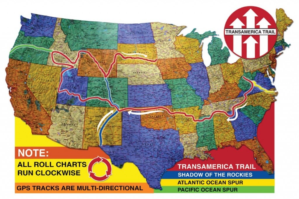
Image from TransAMTrack.com
There are four routes of the TAT — the main Trans-America Trail and 3 spur routes. The 3 side routes are the Shadow of the Rockies, the Atlantic Ocean Spur, and the Pacific Ocean spur. The spurs add more overlanding miles and opportunities to explore great American landscapes.
TAT overlanders can choose their starting point anywhere along the route. However, drivers should know that the Trans-America Trail, maps, and roll charts were specifically designed to navigate from East to West.
The routes are both practical and scenic. Sam’s thoughtful planning showcases the beauty of our wildlands while taking the guesswork out of finding a place to rest. This means you can choose to sleep under the stars by camping or you can settle into something a little more comfortable at one of his lodging recommendations.
Unfortunately, Sam’s maps and roll charts do not include campgrounds, state parks, or national parks. Don’t worry though, there are endless camping options along the way.
Find free campgrounds from your car without WiFi. The Dyrt PRO lets you download maps and campgrounds without cell service. “My alternative to using pro would be to drive back out to cell service.”
The Main Route of the Trans-America Trail
The main route of the Trans-America Trail takes in a huge variety of terrain and landscapes. The TAT begins in West Virginia and heads into Georgia before it turns and heads west. Near the Utah-Nevada border the trail goes north towards Idaho and then cuts back east through Wyoming and South Dakota.
The TAT takes drivers through and near many of our great national parks. Here are the National Parks closest to the main route:
- Great Smoky Mountains National Park
- Great Sand Dunes National Park
- Canyonlands National Park
- Arches National Park
- Capitol Reef National Park
- Great Basin National Park
- Yellowstone National Park
- Grand Teton National Park
- Wind Cave National Park
- Badlands National Park
Shadow of the Rockies Spur
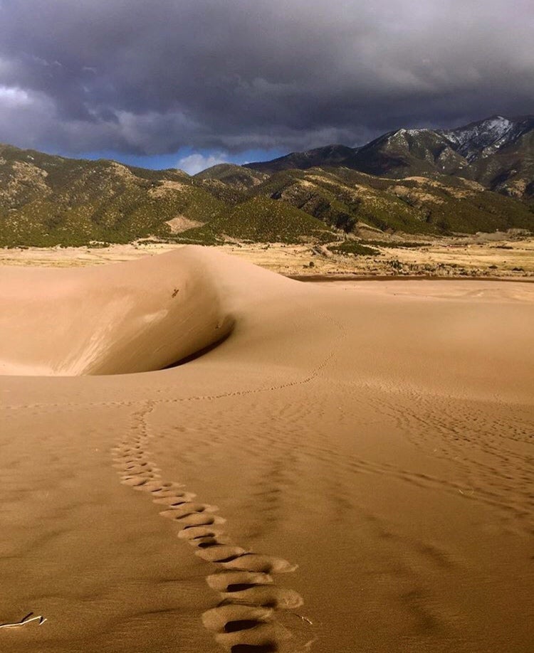
Great Sand Dunes National Park // Image from The Dyrt camper Alicia V.
The Shadow of the Rockies spur begins just outside of El Paso, Texas and heads north crossing the TAT at the northern New Mexico border and reconnecting the the TAT at the Wyoming-Colorado border.
It should be no surprise that the Shadow of the Rockies route is a very rocky one. After leaving the popular ghost town of St. Elmo, this spur takes overlanders over the infamous Tin Cup Pass.
This challenging rocky pass is one of the highest mountain roads in Colorado. Riders have the option to skip this section of technical terrain. Sam provided an alternate route to bypass Tin Cup Pass by going through Buena Vista and Cottonwood Pass.
This spur offers travelers the chance to make a side trip to the continental divide and visit Rocky Mountain National Park. Visit the tallest sand dunes in North America and explore the unique terrain of the nearby Great Sand Dunes National Park.
Atlantic Ocean Spur
At 469 miles, the Atlantic Ocean Spur (AOS) is the shortest of the 3 spurs. Riders can ride from Nags Head on the outer banks of the Atlantic through Shenandoah National Park into Burnsville, Virginia.
Due to the densely populated east coast, the first half of this spur is pavement. The second half more than makes up for it with beautiful winding roads through rural countryside and lush forests. Riders are sure to enjoy taking in the rolling mountain views of the Blue Ridge Mountains.
Pacific Ocean Spur
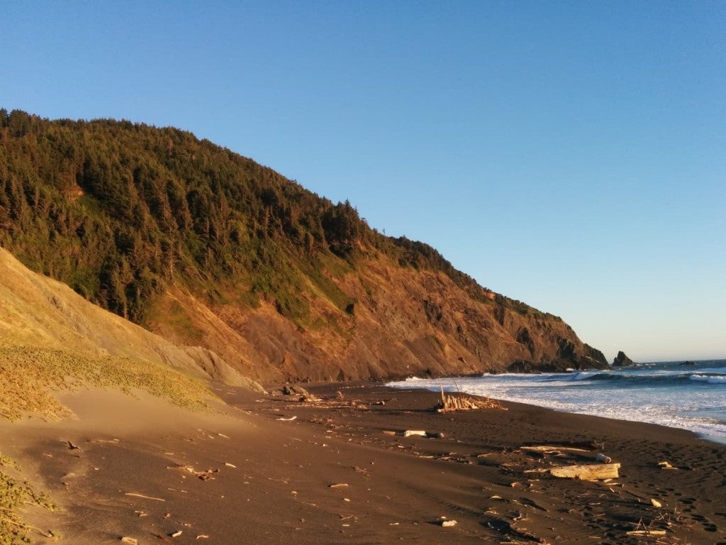
The Oregon Coast at Humbug Mountain State Park near Port Orford // Image from The Dyrt camper Jesse H.
This 800-mile spur takes riders from the TAT all the way to the Pacific Ocean. The side-route leaves the TAT in Emmett, Idaho and takes drivers across Oregon to Port Orford on the coast. This section of trail showcases the lush green beauty of the Pacific Northwest.
Due to the remote nature of much of this section, it is recommended that you monitor your fuel and water carefully. Oregon’s many national forests and public lands offer ample camping opportunities.
This short spur doesn’t get as close to national parks as the other routes. However, if you don’t mind a few more miles behind the wheel you can visit two Pacific Northwest gems — Crater Lake National Park and The Redwoods.
Related Articles:
The Dyrt is the only camping app with all of the public and private campgrounds, RV parks, and free camping locations in the United States. Download now for iOS and Android.Popular Articles:
Articles on The Dyrt Magazine may contain links to affiliate websites. The Dyrt receives an affiliate commission for any purchases made by using such links at no additional cost to you the consumer.