The stretch of Route 66 from Amarillo, Texas to Kingman, Arizona showcases the American Southwest’s dramatic transition from open plains to high desert plateaus. This segment spans about 750 miles and crosses three states, linking Texas’s wide-open panhandle with New Mexico’s mesas and Arizona’s red rock country. It’s a journey filled with classic roadside Americana, expansive desert vistas, ancient pueblos, and mountain forests. Travelers can spray-paint cars at a famous art installation, stand on the Mother Road’s midpoint, explore petrified woodlands, and camp under pines at 7,000 feet elevation – all in a four-day drive. The route is drivable by standard vehicles and RVs, with most of the path following I-40 and well-marked historic alignments. Late spring and early fall offer the best weather, but careful planning can make any season enjoyable. This guide provides a day-by-day itinerary, top attractions, camping recommendations, and practical tips to help you experience this portion of the Mother Road like a knowledgeable friend. (For a big-picture plan of the entire trip, see our complete Route 66 road trip guide.)
Segment Overview
Route Description: The Amarillo-to-Kingman segment of Route 66 covers roughly 750 miles of the “Mother Road,” cutting across the Texas Panhandle, the width of New Mexico, and into western Arizona. It begins amid Texas plains and cattle country, passes through neon-lit small towns in New Mexico, and climbs onto the Continental Divide before descending toward the deserts and pine forests of Arizona. Much of the drive shadows modern I-40, but plenty of historic 66 spurs remain accessible for those who want the authentic experience. From Amarillo’s famous Cadillac Ranch to the midpoint in Adrian, from Tucumcari’s glowing motel signs to the ancient petrified logs of Arizona, this segment is packed with variety.
What Makes it Special: This part of Route 66 offers a greatest-hits of Southwestern Americana. You’ll see kitschy roadside attractions (like vintage motels and giant sculptures) alongside incredible natural wonders. New Mexico’s portion is the longest in any state and contains preserved pre-interstate road sections and cultural treasures like Acoma Pueblo. Arizona’s stretch includes iconic sites such as Petrified Forest National Park, Meteor Crater, and towns like Winslow and Seligman where Route 66 nostalgia thrives. By the time you reach Kingman, you’ll have traveled from flat ranchland up to high desert and back down to rugged canyons. The region’s mix of history, scenery, and quirky charm encapsulates why Route 66 remains a legendary drive.
Travel Considerations: Plan for about four days to fully enjoy this segment. Daily drives range from ~120 to 285 miles, which leaves time for stops. Services are regular in Texas and central New Mexico, but distances between towns grow in western Arizona. Summer brings intense heat often topping 100°F, so carry water and watch your engine temperature. Spring winds in the Panhandle can be strong, and winter storms can dust the higher elevations around Flagstaff with snow. Arizona does not observe daylight savings, meaning the time can jump an hour when crossing the NM/AZ state line depending on the season. Cell coverage is decent along I-40, but it fades in rural stretches – downloading offline maps is wise. With a flexible mindset and a readiness for adventure, this segment is a highlight of any full Route 66 road trip itinerary.
Quick Stats
| Segment Distance | ~750 miles (1207 km) |
| States Covered | Texas, New Mexico, Arizona |
| Suggested Duration | 4 days (with sightseeing stops) |
| Major Stops | Amarillo – Tucumcari – Albuquerque – Gallup – Flagstaff – Kingman |
| Best Seasons | May–June and Sept–Oct (mild weather) |
| Route Profile | Paved highways (I-40) with optional historic 66 alignments |
| Highlights | Cadillac Ranch, Midpoint in Adrian, Neon in Tucumcari, Petrified Forest NP, Meteor Crater, Seligman historic highway |
Day-by-Day Suggestions
Day 1: Amarillo, TX to Albuquerque, NM (285 miles, ~4.5 hours)
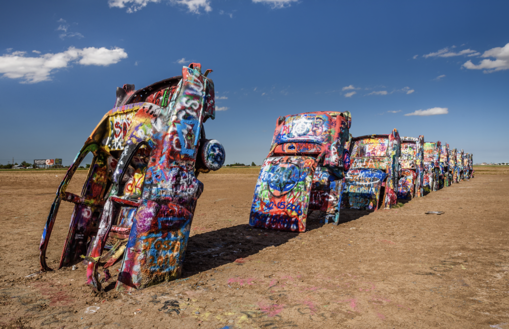
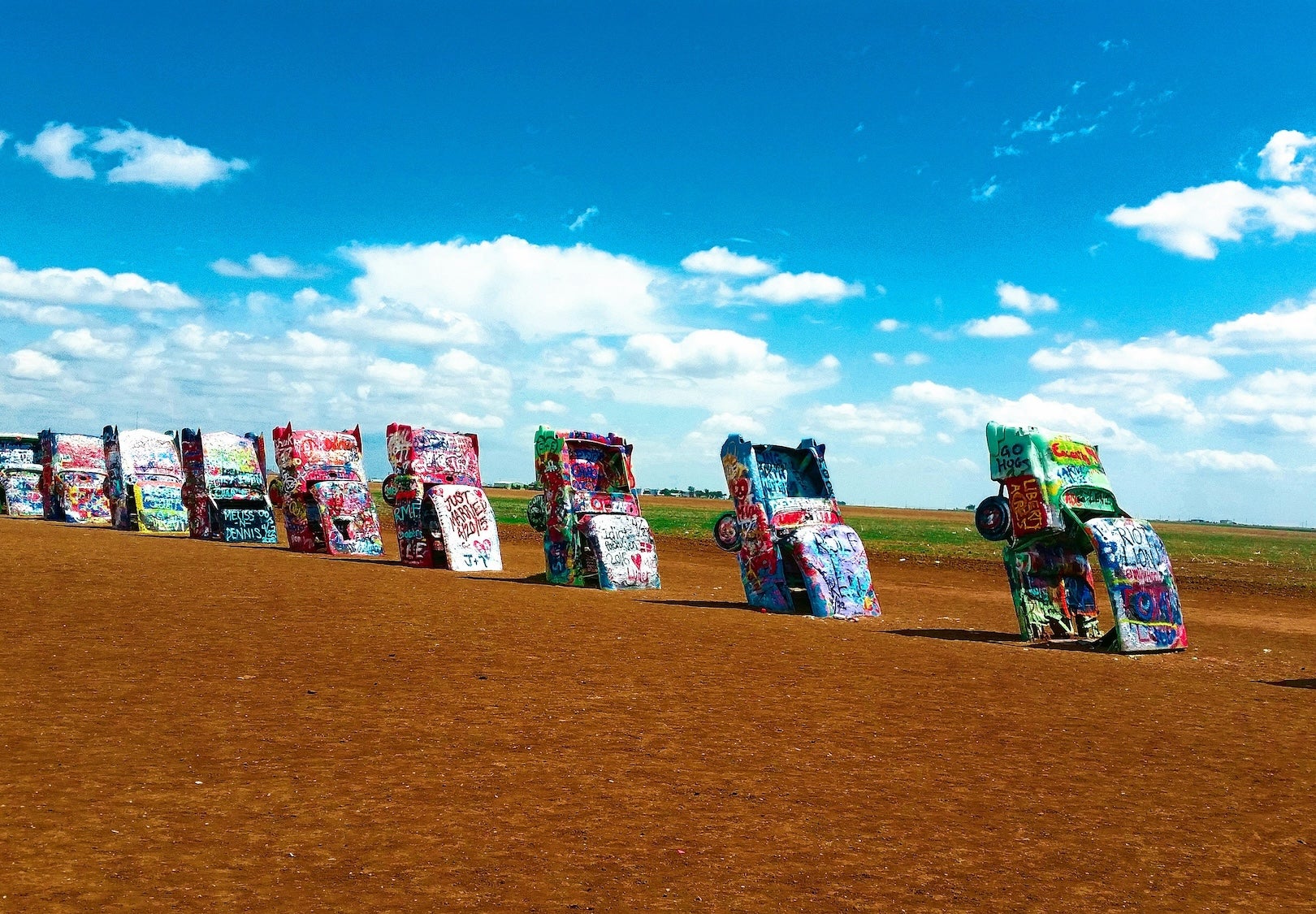
Morning: Start in Amarillo by visiting Cadillac Ranch on the western outskirts of town. This iconic art installation features ten classic cars buried nose-down in a field, free for visitors to spray paint and make their mark. It’s best seen in the morning light – plus you’ll beat the midday crowds. After getting your fill of neon graffiti at Cadillac Ranch, cruise Amarillo’s 6th Avenue Historic District (old Route 66) for a look at retro diners and shops. Fuel up here, as the next stretch is rural. Heading west, you’ll cross flat rangeland dotted with windmills. Stop in Adrian, Texas at the Midpoint Cafe, a classic diner exactly at Route 66’s geographic midpoint between Chicago and Santa Monica. A sign marks the halfway point – a great photo op and chance to grab a piece of their famous pie. Just past Adrian, you’ll enter New Mexico at the ghost town of Glenrio. Take the exit for the vintage Route 66 alignment through Glenrio if you want to see the remnants of old motels and gas stations straddling the TX/NM line.
Afternoon: Continue west into New Mexico’s wide-open plains. Soon you’ll reach Tucumcari, a small city once known for having “2000 motel rooms.” Cruise Tucumcari’s main drag to admire the multitude of restored mid-century motel signs and murals – the town is covered in neon signs and historic motels. Notable spots include the Blue Swallow Motel (famous for its glowing blue neon and garages by each room) and Tee Pee Curios shop. Consider a quick lunch at a local diner like Del’s before getting back on I-40. As you drive on, watch for billboards of roadside attractions – classic Route 66 kitsch. In Santa Rosa, a worthwhile detour is the Blue Hole, a spring-fed pool with astonishingly clear, blue water. It’s 80 feet deep and a popular scuba training site in the desert. You can take a dip or just enjoy the view; the water stays a brisk 61°F year-round. Back on the road, note that Santa Rosa has several gas stations and grocery stores – a good resupply point with steady access to food and fuel. From here, it’s about 115 miles to Albuquerque. The landscape shifts to red mesas and distant buttes as you pass through Laguna and Acoma territories. As you approach Albuquerque, you’ll descend from high plains into the Rio Grande Valley with the Sandia Mountains looming to the east.
Evening: Arrive in Albuquerque, the largest city in New Mexico, by early evening. Central Avenue is old Route 66 – consider driving a stretch of it through downtown to see vintage neon signs like the buzzing moniker of the El Vado Motel or the kitschy Route 66 Diner. Albuquerque offers every service you might need: top off your tank here, and if you need outdoor gear or groceries, there are plenty of options. For dinner, try some New Mexican cuisine (red or green chile on everything!). Frontier Restaurant near the University or Little Anita’s in Old Town are traveler favorites for local flavor. Campers can head west of the city to settle in at the Route 66 RV Resort on Laguna Pueblo just outside Albuquerque. This modern RV park has large concrete pads, full hookups, and clean facilities – reviewers praise it for comfort and convenience to the city. If you prefer to stay in town for nightlife, Albuquerque also has private campgrounds and numerous hotels. Either way, enjoy a night’s rest at a lower elevation (~5,000 ft) before climbing back into the high desert tomorrow.
Day 2: Albuquerque, NM to Gallup, NM (138 miles, ~2 hours)
Morning: Take it slow this morning – Day 2’s drive is shorter, giving you time to explore. If you’re an early riser, you might drive a few minutes to Petroglyph National Monument on Albuquerque’s west side for a short hike among ancient rock carvings before hitting the highway. As you depart Albuquerque, consider a detour at Exit 102 to visit Acoma Pueblo (Sky City), about 15 miles south of I-40. Acoma Pueblo sits atop a 367-foot sandstone mesa and is one of the oldest continuously inhabited communities in North America (dating back over a thousand years). Guided tours are available at the Sky City Cultural Center, offering insight into Acoma’s rich history and stunning views of the surrounding desert. If you go, plan ~2 hours for the round-trip and tour – it’s a profound cultural experience well worth the time. Back on I-40, continue west past Grants. You’re now near the Continental Divide; the highway crests around 7,200 feet in elevation in this area. Keep an eye out for the small Continental Divide signage. This high desert section can be windy, and you may notice the air is thinner – stay hydrated and don’t over-exert yourself.
Afternoon: Around lunchtime, you’ll reach Gallup, New Mexico, a historic railroad and trading post town near the Arizona border. On the way in, you can stop at Red Rock Park (Exit 26) for a picnic or short hike among towering red sandstone cliffs. The park’s campground is nestled beneath the cliffs and is known for its beautiful, unique location with electric hookups and warm showers – a nice spot if you’re ready for an overnight, though pushing to Gallup proper gives you more dining options. In Gallup, explore the downtown strip which still carries a rugged Old West vibe. The historic El Rancho Hotel on old Route 66 is famous for hosting Hollywood movie stars in the 1940s-50s – its lobby is like a museum of western memorabilia. You can grab lunch in El Rancho’s 49er Lounge or at a local Navajo taco stand. Gallup is also renowned for Native American jewelry and crafts; consider browsing Richardson’s Trading Post or others for authentic Navajo and Zuni silverwork. Fuel up here if you’re low – it’s the last major town before Arizona. If time permits, the Gallup Cultural Center (in the restored train depot) offers exhibits on regional Native culture and the history of Route 66 in Gallup.
Evening: Stay overnight in Gallup or nearby. Gallup has several private RV parks and basic campgrounds; just east of town, the Red Rock Park & Campground (in Church Rock) is a scenic choice, set against stunning red rock formations. Campers appreciate the warm showers and unique views, though some sites are close together. Another option is Bluewater Lake State Park, about 30 miles back east near Prewitt, if you’d rather camp by a lake – it’s quieter but will add a bit of backtracking. In Gallup itself, you’ll find plenty of motels if you need a night off from camping. For dinner, you can’t go wrong with authentic New Mexican or Mexican food – try Jerry’s Cafe (a local staple for enchiladas) or head to Coal Avenue for newer breweries and cafes. Enjoy the starry sky – Gallup’s high desert location makes for brilliant night skies when the weather is clear.
Optional stargazing add on: If you have an extra night and want a true dark sky stop, Cosmic Campground in the Gila National Forest is one of the best places in the Southwest to see the Milky Way. It is a detour south of the Route 66 corridor, but the payoff is silence, zero light pollution, and unreal night skies. Plan for extra driving time, bring everything you need, and treat it as a bonus night rather than a quick stop.
Day 3: Gallup, NM to Flagstaff, AZ (185 miles, ~3 hours)
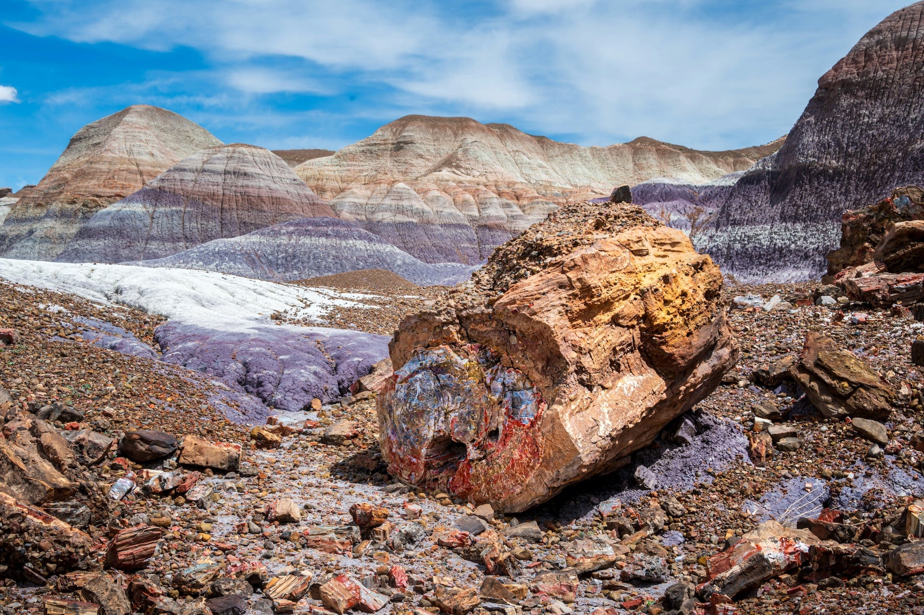
Morning: Prepare for a day packed with natural wonders. As you leave Gallup, you’ll enter Arizona – note that if it’s summer, the clock will shift back one hour (Arizona does not observe Daylight Savings Time). Just 25 miles west of Gallup, take Exit 311 for Petrified Forest National Park and the Painted Desert. This national park sits directly on Historic Route 66, and it’s a must-see. Start at the Painted Desert Visitor Center (north end) to learn about the vibrant badlands before driving the 28-mile park road south. Along the way, you’ll encounter overlooks with sweeping multicolored desert vistas, petrified wood fields, and historic sites. Don’t miss the short walk to Newspaper Rock (to see ancient petroglyphs) and the pull-off where an old 1932 Studebaker marks the original Route 66 alignment through the park. Towards the south end, you can take a brief hike at the Crystal Forest or Giant Logs trail to get up close with the fossilized logs – some over 200 million years old. It’s surreal to see stone logs in rainbow hues strewn across the desert. A full drive-through can take 2-3 hours with stops. Petrified Forest has no campground, so by late morning, exit near the town of Holbrook.
Afternoon: Holbrook is a classic Route 66 town in eastern Arizona. Consider grabbing lunch here – perhaps at Joe & Aggie’s Café, an old-school diner known for Navajo tacos and Route 66 vibes. For a kitschy photo, stop by the Wigwam Motel where vintage cars are parked in front of concrete teepee rooms (it’s one of the few surviving “wigwam villages” from Route 66’s heyday). Continuing west, a worthwhile detour awaits about 20 miles further: Meteor Crater. Signposted from I-40 (Exit 233), Meteor Crater is a giant meteor impact site nearly a mile wide and 550 feet deep, formed 50,000 years ago. It’s a worthwhile detour near Winslow to witness this otherworldly crater. The privately-run visitor center offers impressive viewing platforms and geology exhibits (plan ~1 hour, and note there’s an admission fee). Back on Route 66, you’ll pass through Winslow, Arizona, made famous by the Eagles’ song “Take It Easy.” A quick stop at the “Standin’ on the Corner” park downtown is pure Americana – there’s a bronze statue and flatbed Ford marking the spot, surrounded by murals and 70s music vibes. If you need supplies, Winslow has gas, grocery, and a couple of RV parks. Just outside town, you’ll also find Homolovi State Park, which preserves ancestral Hopi ruins. The state park’s campground is highly rated for its spacious sites with electric hookups and clean showers – a great overnight option if you want a quieter night sky away from the interstate.
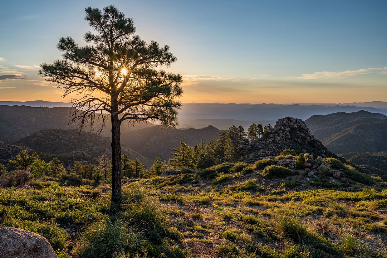
Evening: Pressing on, you’ll climb gradually toward Flagstaff. The terrain changes as you gain elevation – scrubland gives way to pinyon junipers, then tall ponderosa pines. You’re entering the Coconino National Forest and nearing 7,000 feet above sea level, so the air will be cooler and scented with pine. Flagstaff is a vibrant mountain city and a welcome stop after a long day. Before settling in, you might take a short detour on U.S. 89 north of town (~12 miles) to visit Sunset Crater Volcano National Monument and Wupatki National Monument, or simply appreciate the San Francisco Peaks looming over Flagstaff (Humphreys Peak, at 12,633 ft, is Arizona’s highest point). Flagstaff has ample services: refuel and restock at the many gas stations, supermarkets, or even outdoor outfitters if needed. For camping, a popular choice is the Bonito Campground near Sunset Crater, about 14 miles north of downtown. Bonito sits among ponderosa pines and offers a peaceful, rustic setting (no hookups or showers) with generous spacing between sites. Campers love the dark, quiet nights for stargazing. Alternatively, the Flagstaff KOA on the east side of town provides more amenities (showers, hookups, even cabins) if you’re looking for convenience. If you prefer not to camp tonight, Flagstaff has plenty of motels and lodges – this area was a major stop on 66, after all. Treat yourself to dinner and a local brew downtown; Flagstaff’s walkable historic district has several craft breweries and eateries. It’s a college town (home to Northern Arizona University), so there’s a youthful energy. Enjoy the evening air – even in summer, nights here can be crisp and cool, a nice change from the desert heat earlier in the trip.
Optional detour for canyon views and culture: If you have an extra day and want to trade roadside kitsch for something quieter and more profound, detour north to Navajo National Monument. Canyon View Campground sits right on the rim, with big open views and a calm, high desert feel at night. It is well off the Route 66 line, so it only makes sense if you are building in extra time, but it is a memorable way to experience the landscape and history of this region beyond the interstate.
Day 4: Flagstaff, AZ to Kingman, AZ (150 miles, ~2.5 hours)
Morning: Today’s drive winds through the heart of historic Route 66 in Arizona. From Flagstaff, head west on I-40 about 30 miles to Williams, a charming mountain town at the base of Bill Williams Mountain. Williams was the last town on the entire Route 66 to be bypassed by the interstate (in 1984) and retains a strong Route 66 atmosphere. Take exit 163 into Williams’ downtown and you’ll find a strip of classic motels, diners, and shops decked out in 1950s flair. This is also a gateway to the Grand Canyon – the Grand Canyon Railway departs from Williams to the South Rim, and many travelers detour north from here for a day at the canyon (if you have an extra day, it’s a highly recommended side trip). Assuming you stay on Route 66, continue west toward Ash Fork. You can choose to hop on the longest continuous preserved stretch of old Route 66 here: from just past Seligman all the way to Kingman, the original two-lane road rolls through the high desert. Seligman (exit 123 from I-40) is a must-stop small town that proudly calls itself the “Birthplace of Route 66.” Here, in the late 1980s, barber Angel Delgadillo led efforts to revive the road’s legacy when it was at risk of being forgotten. Stroll down Seligman’s main street to see whimsical businesses like the Snow Cap Drive-In (famous for its ice cream and practical jokes) and gift shops overflowing with Route 66 memorabilia. The vibe is fun and nostalgic. Be sure to fuel up in Seligman if you plan to drive the Oatman Highway route, as services are sparse on the old road. From Seligman, Historic Route 66 (which doubles as AZ-66) veers away from the interstate and you can follow it for a classic ride.
Afternoon: The 87-mile journey from Seligman to Kingman on historic Route 66 is a highlight for enthusiasts. This highway features several stretches of original concrete and takes you through tiny outposts frozen in time. You’ll traverse wide grasslands and see the landscape gradually become more arid. Keep an eye out for Burma-Shave style rhyming billboards along the shoulder – a nod to mid-century road culture. About 28 miles west of Seligman, you’ll pass through Peach Springs, located on the Hualapai Indian Reservation. Peach Springs has a gas station, a café, and it’s the gateway to Grand Canyon West. It’s also known from the Disney-Pixar movie Cars (the fictional Radiator Springs drew some inspiration from these parts). As you continue, look for the Hackberry General Store – a ramshackle but photogenic stop filled with retro signs, old cars, and cold sodas waiting inside. From Hackberry, the blacktop winds between rugged golden hills and dry river washes as you approach Kingman. Take it slow and enjoy the drive – you’re literally riding on history here, as this portion is one of the best-preserved segments of 66. There are few other vehicles, and you can almost imagine the stream of 1930s migrants or 1950s vacationers who traveled this same road.
Evening: Roll into Kingman, Arizona, by late afternoon. Kingman sits in a broad valley surrounded by low mountains and marks the end of this segment. Before you settle down, consider visiting the Arizona Route 66 Museum at the historic Powerhouse building downtown. It’s an excellent exhibit covering the Dust Bowl migration and the golden age of Route 66 travel, complete with vintage automobiles and narratives. Also check out the 1907 steam locomotive on display across the street – a tribute to Kingman’s rail history. Downtown Kingman has a handful of classic diners; grab a hearty meal at Mr. D’z Route 66 Diner (you can’t miss its pink-and-teal exterior) or Floyd & Company for BBQ. As for your final night’s stay, one fantastic camping option is just 12 miles outside town up in the Hualapai Mountains. The Hualapai Mountain Park campground sits around 6,500–7,000 feet elevation in a pine and oak forest. It’s a refreshing change from the desert heat – many travelers love the cool temperatures and chances to spot wildlife like deer after days of warmer terrain. The campground offers tent sites, RV sites, and cabins, plus showers and water, making it easy to relax. One reviewer noted how dark and quiet it gets at night – perfect for stargazing and a good night’s sleep. If you prefer to stay in town, Kingman has multiple RV parks and motels as well. Either way, you’ve earned a restful evening. Enjoy the sunset as it casts a glow on the surrounding mesas – tomorrow, the road west heads into the Mojave Desert, so savor the relative greenery while you can. By completing the Amarillo to Kingman segment, you’ve traversed an incredible variety of landscapes and history. Give yourself a pat on the back, perhaps with a locally brewed Black Bridge beer or a slice of pie, and get ready for the adventures that lie beyond Kingman on Route 66’s final push to the Pacific.
Campgrounds to Consider
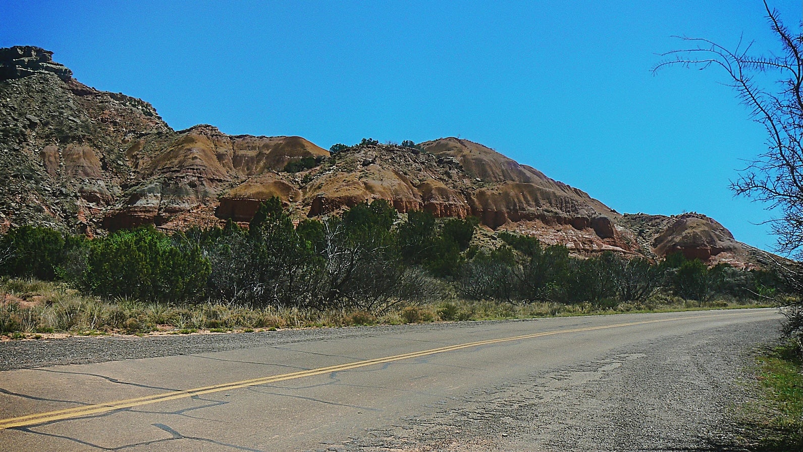
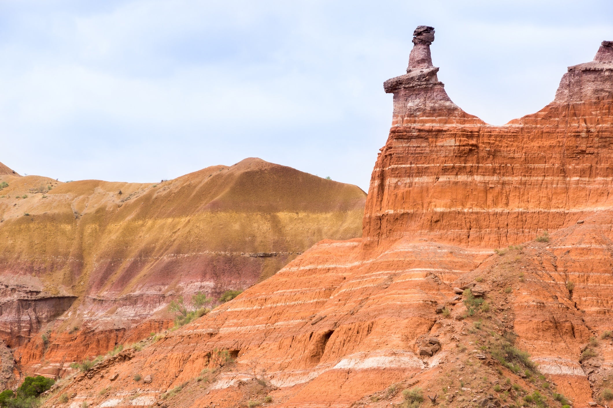
Palo Duro Canyon State Park – near Amarillo, TX: Tucked about 30 miles south of Amarillo, this state park lets you camp inside “the Grand Canyon of Texas.” Multiple campgrounds (like Hackberry, Juniper, Mesquite) sit at the canyon floor among stunning red rock cliffs and hoodoos. Sites have water and electric hookups, picnic tables, and access to showers. Early reservations are advised, especially for RV-friendly spots, as Palo Duro is extremely popular (The Dyrt community even ranked it among the top campgrounds in the U.S.). Campers love the miles of hiking and biking trails that depart near the sites – you can explore colorful canyon scenery by day, then enjoy quiet, star-filled nights. Summer brings very hot days on the canyon floor, so plan hikes for early morning or evening and take advantage of shade where you can. Wildlife like turkeys, road runners, and even wild bison (in a separate park section) can sometimes be spotted. Palo Duro’s campgrounds are well-maintained, and rangers frequently patrol, adding a feeling of safety. Staying here is a fantastic way to kick off your Route 66 trip with a taste of the great outdoors beyond the road.
Route 66 RV Resort – Albuquerque, NM: This modern RV resort is conveniently located just west of Albuquerque on Laguna Pueblo land. It’s an ideal overnight if you want easy access to city attractions while enjoying a comfortable campground. The resort offers spacious pull-through sites on level concrete pads, full 30/50-amp hookups, a dump station, and immaculate facilities. Campers consistently praise the cleanliness of the bathrooms and showers (“some of the best around,” according to one reviewer) and the amenities like a heated pool, hot tub, clubhouse, and even a small casino next door. Pets are welcome, and there are fenced dog run areas to let them stretch their legs. Many sites are well separated, providing a bit of privacy and great views of the desert sunsets. Being only 14 minutes from downtown Albuquerque, it’s a perfect base to explore the city’s museums or Old Town, then retreat for a peaceful night. Free Wi-Fi, laundry facilities, and daily trash pickup add to the convenience. If you’re road-tripping in a big rig, the wide drives and long pads here make maneuvering easy – it’s very big-rig friendly. Overall, Route 66 RV Resort combines the nostalgic location (right off Historic 66/I-40) with all the comforts a traveler could want.
Bluewater Lake State Park Campground – Prewitt, NM: Roughly halfway between Albuquerque and the Arizona line, Bluewater Lake State Park offers a tranquil lakeside camping experience in the high desert. The campground, at about 7,400 feet elevation, sits on the shores of Bluewater Lake with views of surrounding bluffs. Expect a mix of developed sites (some with electric hookups) and more primitive spots, spread across several loops like Pinon Cliff and Lakeside. Facilities include clean restrooms, drinking water, and showers, making for a comfortable stay. Campers highlight the natural beauty here – tall juniper and pinon trees provide shade at many sites, and wild horses are often seen roaming the area! You can hike easy trails along the lake or even try your hand at fishing (the lake is stocked with trout and tiger muskies). Come evening, the atmosphere is peaceful and quiet, especially on weekdays. Do note that due to its elevation, Bluewater can get windy and chilly at night, even in summer (bring layers). The park is open year-round, but some loops or facilities may close seasonally (usually winter). For Route 66 travelers, Bluewater Lake is a great place to escape the freeway for a night and enjoy a campfire with a stunning lake view (as one reviewer put it). It’s located about 4 miles south of I-40 (Exit 63) on a paved road – a short detour for a big reward in scenery and serenity.
Red Rock Park & Campground – Gallup (Church Rock), NM: Just east of Gallup, this public campground sits amid dramatic red sandstone cliffs and offers a unique overnight experience for Route 66 travelers. The park features both tent and RV sites, some with water/electric hookups. Waking up here is memorable – the sun paints the canyon walls in brilliant reds and oranges. Campers appreciate the clean bathrooms with hot showers and flush toilets (a welcome comfort after a dusty day on the road). There’s also a small museum and trading post at the park entrance. Hiking trails lead from the campground into the rocks; even a short stroll will yield great views. Sites are mostly gravel and can accommodate large RVs, though a few visitors note that the layout means some sites are closely spaced. Still, the consensus is that the scenery compensates for any lack of privacy. One camper’s review summed it up: “Beautiful, unique location – worth the stop for the night.” Red Rock Park is also known for the annual Red Rock Balloon Rally each December, when dozens of hot air balloons launch against the cliffs (if your timing aligns, it’s a spectacular sight). Even on a normal night, you’ll likely have a quiet stay; it’s away from city noise and the sky is dark. This campground is a convenient and picturesque option if you plan to overnight near Gallup rather than pressing on into Arizona.
Homolovi State Park Campground – Winslow, AZ: Located just 5 miles north of Winslow, Homolovi State Park is a hidden gem for campers interested in both history and comfort. The park protects the archaeological remains of Homol’ovi villages (ancestral Hopi pueblos), and its campground provides an excellent base to explore them. The campground has 53 spacious sites, all paved and mostly level, with electric and water hookups at most sites – great for RVs or tent campers who appreciate amenities. Reviewers frequently praise the cleanliness of the facilities: bathrooms and hot showers are well-maintained and much appreciated after a day of dusty sightseeing. At each site you’ll find a picnic table and fire ring, and while vegetation is sparse (expect desert shrubs, not big trees), the sites are well spaced for privacy. By late afternoon, you might take the short trails to view petroglyphs or the two pueblo ruins in the park; it’s a unique feeling to watch the sunset over the high desert knowing people lived here centuries ago. Homolovi is also known for its night skies – far from big city lights, the stargazing is excellent on clear nights. Winslow is a quick drive if you want to pop into town to stand on the famous corner or grab supplies. Overall, Homolovi State Park Campground is a solid spot for those looking to soak in some history and enjoy the great outdoors. It’s quiet, safe, and scenic – an ideal respite along the Mother Road.
Bonito Campground – Sunset Crater area (Flagstaff), AZ: If you’re craving a cooler, woodsy camping experience after days of desert, Bonito Campground delivers. Set within Coconino National Forest at ~6900 ft elevation and adjacent to Sunset Crater Volcano National Monument, Bonito is about 15 miles north of downtown Flagstaff. It operates seasonally (generally May through mid-October) and is first-come, first-served. The campground’s 44 sites are nestled among tall ponderosa pines and ancient lava flows, lending a distinct atmosphere. Campsites are generously spaced – one camper noted you feel like you have a place to yourself. While there are no showers or hookups (it’s more of a rustic camping experience), there are flush toilets, potable water, picnic tables, and fire rings, and the roads are paved for easy access. By day, you can hike the Lava Flow Trail across the road at Sunset Crater or drive a little further to see the Native American ruins at Wupatki National Monument. By night, Bonito lives up to its name (which means “pretty”): it’s quiet, cool, and often perfumed with the scent of pines. The lack of urban light pollution makes for great star viewing. Families and tent campers love the peaceful vibe here, and RV campers (small-to-medium rigs fit fine) appreciate the beauty, though they have to forego hookups. Bonito is a fantastic choice if you want a true “camping in nature” night on your Route 66 journey, while still being relatively close to town. Just remember to bring warm layers – nights can get chilly, even in summer, at this altitude.
Hualapai Mountain Park – Kingman, AZ: A favorite among Route 66 road-trippers, Hualapai Mountain Park offers a cool alpine retreat in the midst of the Arizona desert. About 20 minutes (11 miles) southeast of Kingman, this county park is perched in the Hualapai Mountains at 6,500-8,000 feet elevation. The drive up is curvy but paved, climbing from sagebrush into ponderosa pines and boulder-strewn hills. The park features several camp areas and cabins spread out in the forest. Sites range from tent-only spots tucked among junipers to RV sites with picnic tables and charcoal grills. Amenities include drinking water, restrooms with flush toilets, hot showers, and even a small camp store at the ranger station. No hookups are available, but there is a dump station for RVs. What people love most is the climate – it might be 100°F in Kingman, but up here it could be in the comfortable 70s. It’s high-elevation forest camping with cool air and pine shade, making it a perfect break from the heat before heading into the Mojave. Wildlife is abundant; you’re likely to see mule deer wandering near your site and hear woodpeckers in the mornings. The park has a network of hiking trails leading to scenic overlooks (try the trail up to Hualapai Mountain Peak for a panoramic view). At night, things get very quiet and dark (note: some campers mention that larger RVs need to take it slow on the access road and tight turns, but they do make it up). If you prefer a roof, the park’s rustic cabins are an option, but they book up early. All in all, camping at Hualapai Mountain Park is a refreshing finale for this segment – as one reviewer said, “whether you’re looking for a peaceful retreat or an adventure-filled getaway, Hualapai Mountain Park has plenty to offer.” It’s a hidden oasis that might tempt you to stay an extra day.
Top Activities & Attractions
Roadside Icons & Route 66 Landmarks
Cadillac Ranch (Amarillo, TX): This quirky and world-famous art installation features 10 vintage Cadillac cars buried nose-first in a row. Visitors are encouraged to bring spray paint and add their own artistic touch to the ever-changing graffiti layers on the cars. It’s an Instagram paradise and a tangible symbol of Route 66’s free-spirited, grassroots art culture. Best of all, it’s free and open 24/7 in a cow pasture off I-40 – just park on the frontage road and walk right up. Tip: bring a can of bright paint (or find leftovers on the ground) and make some memories on metal.
Midpoint Sign & Café (Adrian, TX): At Adrian you’ll find the exact midpoint of Route 66, 1,139 miles from both Chicago and Los Angeles. A roadside sign marks the spot, providing a classic photo opportunity. Across the road, the Midpoint Café has served travelers since the 1950s – it’s famed for homestyle cooking and “ugly crust” pies. Stopping here, you truly feel the camaraderie of the Route 66 community, as travelers heading east or west converge at the halfway point to swap stories and encouragement.
Tucumcari Neon & Murals (Tucumcari, NM): Tucumcari is a small town that looms large in Route 66 lore for its neon glory. In the evenings, a drive down the main strip (Route 66 Blvd) is like stepping back to 1960 – classic motels like the Blue Swallow and the Motel Safari light up in electric blue and pink. The town’s motto “Tucumcari Tonite!” harks back to when hundreds of road-weary travelers would aim to stop here for the night. By day, check out the large street murals depicting Route 66 history. Don’t miss the New Mexico Route 66 Museum at the Convention Center or the Tee Pee Curios shop (with a teepee-shaped entrance) for souvenirs. Tucumcari’s neon scene is a prime example of how the town is covered in neon signs and historic motels – it’s a living Route 66 postcard.
Standin’ on the Corner Park (Winslow, AZ): A tribute to the Eagles’ famous song “Take It Easy,” this corner in downtown Winslow has become a fun pilgrimage for music and road trip fans. A bronze statue of a troubadour with a guitar stands in front of a mural that includes the reflection of a “girl, my Lord, in a flatbed Ford.” There’s even a red flatbed Ford truck parked permanently at the site. The park is corny in the best way, and it revitalized Winslow’s downtown when it was installed. It’s free to visit any time, and there’s usually someone strumming an Eagles tune nearby. Across the street, vendors sell Route 66 and Eagles-themed souvenirs. It’s a quick stop that invariably puts a smile on people’s faces – and yes, you’ll probably have that song pleasantly stuck in your head afterward.
Seligman Historic District (Seligman, AZ): Often considered the birthplace of Route 66’s modern resurgence, Seligman is a tiny town with a huge personality. Take a stroll down Railroad Avenue/Route 66 in Seligman to soak up the deliberate kitsch. Delgadillo’s Snow Cap Drive-In is a must – originally opened in 1953 by prankster Juan Delgadillo, it’s still run by his family who carry on the tradition of friendly jokes while serving burgers and shakes. Across the street, Juan’s brother Angel Delgadillo’s old barber shop is now a Route 66 gift shop; Angel was instrumental in getting Arizona to designate Route 66 a historic highway in 1987, sparking preservation efforts. The town is filled with vintage cars on display, mannequins, old signs, and murals. It can feel a bit touristy, but it’s genuine in its celebration of Route 66 culture. If you loved the Pixar movie Cars, you’ll recognize elements of Seligman that inspired the fictional Radiator Springs (for instance, the characters of Fillmore and Stanley have roots here). Seligman is also where you can hop onto the longest remaining uninterrupted stretch of Route 66. It’s a living time capsule and a testament to the people who refused to let Route 66 die.
Natural Wonders & Outdoor Stops
Blue Hole of Santa Rosa (NM): Just a mile off old Route 66 in Santa Rosa sits a true oasis – the Blue Hole. This circular spring is approximately 60 feet across and 80 feet deep, with crystal-clear turquoise water that maintains about 61°F year-round. Surrounded by desert, it’s a surreal sight. You can swim or cliff-jump (free, with a modest fee for parking) or just dip your toes. Scuba divers come from all over to train in the Blue Hole’s exceptionally clear depths. Even if you’re not swimming, it’s worth a quick stop to witness how vividly blue the water is against the tan rocks. On a hot day, few things beat a refreshing plunge here – just be ready for that brisk temperature!
Palo Duro Canyon State Park (TX): While not directly on Route 66 (it’s about 30 minutes south of Amarillo), Palo Duro Canyon is often a side trip for those starting the Amarillo segment. It’s the second-largest canyon in the U.S. and features multi-colored cliffs, hoodoos (like the famous Lighthouse formation), and miles of trails. If you have a half-day or more, driving the park road to the canyon floor and hiking a short trail can be a highlight of your trip. Horseback riding and mountain biking are also popular. Summer visitors should go early to beat the heat – temperatures in the canyon can soar, and there’s limited shade. Even a quick stop at the rim viewpoint offers breathtaking panoramas of the “Grand Canyon of Texas.” With a campground inside the park, some travelers use Palo Duro as a scenic detour and a camping spot (as mentioned above). It provides a dramatic contrast to the flat plains above.
Petrified Forest National Park & Painted Desert (AZ): The only national park that Route 66 actually passes through, Petrified Forest is a must-see natural wonder on this segment. The park is split into two main areas: the multi-hued badlands of the Painted Desert in the north, and vast fields of petrified wood in the south. A highlight for Route 66 buffs is the rusty 1930s car along the route with a nearby Route 66 alignment sign, marking where the old road once crossed the park. But beyond the Mother Road nostalgia, the scenery is simply stunning. Brightly banded rock formations at views like Blue Mesa and Tawa Point showcase the Painted Desert’s palette. The Giant Logs near the Rainbow Forest Museum (south end) display enormous petrified tree trunks you can walk right up to, each log’s crystalized rings and colors frozen in time. It’s illegal to remove any petrified wood – leave everything as you found it, so others can enjoy it too. The park also contains petroglyph sites (like Newspaper Rock) and the foundations of an ancient Pueblo at Puerco Pueblo. Petrified Forest NP is typically open 8am to 5pm (hours vary seasonally), and note there are no services inside except the gift shops at each end. Plan at least 2 hours to drive through, more if hiking. If time is short, you can enter from I-40, see Painted Desert overlooks, and exit back to I-40 at the same junction – a roughly 1-hour detour that’s totally worth it.
Meteor Crater (AZ): About 20 miles west of Winslow, Meteor Crater (also known as Barringer Crater) offers a look at an impact site that’s almost hard to believe. It is one of the best-preserved meteorite impact craters on Earth. When you stand on the rim, you can see the entire bowl – nearly a mile across – and imagine the force of the collision that created it. There’s a modern discovery center with exhibits on asteroids, space, and the history of the crater’s exploration. Guided rim tours are offered weather permitting, or you can gaze from viewing platforms. It’s privately run, so there is an entrance fee, but many travelers report it as a highlight. After hours of seeing expansive landscapes, there’s something humbling about looking into a giant hole and pondering the cosmic event that made it. If you’re a fan of geology or space science, Meteor Crater is a worthwhile detour you won’t regret.
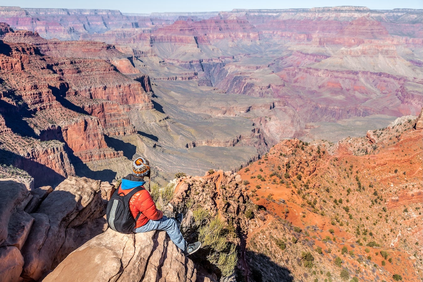
Grand Canyon (Detour from Williams or Flagstaff, AZ): While not on Route 66, the Grand Canyon is relatively close (about 60 miles north of Williams via AZ-64) and is a bucket-list destination for many. If you have an extra day or even a long afternoon, you can drive up to Grand Canyon Village on the South Rim. Williams offers the scenic railway or you can drive yourself – the South Entrance is roughly a 1.5-hour drive from Williams. Once there, take in the breathtaking overlooks (Mather Point, Yavapai, and Desert View are all fantastic). Sunset or sunrise over the canyon is unforgettable. Just plan accordingly, as it will add significant time (and an entry fee) to your trip. Many Route 66 travelers do make the side trip; after all, you’re so close! If you prefer to stick to the 66 corridor, another taste of canyon scenery can be found by driving the twisty road up Oak Creek Canyon from Flagstaff to Sedona (beautiful red rock country), though that’s south rather than north. Whichever detours you choose, be mindful of time and weather – storms can come quickly at high elevation. But if time allows, the Grand Canyon truly lives up to the hype and can nicely complement your Route 66 adventure by adding one of the world’s great natural wonders to your journey.
Cultural & Historical Attractions
Acoma Pueblo – Sky City (near Laguna, NM): This living pueblo is one of the oldest continuously inhabited communities in North America, believed to have been founded around 1150 A.D. It’s located atop a dramatic mesa about 15 miles south of Route 66 between Albuquerque and Grants. Visiting Acoma is a deeply enriching cultural experience. The Sky City Cultural Center offers guided tours that take you up to the mesa-top village, where you’ll walk among adobe buildings and historic churches (San Esteban Del Rey Mission dates to 1640). Acoma guides share the pueblo’s history and traditions. You’ll see pottery artisans selling handcrafted pieces (Acoma pottery is world-renowned for its thin walls and geometric designs). Note that photography is restricted and allowed only with a permit – follow all guidelines out of respect. Tours typically last ~1.5 hours and run daily except certain tribal observance days (check ahead; the pueblo sometimes closes to public for ceremonies). Visiting Acoma gives context to the land you’re traveling through – this area’s story didn’t start with Route 66 or even the railroads, but with indigenous peoples whose descendants still call it home. It’s humbling and memorable.
El Rancho Hotel (Gallup, NM): Step into this 1937-built hotel and you might feel like you’re on a movie set – which makes sense, as dozens of classic Western films’ stars stayed here while on location. The El Rancho’s lobby is a two-story rustic masterpiece of Southwestern decor: open beam log ceiling, a grand staircase, Navajo rugs, mounted animal heads, and walls covered in autographed photos of Hollywood legends (John Wayne, Katharine Hepburn, Ronald Reagan – the gang’s all here). Even if you’re not a guest, you can wander the lobby, have a meal in the 49er Lounge or the restaurant, and soak up the old-fashioned ambiance. It’s a fun slice of Americana and film history on Route 66. The hotel sits right on old 66 in Gallup, easy to access. A quick stop can turn into an hour if you get chatting with the friendly staff or other travelers. If walls could talk, the El Rancho’s would tell some tales!
La Posada Hotel & Winslow Railroad District (Winslow, AZ): Another historic gem, La Posada is a restored 1930 grand railroad hotel designed by famed architect Mary Colter. It’s often regarded as her masterpiece. Even if you’re not staying overnight, you can tour the elegant public areas, stroll the gardens, and visit the on-site art gallery featuring works by Tina Mion. The hotel’s restaurant, the Turquoise Room, is one of the best dining experiences along Route 66 – a mix of contemporary Southwestern cuisine served in a setting that evokes the golden age of train travel. Outside, the Winslow train station is still active with Amtrak, and freight trains rumble by regularly. The whole district around La Posada is rich with history (the hotel itself has a small museum on Harvey Houses and Colter’s work). Winslow cares about its Route 66 ties – beyond the famous corner, you’ll find little interpretive signs about town. La Posada is a highlight for history buffs, architecture fans, or anyone who appreciates a relaxing stop steeped in 1930s atmosphere.
Arizona Route 66 Museum (Kingman, AZ): Housed in the Powerhouse Visitor Center in Kingman, this museum is a comprehensive introduction to Route 66’s legacy in Arizona. Through dioramas, old photographs, and vintage vehicles, it tells the story of the people who traveled 66 – from the Dust Bowl migrants of the 1930s (with an immersive exhibit of a family in a Model A loaded with possessions) to the mid-century tourists in their shiny convertibles. You’ll learn about how towns along the way boomed or busted, and see memorabilia from when Route 66 was in its prime. There’s also a short film and a gift shop with one of the better book selections on Route 66. The same building holds Kingman’s visitor center (worth picking up info if you’re continuing west) and a separate Electric Vehicle Museum. Allow about an hour for the 66 Museum to really absorb it. It’s air-conditioned (a nice break in summer) and inexpensive. Many travelers find visiting this museum at segment’s end ties together much of what they’ve seen on the road, giving context and appreciation for the journey and those who came before. Plus, just outside, that big Santa Fe steam locomotive #3759 is a great photo op, symbolizing the transition from railroads to highways in American travel.
Travel Tips for This Segment
Navigation & Road Conditions: The primary driving route from Amarillo to Kingman follows Interstate 40, which parallels or overlays old Route 66 for most of the way. Exiting the interstate to explore business loops or signed “Historic Route 66” segments is generally easy and worth the effort for more scenery and nostalgia. In Texas and eastern New Mexico, some original 66 segments are concrete or asphalt two-lane roads that run alongside I-40; they are drivable in any vehicle, just watch for the occasional rough patch or low speed limit in small towns. West of Seligman, AZ, the historic road to Kingman (via Peach Springs) is a well-paved two-lane highway – no services for about 70 miles, but the road itself is in good condition and offers a leisurely alternative to I-40. Always pay attention to road signs: flash flooding can occasionally close sections of old 66 in New Mexico during monsoon storms (late summer). Overall, a regular car or RV can handle this entire segment – no special vehicle needed, as long as your brakes are good for a few mountain grades and you carry a spare tire (there are long stretches without services to bail you out of a flat).
Fuel & Services: In the Texas Panhandle and New Mexico portion, towns are spaced 30–60 miles apart and nearly every decent-sized town has fuel. Still, it’s wise to keep your tank above quarter-full. Top off in major towns and carry extra drinking water, especially as you head further west. Albuquerque, Grants, Gallup, Holbrook, and Flagstaff all have multiple gas stations, including truck stops with diesel. Between Flagstaff and Kingman, if you take I-40, you have Williams, Ash Fork, and Seligman with gas. If you take Route 66 from Seligman through Peach Springs, note that Peach Springs has one gas station (hours may be limited), and otherwise nothing until Kingman – roughly 85 miles of empty road. So definitely fill up in Seligman or before. Same goes for water and snacks: have some on board. A cooler with drinks is your friend, as many stretches, especially in New Mexico and Arizona, are remote high desert. Travelers report that west of Kingman (in the next segment) the gaps get even larger (50–70 miles between services), so consider Kingman your last big stop to stock up if continuing. One more note: don’t rely on credit card readers at isolated gas pumps – carry a little cash in case of network outages in rural stations.
Weather & Timing: This segment covers a lot of altitude change, so weather can vary widely. In summer, expect very hot days in lower elevations: Eastern New Mexico and western Arizona deserts often exceed 100°F (38°C) in the afternoons. Plan outdoor walks (Cadillac Ranch, Petrified Forest trails, etc.) for mornings or early evenings to avoid heat exhaustion. Carry sun protection (hat, sunscreen) and plenty of water for everyone in the car. New Mexico’s high plateau can surprise you with afternoon thunderstorms in July/August – brief downpours or lightning are common then, but they usually move on quickly. In spring (April–May) and fall (Sept–Oct), daytime temperatures are much more moderate (60s–80s°F), ideal for sightseeing, though spring brings strong winds in the Texas/New Mexico plains. If traveling in winter, be prepared for cold nights (it can drop below freezing in Flagstaff and higher areas) and occasional snow. Flagstaff (6,909 ft) regularly sees snowstorms from December through March, and I-40 can have temporary closures or require slow travel in snow/ice conditions. The road over the Continental Divide in NM and the Hualapai Mountains near Kingman can also get snow. It’s wise to check weather forecasts a few days ahead for all key points (Amarillo, ABQ, Flagstaff, Kingman) to know what to expect. Monsoon season (late July–August) might bring heavy rains in Arizona – if a section of old road looks flooded, do not attempt to drive through running water. Otherwise, the roads are rarely impacted by weather.
Altitude & Health: You’ll be spending considerable time above 5,000 feet elevation, especially from Albuquerque through Flagstaff. Most people have no issues, but if you’re coming from sea level you might notice a bit of shortness of breath or fatigue initially – listen to your body, stay hydrated, and avoid heavy alcohol intake the first day or two at altitude. The air is thinner and drier at elevation. Use moisturizer or lip balm if you experience dryness. Also, UV radiation is stronger – even on cool or cloudy days, you can get sunburned quicker at 7,000 feet than at sea level, so use sunscreen. If anyone in your party has known altitude sensitivity, Flagstaff (almost 7k ft) is the highest overnight; consider spending a night at a lower town (like Gallup ~6k or Kingman ~3k) as needed. That said, thousands of travelers cross these elevations daily without problems. Just take it easy on strenuous activities until you acclimate (for example, maybe save that big hike for day 3 or 4).
Respecting Local Culture: Several Native American reservations and communities are along this route. When passing through Navajo Nation or Hualapai Reservation lands (around Gallup, Peach Springs, etc.), remember that these are sovereign areas with their own laws and customs. Obey all posted speed limits (which often decrease in reservation towns) and avoid wandering off the main road onto unsigned dirt roads. If you stop in a tribal community to buy fuel or groceries, be courteous and refrain from photographing people or homes without permission. Acoma Pueblo’s Sky City tour is a great example of how to engage respectfully and learn – always follow the guide’s instructions regarding photos and stay with your group. By being a thoughtful guest, you help ensure that outsiders remain welcome in these communities.
Connectivity & Navigation: Cell phone service is generally solid along I-40 and in towns, but as noted, it can be spotty on more remote stretches. Cell coverage fades in parts of rural New Mexico and certainly in far-west Arizona. Don’t rely on streaming navigation alone. It’s a good idea to have an offline map (Google Maps allows downloading map areas, or use a GPS device) or a paper atlas as backup. The Dyrt app’s offline campground data can also be handy for finding sites when you have no signal. Having CB radio or a satellite communication device isn’t necessary for this segment, but if you have one, it doesn’t hurt. If you break down in a dead zone, usually another motorist will stop to help (common courtesy on lonely roads), but you should carry a basic car emergency kit: spare tire (and know how to change it), water, coolant, flashlight, etc. Fortunately, this part of Route 66 isn’t as desolate as the Mojave ahead, but you’re still wise to be self-sufficient.
Health & Safety: Route 66 is generally very safe to travel, but a few tips: Watch your speed, especially on old 66 alignments that pass through small towns – speed limits often drop to 25 mph in town and police do enforce them (speed traps are a classic part of Route 66 lore!). When exploring roadside ruins or old structures (like abandoned gas stations in ghost towns), be cautious of unstable floors, broken glass, or snakes. Carry hand sanitizer or wipes – some rest areas are rustic. Never leave valuables visible in your parked car; petty theft is rare but can happen in tourist spots. Wildlife-wise, you might encounter elk or deer crossings in the Flagstaff-Williams area, especially around dusk – stay alert, as colliding with a deer can ruin a trip. Cattle can also wander onto open-range highway segments in New Mexico and Arizona (look for “Open Range” signs meaning unfenced). If you drive at night, use high beams when safe and watch for glowing eyes on the shoulders. Lastly, stay hydrated and use that sunscreen. The combination of sun, wind, and altitude can sneak up on you and cause dehydration or sunburn faster than you’d expect. Keep water bottles handy for everyone in the car. Taking these precautions will help ensure your road trip remains all about good times and memorable sights, with minimal hiccups.
Plan for the Next Leg: Kingman is the gateway to a much more remote stretch of Route 66 across the Mojave Desert into California. Take the time here to prepare if you’ll continue west. Fuel up (it’s usually cheaper here than in California), stock extra water and snacks, and maybe have your vehicle’s fluids and tires checked. The next segment from Kingman to Santa Monica includes the famous Oatman Highway, long desert miles, and the final push to the Pacific. It’s one of the most challenging parts of 66 in terms of distance between services and heat. But don’t worry – with the experience you’ve gained from Amarillo to Kingman, you’re well-prepared to tackle it. When you’re ready, check out our full Route 66 road trip overview or the guide for the Kingman to Santa Monica segment to see what adventures await as you cruise into the sunset of California.
Additional Segments & Resources
This Amarillo-to-Kingman guide is one part of the larger Route 66 journey. Whether you started in Chicago or are joining mid-way, you might find these related segments and resources helpful for planning the rest of your trip:
- Route 66 Overview: For a comprehensive look at the entire 2,448-mile route, including overall tips and background, see our Route 66 road trip guide covering Chicago to Santa Monica. It links out to each segment and contains quick facts and preparation advice.
- Previous Segment – Oklahoma City to Amarillo: If you’re coming from the east, check out the guide for the segment before this, which highlights Oklahoma’s and Texas’s panhandle attractions (like Tulsa’s art deco and the Big Texan Steak Ranch in Amarillo).
- Next Segment – Kingman to Santa Monica: Ready to head west into the Mojave and on to California? The next segment guide details the drive from Kingman through Oatman, across the desert to Barstow, and beyond to the Santa Monica Pier. It includes crucial info on long stretches without gas (fuel planning west of Kingman is essential) and must-see stops like the ghost town of Oatman and the Amboy Crater.
- High-Authority Resources: For official information and extra insight, consider these links:
- NPS: Petrified Forest National Park – official site with maps, trail info, and hours for the park on Route 66.
- Acoma Pueblo Sky City – official site for tour hours and cultural center info if planning the Acoma visit.
Popular Articles:
Articles on The Dyrt Magazine may contain links to affiliate websites. The Dyrt receives an affiliate commission for any purchases made by using such links at no additional cost to you the consumer.