

Greenbrier River Trail Milepost 63.8 Primitive Campsite
All you need for a great time, nothing more and nothing less!
Greenbrier River Trail Milepost 63.8 Primitive Campsite, Located between Clover Lick and Clawson, WV (south of Sharp's Tunnel)
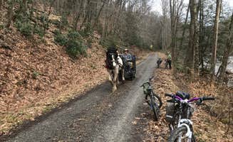
The Greenbrier River Trail is one of the most beautiful and often most remote trail I have had the privilege of bikepacking. If you aren't familiar with camping in West Virginia, you are in for a treat. The WV State Park system is fantastic and the State Park employees take incredible pride in keeping all their parks beautifully maintained despite poor budgets to work with.
GRT MP 63.8 Primitive Campsite is close to 17 miles south of the Cass Railroad Station. Trail conditions were wonderful, typical Railroad ballast, crushed gravel...at times it was wide like they recently removed the track, and other sections grass has grown down the middle to make it two track. All flat with a gentle one percent downhill grade from Stumptown to North Caldwell. Frankly, it wasn't discernible...but I'll take it.
Wildlife and songbirds were abundant and as shocked to see you as you were them. Oftentimes, the deer would run the trail ahead of you for 200 yards before cutting off onto their sidetrail.
The trail itself is recorded at differing lengths depending on what you read, but we started at MP 80…at Cass Railroad Station...traveling south to North Caldwell.
PROS:
- Free camping(First come, first served)
- Newer Adirondock Style Shelter
- Newer Large/Clean/Stocked Pit Latrine
- Raised Tent pad(pea gravel)
- Cold well water- Hand pump
- Metal Fire Ring
- No Cell Service
CONS:
- No Cell Service
NEARBY HIGHLIGHTS:
- Cass Railroad Station
- Snowshoe Mountain Ski Resort
- Seneca Forest (**Thorny Mountain Fire Tower)
- Seneca Rocks
- Spruce Knob(WV Highest Elevation)
- Green Bank Observatory
- The Greenbrier Resort
*Note in the video, I initially thought the steel containers were bear proof storage, but I was incorrect and they are bear proof trash receptacles.
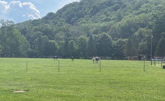
This is bear country, so we kept all our food items and toiletries in a bear cannister during our trip. We did not experience any encounters or sightings, but fellow cyclists traveling in the same direction, observed a juvenile bear during the day along the trail.
In fact, WV has an abundant wildlife population and it is evident along the Greenbrier River Trail, which set this trail apart from other bikepacking trails I've traveled.
You will see in a couple photos that a certain slithering resident was unwilling to give up his claim on this Adirondack Shelter, we attempted to dissuade him, we even gently relocated him, but he was neither afraid of our presence nor was he about to pass up a roof over his head. So we acquiesced and moved to the raised tent pad 100' down the trail. He was a very curious character.
In June, you can anticipate random, short afternoon or evening cloudbursts...but they can be gully-washers. Nights were cool and most mornings I wore a long-sleeve Merino shirt.
Riding and camping along the picture-perfect Greenbrier River offers fantastic views and opportunities to cool off...bring your swimwear.