This final stretch of the Route 66 road trip travels from the high desert of Kingman, Arizona to the Pacific shore at Santa Monica, California. It spans about 335 miles through classic Mojave Desert landscapes and historic roadside stops. Drivers cross into California’s vast desert, pass iconic spots like Oatman’s wild burro town and Amboy’s volcanic crater, and gradually re-enter civilization in the Los Angeles basin. Along the way are old Route 66 landmarks, open skies, and the challenge of sparse services. Plan for ~3 days to fully experience the quirky attractions and desert beauty. For a complete overview of the entire route, see our complete Route 66 road trip overview.
Crossing the Mojave Desert to the Pacific Coast
This segment is defined by the Mojave Desert’s remote expanse and the road’s historic terminus at Santa Monica Pier. Leaving Kingman, the route winds up to Oatman and descends to the Colorado River, entering California. The Mojave section features long, straight stretches of two-lane highway with rugged mountain backdrops and ghost towns. Travelers can expect extreme summer heat and 50–70 mile gaps between services. As the road nears the greater Los Angeles area, the desert gives way to suburbs and traffic. Spring and fall are the best times for this stretch – summer brings punishing temperatures, and occasional winter storms can affect mountain passes. With planning, drivers can safely enjoy the solitude of the desert and the excitement of reaching the Pacific.
Segment Quick Stats
| Total Distance | 335 miles (539 km) |
|---|---|
| Estimated Drive Time | ~6 hours (without stops) |
| State(s) | Arizona, California |
| Primary Route(s) | Historic Route 66, I-40, I-15, I-10 |
| Recommended Duration | 2–4 days |
| Cell Service | Spotty in Mojave Desert; good near towns |
| Fuel Stops | Kingman; Needles (last gas for ~100 mi); Barstow |
Day 1: Kingman, AZ to Needles, CA (via Oatman)
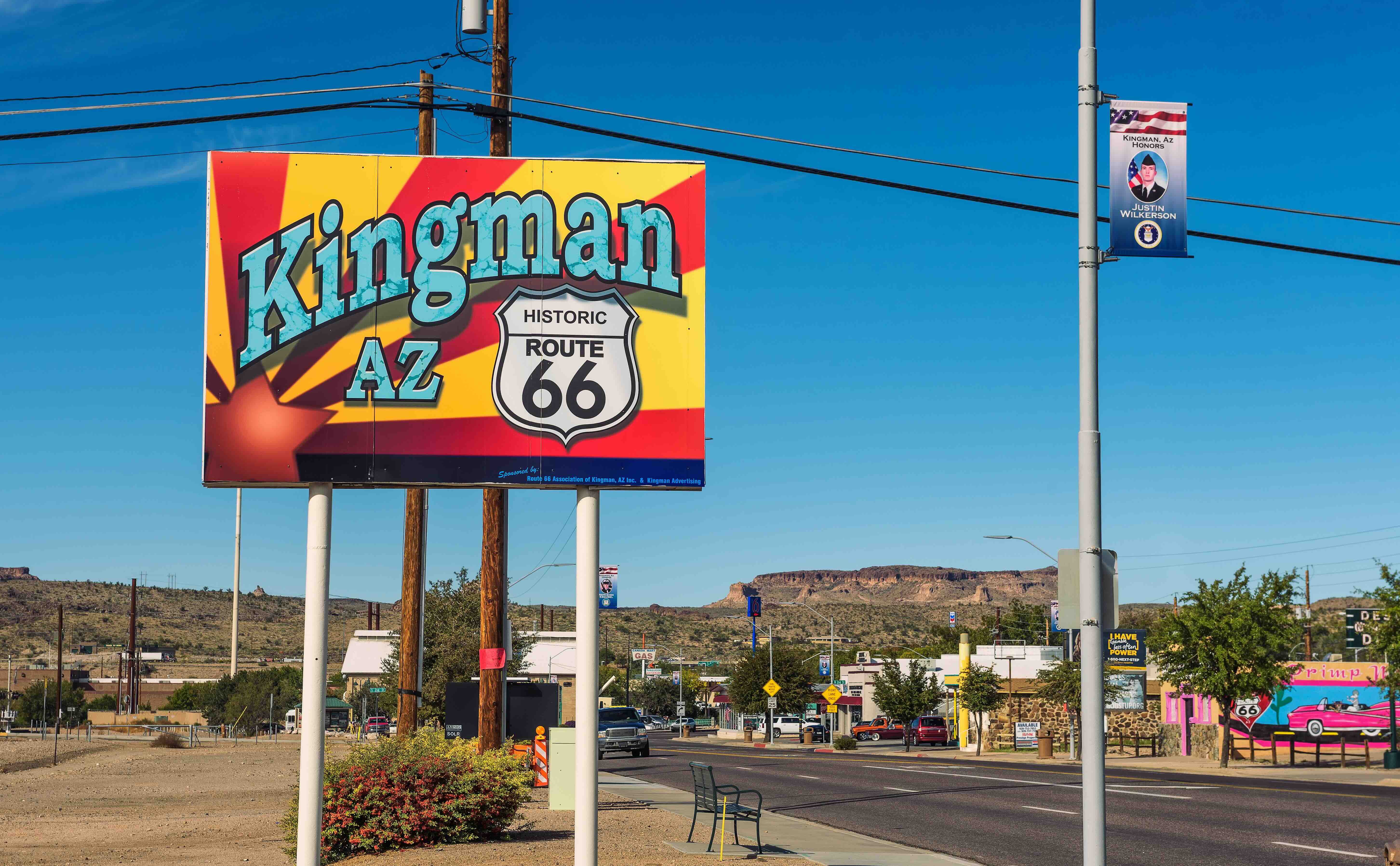
Distance: ~90 miles (including Oatman detour). Driving Time: 2–3 hours (plus stops). Start in Kingman, the self-proclaimed “Heart of Historic Route 66”. Before leaving town, consider visiting the Powerhouse Visitor Center, which houses Arizona’s Route 66 Museum and displays on the Mother Road’s history. From Kingman, follow Historic Route 66 (Oatman Highway) west into the Black Mountains. This winding stretch climbs over Sitgreaves Pass, then descends dramatically into the old mining town of Oatman. Watch for wild burros wandering the streets – these free-roaming donkeys are descendants of miners’ pack animals and now greet visitors in town. Oatman embraces its Wild West heritage with kitschy shops and staged gunfight shows on Main Street (weekends). It’s a fun mid-morning stop to stretch your legs, grab a cold drink, and snap photos with the burros (just drive slowly and yield to them on the road!).
Continue through the mountains to Golden Shores and Topock, where you’ll cross the Colorado River into California. The first town is Needles, CA, a historic railroad and Route 66 community. Fuel up here – this is the last reliable gas before Barstow, nearly 150 miles ahead. Needles has basic services, a few 1950s-era motels, and the Colorado River for those seeking a refreshing dip or some fishing. By afternoon, you’ll feel the desert heat intensify as you head west from Needles on National Trails Highway (Old Route 66). The road stretches for miles with sparse traffic and open vistas of creosote flats and volcanic mesas. Cell signal is intermittent, so have offline maps ready. Aim to reach a campsite by late day – Needles KOA on the edge of town is a convenient stop with tent sites, RV hookups, a pool, and even cabins for cooling off. Relax under the palms and eucalyptus, and enjoy a desert sunset as Day 1 winds down.
Day 2: Needles to Barstow, CA (Mojave Desert Highlights)
Distance: ~160 miles. Driving Time: 3–4 hours (plus stops). Day 2 tackles the most remote portion of Route 66 across the Mojave. Leave Needles early to beat the heat. The highway traverses empty desert basins dotted with joshua trees and volcanic cinder cones. Roughly 50 miles west of Needles, make a stop at Amboy, CA. Here sits the famed Roy’s Motel & Café, marked by its 1950s neon sign rising above the desert. Roy’s no longer offers lodging, but the gas station is operational and there’s a small store – a welcome pit stop. Don’t miss the giant “Route 66” shield painted on the road in front of Roy’s; it’s one of the few places where you can get that perfect Mother Road photo without traffic. A few miles beyond, consider a detour to Amboy Crater, an extinct black volcanic cone just south of the highway. Amboy Crater National Natural Landmark has a trailhead leading across a lava field and up the 250-foot cone (about a 3-mile round-trip). It’s a unique hike with panoramic views, but only attempt it in cool weather or early morning – summer temperatures routinely reach 110°F and have proven deadly for unprepared hikers. There is no shade or water on the trail, and prominent signs warn against midday hikes in warm months.
Back on Route 66, continue west through vast solitude. You’ll pass the tiny ghost town remnants of Chambless, Cadiz Summit, and Bagdad (nothing much remains of Bagdad itself). After about an hour of driving from Amboy (roughly 92 km/57 mi), you’ll arrive in Newberry Springs. Here stands the world-famous Bagdad Café, a quirky roadside café featured in the 1987 cult film “Bagdad Cafe.” The movie’s popularity (especially overseas) keeps this humble diner on the map. Inside you’ll find walls plastered with notes and business cards from global travelers. It’s a fun lunch stop – grab a slice of pie or a burger and soak in the Americana vibe. From Newberry Springs it’s about 20 more miles to Barstow. As you approach Barstow, Historic 66 joins I-40 for a few miles. Consider a quick detour north of town to Rainbow Basin Natural Area, a BLM site known for multi-colored rock formations. A short gravel road loop leads through rainbow-hued badlands; nearby, Owl Canyon Campground offers a primitive but scenic overnight option among the limestone cliffs. Arriving in Barstow by late afternoon, you’ll re-enter a city environment for the first time in days. Barstow has a proud Route 66 heritage – check out the Route 66 Mother Road Museum, located in the historic Casa del Desierto train station (open weekends). The town also features vintage motel signs and the classic El Rancho Motel from the highway’s mid-century heyday.
Overnight in Barstow area: If you prefer more amenities, Barstow has private RV parks and chain hotels. Campers can choose between Owl Canyon Campground (a quiet BLM site with picnic tables, fire rings, and vault toilets for just $6/night) or the Calico Ghost Town campground in Yermo, 10 miles east of Barstow. Calico’s campground sits below a restored 1880s mining town that’s now a county park attraction – a fun chance to explore Old West streets after hours. Either way, enjoy the intense desert stars here: the Mojave Trails area has virtually no light pollution and qualifies as a dark sky sanctuary, so on a moonless night you’ll have incredible views of the Milky Way.
Day 3: Barstow to Santa Monica, CA (Pacific Finale)
Distance: ~130 miles. Driving Time: 3 hours (plus city traffic). The last leg will bring you from the open desert into greater Los Angeles. In the morning, follow Historic 66 out of Barstow toward Victorville. Along old Route 66 (National Trails Hwy) in Oro Grande, make a brief stop at Elmer’s Bottle Tree Ranch. This folk art installation features over 200 “bottle trees” made from glass bottles welded onto metal poles, an eccentric desert road attraction. It’s free to wander among the clinking bottles (sunrise to sunset). Continuing south, you’ll arrive in Victorville, home to the California Route 66 Museum (open a few days a week; check ahead). From Victorville, Route 66 historically went over Cajon Pass. You can follow portions of the old road (Route 66/Caliente Rd.) toward San Bernardino, or simply take I-15 for convenience. As you descend into the Inland Empire, you may feel a bit of culture shock – traffic increases and modern development surrounds you. In San Bernardino, consider two quick pilgrimages: one to the original McDonald’s site (14th and E Street), which is now a free historic museum about the fast-food chain; and another to the retro Wigwam Motel on Route 66 in nearby Rialto. The Wigwam Motel, with its teepee-shaped concrete cabins, is one of only three left in the U.S. and remains an iconic roadside photo stop. (If you need lodging instead of camping tonight, you can even sleep in a wigwam – they still operate as a motel.)
The final push runs through the Los Angeles metro toward the ocean. Route 66’s historic alignment in the LA area changed over time; today you can generally follow Foothill Boulevard and Sunset Boulevard or take the I-10 freeway west. Expect urban traffic and plan your timing – mid-day or early afternoon can be easier than rush hour. Eventually, you’ll reach Santa Monica and the end of the road. Route 66 traditionally ended at the intersection of Lincoln and Olympic in downtown Santa Monica, but the symbolic finish line for modern travelers is the Santa Monica Pier. Drive to the pier area, then stroll out to find the famous “End of the Trail” sign on the wooden pier boardwalk. You’ve officially completed Route 66! Spend some time enjoying Pacific Park’s amusement rides, grabbing a treat, or simply relaxing on Santa Monica State Beach as the sun sets over the ocean. It’s a celebratory feeling to stand where the Mother Road meets the Pacific.
Overnight near the finish: Camping options are limited on LA’s congested west side, but Malibu Creek State Park is one great choice not far away. Located ~25 miles west in the Santa Monica Mountains, Malibu Creek State Park offers a peaceful campground amid oak and sycamore woodlands. It has well-maintained tent and RV sites with showers, and 15 miles of hiking trails through scenic canyons. (Fun fact: the park’s backcountry was a filming location for the TV series M*A*S*H.) From Santa Monica, it’s about a 40-minute drive to the campground. This lets you finish the trip with one more night under the stars—often much cooler and quieter than the city—and you can easily drive back into Santa Monica the next morning to continue your California adventure or head home.
 Best Campgrounds Between Kingman and Santa Monica
Hualapai Mountain Park – Kingman, AZ. Elevation 6,500 feet in the Hualapai Mountains just southeast of Kingman. This wooded county park offers a cool retreat in the pines before the desert crossing. Campsites (and cabin rentals) sit amid tall ponderosa pines and boulders, with frequent deer and elk sightings. Amenities include water, showers, and even a small camp store. It’s a perfect place to escape the heat – temperatures run ~20°F cooler than the low desert in summer.
Needles KOA – Needles, CA. A privately run campground on the eastern edge of the Mojave, convenient for Day 1. This oasis-like KOA features tent sites, pull-through RV sites, and rustic air-conditioned cabins. Tall tamarisk and eucalyptus trees provide rare shade. There’s a pool to beat the 100°F+ afternoon heat, plus a camp store, laundry, and Wi-Fi. It’s a comfortable stopover to recharge (and rehydrate) before venturing across the empty desert.
Hole-in-the-Wall Campground – Mojave National Preserve, CA. For a more rustic night under the stars, this first-come, first-served campground lies 20 miles north of Route 66 (exit at Essex Rd). It’s a BLM campground with 35 sites amid dramatic volcanic rock walls. The campsites are basic (picnic tables, fire rings, vault toilets; no hookups) but offer serene desert camping at 4,400 ft elevation. Hiking trails like the Rings Loop Trail explore the nearby slot canyons and unique “hole-pocked” rock formations. Expect brilliant night skies and quiet—no cell service here. Bring plenty of water (the camp’s spigot is seasonal) and be prepared for strong winds at night.
Owl Canyon Campground – Barstow, CA. A small BLM campground tucked in Rainbow Basin, 8 miles north of Barstow. Access is via a graded dirt road. The reward is striking high-desert scenery: colorful badland cliffs and limestone formations surround the 30 campsites. Sites have tables and fire pits; vault toilets are on-site (no water available). Campers love the solitude and stargazing: the Milky Way shines bright over Owl Canyon’s walls. Hiking the Owl Canyon Trail reveals fossil-bearing rock layers and hidden eroded caves. At only $6 a night, it’s an idyllic, off-the-grid stop — just be ready for a dusty drive in.
Calico Ghost Town Campground – Yermo, CA. This San Bernardino County campground lets you camp right below a famous ghost town. It offers a mix of full-hookup RV sites, dry campsites, and cabin rentals nestled in a narrow canyon beneath the restored Calico Ghost Town. Facilities include flush restrooms, showers, and a small store. By day, tour Calico’s 1880s mine shafts, pan for gold, or grab a sarsaparilla in the saloon. By night, campers get exclusive access as the tourist crowds depart – perfect for photography or ghost stories around the fire. There is little shade and it does get hot, but the historic atmosphere makes it a memorable stop.
Malibu Creek State Park – Calabasas, CA. A peaceful finale campground just 25 miles from Santa Monica. Malibu Creek’s campground sits in rolling foothills with oak groves and a burbling creek – a surprising natural haven so close to LA. There are 60+ sites suitable for tents or RVs (no hookups). Campers enjoy clean bathrooms with coin showers and real flush toilets. Hiking trails lead to the Rock Pool and century-old filming locations (the famous M*A*S*H set is a 2.5-mile hike from camp). Keep an eye out for deer and hawks in the evenings. Fires are restricted in summer, but cool ocean breezes and starry skies make for a relaxing end-of-trip camp. Reservations are recommended in peak season.

Top Activities & Attractions
Natural Highlights
Amboy Crater – Hike an ancient cinder cone in the heart of the Mojave. A 3 to 4-mile trail leads from a roadside parking area to the crater’s rim. The panoramic view at the top reveals black lava fields stretching 24 miles around the cone. Best attempted October–April due to heat – even in spring, start at sunrise to avoid triple-digit temperatures (hiking not advised in summer midday; people have suffered heat stroke and worse here). There’s a shaded overlook and pit toilets at the trailhead, but no water. Sturdy shoes are a must on the sharp lava rock. If you’re prepared, Amboy Crater offers an unforgettable otherworldly landscape right off Route 66.
Rainbow Basin & Owl Canyon – Just north of Barstow, this BLM natural area showcases multicolored sedimentary cliffs and fossil-rich badlands. A one-way loop road (high-clearance recommended) reveals green, pink, and beige striped hills – especially vibrant in late afternoon light. Hike the 1.5-mile Owl Canyon Trail to experience a winding wash with towering layered walls. It’s an easy-to-moderate walk, though you may scramble over some rocks. Wildlife watchers might spot jackrabbits or desert tortoises here. Sunset paints the basin in glowing hues, and after dark, the stargazing is phenomenal in these Bortle Class 2 skies.
Santa Monica Beach & Pacific Park – After days of desert, the Pacific Ocean is a welcome sight. Santa Monica’s broad sandy beach is ideal for relaxing or a celebratory swim (lifeguards are on duty in daylight hours). The beachfront path lets you bike or walk with ocean views. On the pier, Pacific Park offers a mini amusement park with a solar-powered Ferris wheel, roller coaster, and carnival games above the waves. It’s free to enter; ride tickets are available per ride or with an unlimited wristband. Even if you don’t ride anything, the pier at sunset is pure magic with street performers, the smell of funnel cakes, and panoramic views of the coastline. It’s a fitting natural finale – the sun sinking into the Pacific at the “end of the trail.”
Cultural & Historic Sites
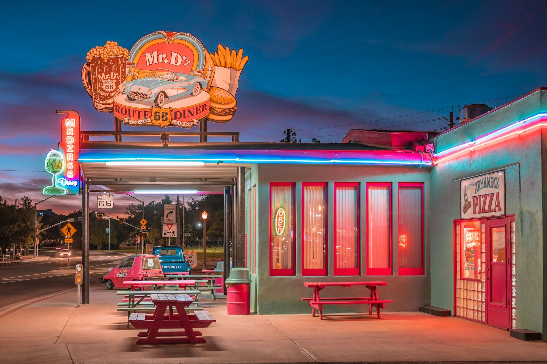
Powerhouse Route 66 Museum (Kingman) – Housed in Kingman’s historic Powerhouse building, this excellent small museum chronicles Route 66’s history in Arizona. Exhibits include vintage cars, neon signs, and Dust Bowl-era photographs. A highlight is the collection of Mr. D’z Route 66 Diner memorabilia and a 1950s Studebaker. It’s a great first stop to get context on the journey ahead. The adjacent visitor center has maps, brochures, and friendly advice.
Oatman Ghost Town – A living slice of Old West history on Route 66. Oatman’s wooden sidewalks and false-front buildings have hardly changed since the 1910s. Donkeys wander freely, and many are happy to accept carrot snacks (sold in town). Twice daily on busy weekends, volunteer “outlaws” stage gunfight skits on Main Street, complete with loud blanks – a fun family-friendly show. Don’t miss the Oatman Hotel, where Clark Gable and Carole Lombard honeymooned in 1939, and be sure to sign a dollar bill to tack onto the bar’s wallpaper. It’s touristy but charming, and gives a sense of the boomtown atmosphere that once filled these desert hills.
Route 66 “Mother Road” Museum (Barstow) – Located in Barstow’s restored 1911 Harvey House train depot, this free museum is packed with artifacts from Route 66’s California days. You’ll see old service station signs, classic gas pumps, maps of decommissioned road alignments, and even the “Cadillac Ranch” bumper art. Volunteers often have great stories about the road’s heyday. The site’s history as a Harvey House adds to the appeal – upstairs you can also visit a railroad museum and vintage rail cars. Open Friday-Sunday; allow 30–60 minutes for a quick tour.
First Original McDonald’s Museum (San Bernardino) – The site of the very first McDonald’s (opened 1948) is preserved as a kitschy museum on Route 66 in San Bernardino. Look for the red and white tile building and retro sign out front. Inside is an extensive collection of McDonald’s memorabilia from over the decades – old uniforms, Happy Meal toys, vintage menus – as well as exhibits about Route 66. It’s a quirky stop but delightfully nostalgic, and admission is free (donations welcome). Note: it’s closed Sundays.
Santa Monica Pier & 66 End of Trail Sign – The Western terminus of Route 66 is marked by the “End of the Trail” sign on Santa Monica’s century-old pier. This is a must-see photo op to commemorate your journey. The pier itself, built in 1909, is a piece of history – it’s had a carousel since the 1920s (still operating) and was a popular pleasure destination even before Route 66 was born. Today the pier bustles with souvenir shops, an arcade, and the historic Playland Carousel. Grab a bite at Pier Burger or a milkshake at Soda Jerks in the Merry-Go-Round building, and appreciate the fact that travelers have been celebrating here for generations. The nearby 3rd Street Promenade is an open-air pedestrian mall that’s great for people-watching and picking up any last souvenirs from your trip.

Outdoor Recreation
Hiking at Mojave National Preserve – If you have time for a side adventure, Mojave National Preserve (north of Route 66 between Needles and Barstow) offers excellent hiking. The Hole-in-the-Wall Rings Trail is a short but exciting 1.5-mile loop where you climb through narrow canyons using mounted rings for handholds. You can also trek the massive Kelso Dunes – 600-foot tall sand dunes that emit a “booming” sound when disturbed. Always carry ample water and avoid afternoon hikes; the preserve is rugged and largely undeveloped. But the silence and raw desert scenery make it worthwhile for avid hikers.
Colorado River Water Sports – In Needles or nearby Topock, the Colorado River invites a refreshing break from the road. Several outfitters rent kayaks and canoes for paddling the calm stretch of river through Topock Gorge, where you’ll see clear water, marsh reeds, and maybe wild burros onshore. Fishing for striped bass and catfish is another popular pastime – Arizona-side fishing licenses can be used on the river here. If nothing else, a quick swim at Needles’ Park Moabi (Pirate Cove) or at the community beach will cool you off. Just mind the current and boat traffic, and always wear a life jacket when boating.
Malibu Creek State Park Trails – Once you’ve reached the LA area, Malibu Creek State Park provides a natural playground in the Santa Monica Mountains. The park has over 8,000 acres of backcountry to explore. Favorite hikes include the 2-mile trail to the Rock Pool (a scenic swimming hole beneath volcanic cliffs) and the 5-mile round-trip to the M*A*S*H TV show filming site, where rusted military vehicles still remain as props. Mountain bikers will find several multi-use trails as well. Wildlife is abundant – keep an eye out for deer, red-tailed hawks, and even the occasional mountain lion (rarely seen, but present). It’s hard to believe you’re so close to the city. Note: summer days can be hot here too, but mornings and evenings are usually pleasant, and the campground’s oak trees provide decent shade.
Unique Roadside Stops
Roy’s Motel & Café (Amboy) – A quintessential Route 66 icon, Roy’s features a towering vintage neon sign and mid-century modern architecture that seems frozen in 1959. Though the motel is long closed, the café and gas station have been partially revived – you can buy snacks, cold drinks, and even fuel (at a premium price) during limited hours. The setting is wonderfully remote. Many travelers park here to photograph the sign and the giant “Route 66” shield on the highway. Roy’s has also starred in movies and music videos, adding to its mystique. It’s a required stop to capture the spirit of the Mother Road in the Mojave.
Bagdad Café – This unassuming diner in Newberry Springs became a global pilgrimage site thanks to the 1987 film Bagdad Cafe. Formerly the Sidewinder Café, it was renamed after the movie gained a cult following. Today you’ll often find tour buses of French visitors (the film was hugely popular in France) and walls covered in foreign currency and traveler mementos. The café itself is delightfully worn-in; grab a coffee or root beer float and chat with the owner about the movie lore. It’s one of those only-on-Route-66 oddities that’s easy to love. Even the sign out front has a leaning quirkiness. If you enjoy offbeat travel stops, you’ll dine out on the story of visiting Bagdad Café for years.
Elmer’s Bottle Tree Ranch – A forest of bottle “trees” in the middle of the desert, created by one man’s vision. Elmer Long began welding poles and balancing bottles on them in the late 1990s, and his installation grew to hundreds of bottle-adorned metal trees of varying heights. Old road signs, wagon wheels, and other salvaged oddities add to the charm. After Elmer’s passing in 2019, his family keeps the site open to visitors daily until dusk. There’s no fee, but donations are accepted. The sun filtering through colored glass makes for magical photos. It’s a peaceful, whimsical stop – just you, the tinkling sound of bottles in the breeze, and a testament to roadside creativity.
Wigwam Motel (Rialto/San Bernardino) – “Have you slept in a wigwam lately?” This classic motel advertises its 30-foot-tall teepee-shaped rooms with that famous slogan on a neon sign. Built in 1949, the Wigwam Motel in Rialto lets guests stay in one of 19 concrete teepees arranged in a village circle. Even if you don’t stay overnight, it’s worth pulling in to snap a photo and chat with the owners, who have preserved this bit of Americana. The neon sign lights up at night, and vintage cars often park out front for added atmosphere. It’s a prime example of the novelty architecture that once lined Route 66, and one of the last of its kind. A kitschy, happy detour.

Travel Tips for the Kingman–Santa Monica Segment
Fuel and Water: Gas up in Kingman or Needles and don’t pass a station with less than half a tank in the Mojave. The longest stretch without services is roughly 100 miles (Needles to Barstow). Some fuel may be available at Roy’s in Amboy, but hours are not guaranteed – better to assume it’s closed. Carry plenty of drinking water for you and your vehicle (at least 1–2 gallons). The desert can be deceptively remote; a simple breakdown could leave you stranded in intense heat far from help, so having water and a vehicle emergency kit is critical.
Heat and Weather: Summer in the Mojave Desert is no joke. Daytime highs commonly exceed 110°F, and the dry air will dehydrate you quickly. Plan outdoor activities for early morning or early evening. If traveling in July or August, consider a pre-dawn start to your driving days – not only is it cooler, but sunrise in the desert is spectacular. Thunderstorms (monsoons) can occur in late summer and may cause flash floods that temporarily close sections of old Route 66. In winter, snow can occasionally dust the higher elevations near Cajon Pass, and freeway closures aren’t unheard of during big storms. Always check weather forecasts and road conditions (Caltrans Quickmap) before setting out each day. It’s better to wait out a storm in town than to risk driving through hazardous conditions.
Road Conditions: Historic Route 66 pavement in this region ranges from a decent two-lane highway to rough, patched sections. After years of flood damage, many old bridges have been repaired, but watch for “Road Closed” signs and follow detour instructions if present. If you see water on the road, do not attempt to cross it – turn around. Some stretches are very lightly traveled, so you might go an hour without seeing another car. Drive at a reasonable speed (most of the National Trails Highway is posted 55 mph) and be alert for wildlife on the road – especially burros near Oatman (they often stand on the warm asphalt at dusk) and coyotes or jackrabbits darting across at night. Having The Dyrt PRO downloaded maps or an offline GPS is useful since cell service disappears for long spans, and navigation can be tricky where the old road intersects I-40 exits.
Safety and Etiquette: The Mojave is beautiful but unforgiving. Always inform someone of your route and schedule when crossing the desert. Check your spare tire and carry basic tools; a can of tire sealant isn’t a bad idea, given the distance to the next tow truck. Pack sunscreen, a wide-brim hat, and sunglasses – even a short walk on the salt flats or lava fields can roast you without protection. Practice Leave No Trace principles at desert sites: pack out all trash (there are few trash cans outside of towns), and leave rocks, bottles, and artifacts as you found them for the next traveler to enjoy. When visiting quirky stops like Bottle Tree Ranch or the Bagdad Café, patronize if you can (drop a donation, buy a soda) – it helps keep these mom-and-pop attractions alive. Above all, take it slow and savor this last leg. Plenty of people rush through to LA; instead, relish the quiet open road while it lasts.
Continuing Your Route 66 Journey
This segment from Kingman to Santa Monica is just one part of the legendary Route 66. If you’re doing the full trip, be sure to check out our other segment guides covering everything from Chicago’s Midwest charm to the high deserts of New Mexico. This journey’s end at Santa Monica Pier is really a beginning – the Pacific Ocean marks the finish of Route 66 and the start of new adventures. For more context on planning, see our full Route 66 road trip itinerary , which ties all segments together. And as you wrap up, remember The Dyrt’s resources: with The Dyrt PRO for offline camping maps, you can confidently explore even when cell service drops, and our community’s campground reviews ensure you find the best spots to stay. Thank you for traveling the Mother Road responsibly. We hope this guide helped you get your kicks on Route 66, and until the next road trip – happy trails!
The Dyrt is the only camping app with all of the public and private campgrounds, RV parks, and free camping locations in the United States. Download now for iOS and Android.Popular Articles:
Articles on The Dyrt Magazine may contain links to affiliate websites. The Dyrt receives an affiliate commission for any purchases made by using such links at no additional cost to you the consumer.