Imagine seeing the country from coast to coast, without spending a dime on gas or rushing by the landscape. A cross-country bike trip requires serious strength (or the commitment to pedal through the pain as your legs gain muscle, day after day.) But cross-country bike routes make the experience of powering yourself across the breadth of the United States possible. And those who tackle them will discover an astounding diversity in landscape, people, paths, and experiences.
These 6 Cross Country Bike Routes Bring Adventure on Two Wheels
Starting in the 70s, cross-country bike routes started gaining popularity as road bikes improved in quality and people wanted to find their way outside of the busy highway system. The TransAmerica Bike Route (see below) was established in 1973 and started a movement that attracts thousands of avid cyclists every year now. Most of these routes takes months to complete; the planning and logistics, even longer. These cross country bike routes are planned to put cyclists in places where there is camping and lodging available, and there are many great resources like the Adventure Cycling Association to help with making choices about daily miles and layovers.
Cyclists love the freedom of bike touring cross-country. Below are six varieties of cross country bike routes to choose from for your next great big adventure.
1. TransAmerica Bike Route
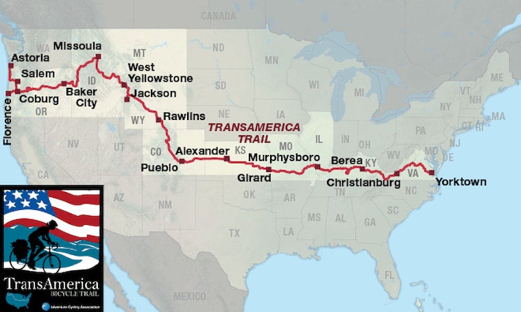
Image from the Adventure Cycling Association
The TransAmerica Bike Route is the classic bike touring route across America. At 4,626 miles, the route starts in Astoria, Oregon, and ends in Yorktown, Virginia. Start with days of riding next to the Pacific Ocean, then climb the Sierras. Ride through both Yellowstone and Grand Teton National Parks for some of the best views in the country, then find your way through the heartland to the Mississippi River. After winding through the lovely Appalachian Mountains on parts of the Blue Ridge Parkway, end in the historic Tidewater area of Virginia on the shores of the Atlantic.
Most people take more than three months to complete this route. It travels through temperate rainforest, arid high deserts, high alpine country, Midwest farmland and the old growth forests of Appalachia.
2. The Southern Tier
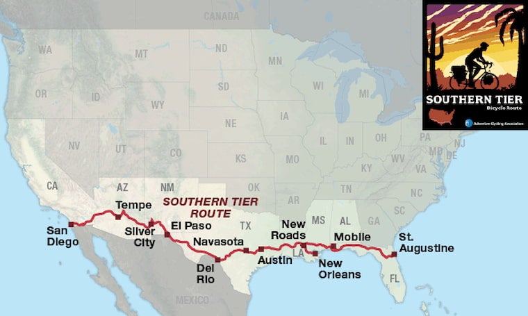
Image from the Adventure Cycling Association
The Southern Tier Bike Route is the shortest ocean-to-ocean connection, though it still tops out at nearly 3,050 miles. On the Atlantic side of it, the route begins in St. Augustine, Florida. Then, staying close to the Gulf Coast, it travels through Alabama, Mississippi and Louisiana with a popular out-and-back spur to New Orleans. Leaving the sea behind, cyclists travel through Texas with a stop in Austin, then across the rugged and dry West Texas plains. Touch the Mexican border in El Paso, then ride through stunning desert vistas of New Mexico and Arizona, finally ending at the Pacific ocean in California.
This trail is an incredible trip through southern and southwestern America, but the timing can be tricky. In summer, temperatures easily top 100 every day along many parts of this route. Winter often brings high winds and icy temperatures. Early spring and late fall are the preferred times for attempting the Southern Tier Bike Route.
The Easy Way to Find Last-Minute Campsites
Did you know some campers have:
- Pre-saved lists of hand-picked free camping across the US
- Text messages for last-minute openings
- Scans set up for National Park site openings
This is the easiest, most surefire way to find last-minute campsites every time, and it’s all included in the #1 camping membership called The Dyrt PRO. It costs just $35.99 per year and is an easy way to make sure you have better camping trips every time — and that you can actually find a spot last minute.
You can check it out for free today, you can even use it for free for 7 days to make sure you like it. After the trial it is $35.99 for a full year — most campers find it pays for itself after a night or two. If you camp more than 2 times per year, it may be perfect for you.
3. East Coast Greenway
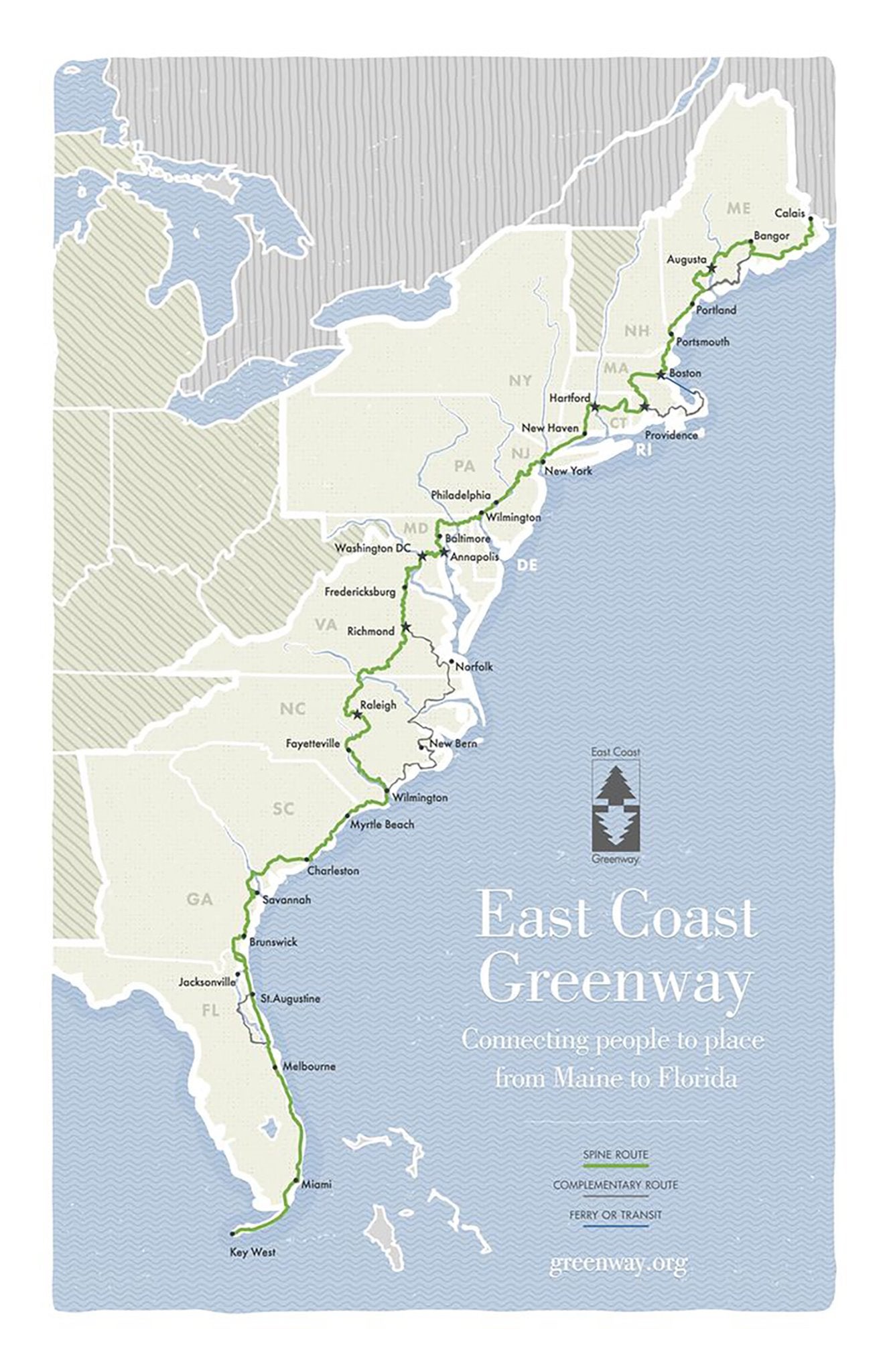
Image from The East Coast Greenway Alliance
The East Coast Greenway is the beautiful offspring of our country’s love affair with cross-country bike routes. The 3,000-mile route will eventually connect rails to trails multi-use pavement across 15 states up and down the Eastern Seaboard. Currently about 30 percent completed, it is still a lovely route with many quiet paved roads to choose from even where the trail system is in progress. Eventually, it will tie the Canadian border just north of Augusta, Maine, to Key West, Florida. With daily coastal views and countless historical and cultural landmarks, it is a beautiful route.
For those worried about challenging climbs, this is also a great route because it has only minimal elevation gain, traveling mostly along the coastal plains.
Ride from south to north to chase spring up the coast, or from north to south to watch the fall colors change for weeks on end.
4. Northern Tier
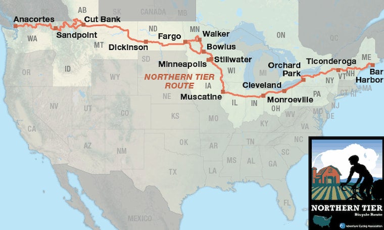
Image from the Adventure Cycling Association
The Northern Tier Bike route takes riders along the Great Lakes, through the backwoods of Wisconsin and Minnesota and up and over the Rockies in Idaho and Montana. This route is 4,244 miles long and connects Anacortes, Washington with Bar Harbor in Maine. Bring your passport to briefly cross the Canadian border in Alberta, and enjoy lakeside riding through Ohio and New York. There is some climbing on the western side of the route, with the highest pass being just over 5,500 feet in elevation, but it is an excellent route for exploring Big Sky country without climbing a pass every day.
The best season for this beautiful route is early summer. Prepare for bugs, gnats, and mosquitoes, watch out for ticks, and stay aware of changing weather in the plains of Iowa and Illinois. The route largely bypasses the major metropolis areas of Chicago and Des Moines, taking quieter roads through those regions.
5. Pacific Coast Bike Route
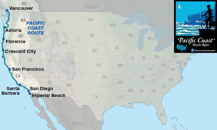
Image from the Adventure Cycling Association
The views of the Pacific Ocean along the Pacific Coast Bike Route never get old. At about 1,853 miles, the route is slightly shorter than some of the others, and many people try to link it up in just under two months. Heading from Vancouver, Canada to Imperial Beach, California, this route takes cyclists from temperate rainforests to the Redwood forests along the popular highways 101 and 1. Because of the heavy vehicle use of these roads, riders need to ride defensively and will not have quite as many restful backroads to cruise.
The traffic is the tradeoff for incredible coastlines, marine wildlife and the chance to ride through Olympic National Park. Because of its popularity, the best seasons for riding are off-seasons; fall is the best due to the likelihood of sustained dry weather while in the Pacific Northwest section of the route.
6. Great Divide Trail
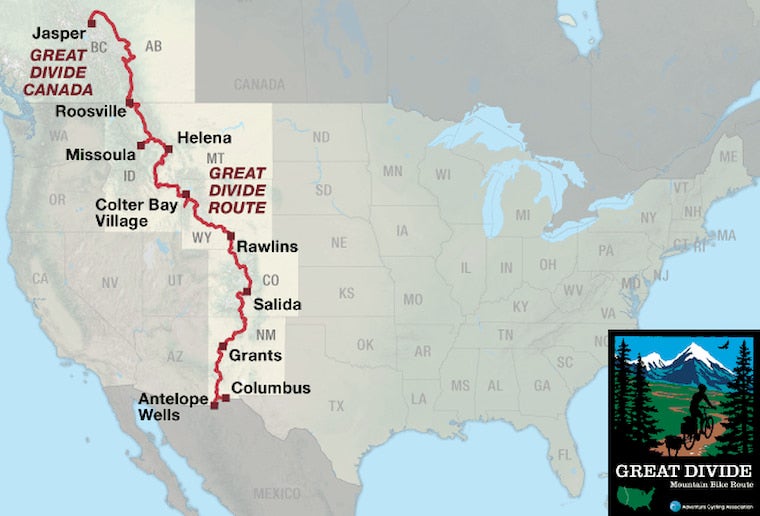
Image from the Adventure Cycling Association
For cyclists who are ready to push themselves to the max, with almost daily high-altitude climbs, the Great Divide Trail will give you all the right kind of suffering. The route has around 200,000 feet of elevation gain as it takes riders from Antelope Wells, New Mexico, to Jasper, Alberta in Canada. Although it technically doesn’t connect major bodies of water, it deserves a mention here, not only for the punishing altitude, but also because of the fact that it is the longest off-road bike route in the world at just over 3,000 miles. Traditional road bikes do not do so well on this route, as the packed dirt and gravel surfaces require a wider tire.
Criss-crossing the Continental Divide, the route puts riders at more than 10,000 feet in elevation on a regular basis. This altitude limits the window of use to just a few months in the summer when the mountain passes are free of snow. The word remote is an understatement in the National Forest and BLM lands of New Mexico, Colorado, Wyoming and Montana, so come prepared.
Related Campgrounds:
- Carlyle Lake Camping, IL
- Cisco Grove Campground and RV Park, Emigrant Gap, CA
- Starved Rock State Park, IL
Related Articles:
- C & O Canal Bikepath
Popular Articles:
Articles on The Dyrt Magazine may contain links to affiliate websites. The Dyrt receives an affiliate commission for any purchases made by using such links at no additional cost to you the consumer.

