


Established Camping
Pantoll Campground — Mount Tamalpais State Park
About
State Park
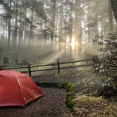
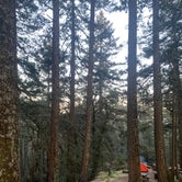
Located half way up Mount Tamalpais' forested southern slopes, Pantoll Campground is one of two first-come, first-served walk-in campgrounds within Mount Tamalpais State Park (Bootjack being the other). With 16 historic campsites lying beneath a quiet Douglas fir forest, time spent next to the campfire here will quickly expunge thoughts of the big city that lies just a few miles to the south.
The campground has an assortment of sites that are distributed on the hill that extends from the Pantoll Day Use Area; sites located further uphill offer greater privacy and more room. All 16 sites are within a short, 100-yard walk from the car park. Each comes equipped with campfire pits and historic, stone-built campfire grills to accommodate all of your cooking and warming needs. Since advance reservations cannot be made for Pantoll, arriver earlier on weekend days to ensure you’ll have a site. You’ll likely have the campground to yourself if you are there mid-week.
Access
- Walk-InPark in a lot, walk to your site.
- Hike-InBackcountry sites.
Stay Connected
- WiFiGood
- VerizonAvailable
- AT&TPoor
- T-MobileAvailable
Site Types
- Tent Sites
- Group
Features
For Campers
- ADA Access
- Trash
- Picnic Table
- Phone Service
- Drinking Water
- Toilets
- Alcohol
- Pets
- Fires

 Legend
Tent campground with plenty of hiking trails
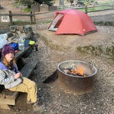
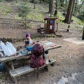
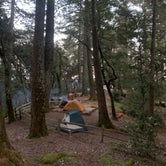
Pantoll is a pretty campground located adjacent to the entrance to Mount Tamalpais. You can hike to, bike to, take the bus to, or even drive to this campground. If you choose to drive, just know that it can be impossible to find a place to park on busy weekends (you'll need to drop your stuff off, find a place to park along the road, then come back to park in the evening when the parking lot clears). We hiked in. On a weekend night in March, only four of the 16 sites were taken so we had no problem nabbing a spot. The campground is situated across a steep-ish hillside. Water spigots are spread out among the sites, but all the bathrooms are located down the hill near the parking lot. Each site has a fire pit, picnic table, and a flat spot to pitch a tent. Sites are fairly close together in bunches (for example, 2, 3, and 5 were close, 6 and 7 were close, but there was a bit of space between the groups). Firewood is sold at the ranger kiosk but they have limited hours. Some spots are larger than others, and very few can accommodate a house-size tent (you know what I mean - and no judging, I have a house-size tent for car camping). We had our 3 person backpacking tent with us and it would have fit in all the sites. Sites up the hill require a bit of a hike-in but are farther from the road noise and busy parking lot. There is one dishwashing station near the bottom.
Pros:
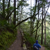
- Location. You can hike anywhere from this campground. Down to Muir Woods in less than 3 miles. Up to Rock Springs, Bolinas Ridge, and Mount Tam. Down to Stinson Beach. I could spend a week here exploring all the trails.
- Amenties. Dishwashing sink, many water spigots, food storage lockers, fire pits, toilets that flush. And Wifi from the ranger kiosk (squee!!!) which we appreciated to check the weather and bus schedule (very poor Verizon signal).
Cons:
- Noise from Panoramic Highway.
- Busy parking lot with lots of people potentially moving around the campground (especially the lower sites).
- No reservations: FCFS only.
Overall I'm really happy I finally got to chance to camp here and would recommend.
- (8) View All

 Guide
GuideFun day hikes
Area offers campgrounds but also its a good place to do day hikes. Its very close to San Francisco so it can get busy. Not the best place to be in solitude but it offers nice trails and views. Restrooms are available and there’s easy parking access.
 Guide
GuideBeautiful camp
14 walk in sites (all within a few minutes from the parking lot, which gets very busy during the day). We got the handicap site as it was empty after 5 pm. The other sites are beautiful and very secluded. Firewood available. $25, water at most sites. There is WiFi at the check in station.
Location
Pantoll Campground — Mount Tamalpais State Park is located in California
Directions
The park is located North of San Francisco's Golden Gate. From Highway 101 take Highway 1 to the Stinson Beach exit and follow signs up the mountain.
Address
1393 Panoramic Hwy
Mill Valley, CA 94941
Coordinates
37.903993 N
122.603886 W