
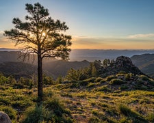
Sitgreaves National Forest manages Point Tank Near Larson Ridge as a dispersed camping area, giving drive-in campers direct access to national forest land outside the small community of Forest Lakes. No designated sites, hookups, or facilities are provided. Campers choose their own spot within the dispersed zone. Nearby dispersed options include FR 172 Dispersed — Sitgreaves NF to the southeast, useful for those scouting multiple pull-offs along the forest road network. Come prepared with water, a map, and a Leave No Trace plan.
RV Road Trip Guides

Map & DirectionsPoint Tank Near Larson Ridge is located in Arizona near Forest Lakes
 Dispersed Camping
Coordinates
34.38628491 N
110.8599645 W
Connectivity
 T-MobileNo Coverage
- VerizonNo CoverageVerified by 4 usersLast on 10/24/26
- AT&TNo Coverage
Connectivity
- T-MobileNo Coverage
- VerizonNo CoverageVerified by 4 usersLast on 10/24/26
- AT&TNo Coverage
Access
- Drive-InPark next to your site
Features
DISPERSED CAMPING
Enjoy dispersed camping on government land and leave no trace. Pack in and pack out. No (or limited) services at this camping area. Permit may be required.
PERMIT might be REQUIRED
We curate permit requirements across the US for our PRO members. Try PRO to see if Point Tank Near Larson Ridge needs a permit.
Drive Time
- 2 hrs 13 min from Phoenix, AZ
- 2 hrs 14 min from Prescott Valley, AZ
- 2 hrs 25 min from Flagstaff, AZ
- 3 hrs 30 min from Tucson, AZ

