SUMMARY PRESENTED BY
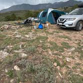
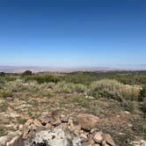
Tracking Station Road in Utah offers a dispersed camping experience surrounded by rocky terrain and sparse vegetation. Temperatures can range from highs of 90°F in summer to lows of 20°F in winter. Nearby, Arches National Park provides opportunities for hiking and exploring natural rock formations.
RV Road Trip Guides


Map & DirectionsTracking Station Road is located in Utah near Castle Valley
Coordinates
38.542886695266766 N
109.34212073866006 W
Connectivity
 T-MobileLTESome Coverage
- VerizonLTESome CoverageVerified by 2 usersLast on 7/27/26
 AT&T5GExcellent Coverage
Connectivity
- T-MobileLTESome Coverage
- VerizonLTESome CoverageVerified by 2 usersLast on 7/27/26
- AT&T5GExcellent Coverage
Access
- Drive-InPark next to your site
- Walk-InPark in a lot, walk to your site.
Site Types
- Tent Sites
- RV Sites
- Standard (Tent/RV)
- Dispersed
Features
For Campers
- Alcohol
- Fires
DISPERSED CAMPING
Enjoy dispersed camping on government land and leave no trace. Pack in and pack out. No (or limited) services at this camping area. Permit may be required.
Drive Time
- 2 hrs 25 min from Grand Junction, CO
- 3 hrs 50 min from Farmington, NM
- 4 hrs 11 min from Provo, UT
- 4 hrs 42 min from Salt Lake City, UT