

J
Jaap D. Traveler
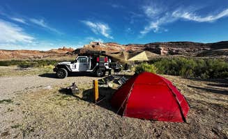
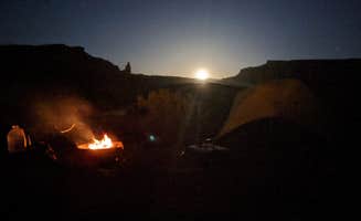
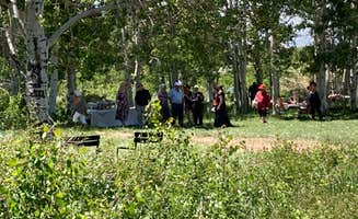
BLM North Klondike Bluffs Campground
Great place
Windy during the late evenining and night, but very beautiful!
244 campgrounds · Check availability for any dates.
Sparse services and raw canyon country define what camping near Cisco is actually like. This ghost town east of Green River sits on BLM land in the Book Cliffs corridor, with undesignated dispersed sites, no water, no restrooms, and no cell signal to speak of. It's a self-sufficient setup requiring you to pack in everything, including water for the full stay. Free camping outside Green River covers additional BLM access in the wider corridor if Cisco-adjacent sites are occupied or washed out.
Standard vehicles can reach most sites in dry conditions, but the clay roads here turn impassable after rain. The 14-day stay limit applies. Cisco sees minimal ranger presence, but BLM rules still apply. This is a good option for campers who want genuine canyon isolation without driving into more heavily used Moab-corridor BLM land.
"This campground is surrounded by tall majestic rocks high in the Utah desert. Well located to visit several National parks. Toilets and water scattered around this large site."
"Depending on how far you want to walk, there is access to several of the park's arches right from the campsite. Beware of Ravens!"
from $25 - $250 / night
Check Availability"Swam in the cold river, steps away from our tent. Great camp hosts."
"A little buggy but to be expected in July in Utah. Lots of space and great views."
from $150 / night
Check Availability"Small campground outside of Moab, Utah...the views, hiking, and access to the Colorado River are awesome."
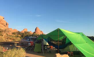
"This is one of our absolute favorite campgrounds in all of Utah! Not only are you surrounded by the tallest desert towers in the entire US! "
"Lots of room for over 100 rigs, tents, vans, though some are in close proximity to each other."
"My class b van handled the road well. 15 dollars paid through the Utah park ap."
from $30 - $50 / night
Check Availability"Willow Springs is awesome for the person that wants to be out in the middle of nowhere without really being super far away from something... it’s about 15 minutes outside of moab and directly off of the"
"this is the same campground as BLM dispersed camping outside of Moab, at blm378/willow springs trail roughly 12 miles north of Moab. plenty of space as there really are no designated spots, just be mindful"
from $30 / night
Check Availability"This is a great place to stay with access to the river. The only disappointing thing is that there are limited sites and they fill up quickly most weekends."
"Stopping here for the night, there are about 4 or 6 single campsite next to the group sites very spread out, level and a picnic table, quality new pit toilets is just fine"
from $100 / night
Check Availability"Low clearance vehicles can access sights closer to highway. Lots of camping spots tucked away if you continue down the road. Cattle around but bothersome. gorgeous red rock!"
"Lots of peeps camping here for the off-road experience and dirt bike/mountain biking trails."
"There are some campsites closer to the highway, but if you are intrepid you can travel a little further down and really nestle into some rocks in a small canyon."
"Great location, about an hour and a half from Moab, Utah which was our next destination. We were both impressed and will definitely camp here again."
from $20 / night
Check Availability"My wife found this spot while we were heading back to New Hampshire after 4 weeks in Utah. The trails getting in are fairly sandy but very easy to follow, I recommend 4WD and some clearence."
"Easy to get to, short ~20 off road to get to the camp site. Good signage along the way. Had a hard time finding in Apple Maps, but Google maps worked better."
from $28 / night
Check Availability"Pretty much just flat land surrounded by a primitive fence. No porta potty when I was there. It’s far enough away from the highway that cars aren’t bothersome."
"close to highway, quiet at night
- 15 minute drive to Moab/services
- less than 10 minutes to Arches/Canyonlands entrances/turnoffs
- no plant/tree cover for 🚽
- not many private sites but sites"

Windy during the late evenining and night, but very beautiful!
After a beautiful scenic drive on Rim Rock Road, pulled in and able to select and reserved campsite using QR code at site -$22. Think I was the only camper in loop C. Beautiful sunset and sunrise and interesting Night Sky program by Ranger at the amphitheater as the stars came out.
First time here, and would stay again. Got pretty windy when a rain storm passed through, but the cool breeze the rest of the night was worth my pop up canopy almost going over the edge!
It was great to stop here and jump in the pool. It was soo hot out! The grounds were clean and well kept. I appreciated the awning over the picnic table. The bathrooms and showers were great. It is in the middle of town, so expect to hear traffic through the night.
Had a quick one night stay on the way to Colorado. The park was clean and sites were spaced well. Walking distance to the green river. Kayak and SUP rentals available. There was ice available at park entrance if needed. I had 5g service with Verizon while there. My only complaint was the very loud group in the group site that had music going and Loud till after 11 pm .
Easy to get to, only 150yds off the main road. 4x4 strongly recommended, but not necessary in dry conditions. Campsite is flat and spacious with spectacular view of the valley. Temperature is 10 - 15 degrees cooler than in Moab, only 45 min away. There are a couple of other dispersed sights close by, but this site still feels very secluded.
The Campground is accessible via a paved road with large back-in sites suitable for a class A. Sites are gravel and level with a picnic table and fire ring. No hookups but nice location by the river with cliffs towering above. Pit toilets smelled like they needed to be emptied (you could smell them from about 50ft away) and lots of gnats in the evening. Very close to Arches NP. $20 per night - bring cash as the card machine was out of order). We pulled in around 3pm on a Saturday to try our luck and there were at least 2 sites available (we grabbed one). Would be a great spot if it wasn’t so hot in July. We didn’t want to disturb the other campers by running our generator in the evening and there was no breeze so no-one got much sleep.
We stayed for 1 night in our class A RV late July (after a sweltering night dry camping) to refill the tanks and cool off in the pool. It wasn’t too busy and we had the aircon running and were near the back of our row so weren’t disturbed by the road noise. The sites are well shaded, level and paved and the restrooms were clean. The pool was heated, clean and not too crowded. Great location with shops & restaurants within walking distance and only a short drive to Arches NP. Would stay again.
We camped here before it wasa state park. Back then it was free. This is agreat place to camp if you are riding SXS or biking. Plenty of easy access to trails. August is not a good time to visit. Very hot.
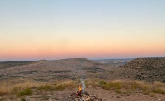
The Colorado River region near Cisco, Utah sits at approximately 4,300 feet elevation, characterized by arid conditions with summer temperatures often exceeding 100°F and winter lows dropping below freezing. The landscape transitions from red rock canyons to high desert plains, creating diverse camping environments that offer varying levels of accessibility. The camping season extends from March through November, with extremes of both temperature and isolation defining the experience.
Hiking at Fisher Towers: This 2.2 mile trail leads to impressive viewpoints with minimal elevation gain. As Alan B. notes about Fisher Towers Campground: "Not only are you surrounded by the tallest desert towers in the entire US! The 'Titan' stands at just over 700' tall and is surrounded by other towers shooting into the hundreds of feet as well!"
Mountain biking at Sovereign Lands: Located about 20 miles from Moab, these trails offer technical terrain for intermediate to advanced riders. A visitor to the Dispersed Camping Outside of Moab mentioned: "Plenty of access to mountain bike trails in the area as well. Fire bans were in place at the time through summer to Nov 1st."
River activities year-round: The Colorado River corridor provides kayaking, rafting, and swimming opportunities. At Onion Creek, one camper reported: "Kayaking the Colorado River is always fun, might have almost died but still fun. We went during a hot week and boy was it hot. Hard to find shade other than the rock walls."
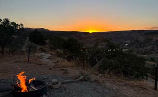
Night skies and astronomy: The area offers exceptional dark skies for stargazing, especially during new moon periods. A camper at Hittle Bottom observed: "We went in Mid April and it was quite windy, but the weather was beautiful. When you go on the no moon days you can see all the stars."
Smaller crowds at northern sites: Campgrounds further from Moab typically have fewer visitors. At Lower Onion Creek Campground, one visitor mentioned: "The campground is about .75mi off the road, so it is very quiet with no road noise from Hwy 128. The road was freshly graded that day so it was smooth despite the rain."
River access points: Many campsites feature direct access to the Colorado River. A visitor to Dewey Bridge Group Sites shared: "Literally on the Colorado River. Bring lots of water and tarps for hot sunny days. You can dip in the Colorado River. Just be safe."
Seasonal challenges: Summer brings intense heat while winter can bring snow and ice on access roads. A visitor to Knowles Overlook Campground warned: "Signage say high clearance 4x4 required, you could probably do it in dry weather slowly with 2 wheels."
Limited services: Most campgrounds have minimal amenities and no water sources. At Fisher Towers Campground, a camper noted: "There are picnic tables and metal fire rings, along with vault toilets, but there are no other amenities. So bring all your water and pack out everything."
Wildlife encounters: The area hosts numerous small animals including rodents, scorpions, and snakes. One camper at Hittle Bottom observed: "The critters are abundant, ants were awful, and apparently did bite according to our students that slept under the stars."
River safety protocols: The Colorado River current can be strong and unpredictable. A visitor to Lower Onion Creek Campground cautioned: "The river is nice to hang out in and maybe take a swim (if you're a strong swimmer) the current was strong."
Educational opportunities: Several areas offer dinosaur tracks and geological features for children to explore. At Willow Springs Trail, a camper mentioned: "The kids loved climbing the rocks and bonus there is a trail with dinosaur tracks! Even with the crazy wind we still had fun!"
Temperature planning: Consider bringing shade structures for daytime use. A visitor to Dewey Bridge Group Sites advised: "Bring lots of water and tarps for hot sunny days. You can dip in the Colorado River. Just be safe."
Road condition alerts: Many access roads require high clearance vehicles. At Willow Springs Trail, one RVer noted: "Open dispersed free camping along a gravel BLM road. Went all the way to the end and the road was fairly smooth in our dodge promaster."
Size limitations: Several campgrounds cannot accommodate larger rigs. At Fisher Towers Campground, a visitor warned: "The campground itself is nothing special amenity wise. It is a small CG that is first come first served for 5 sites that hold 10 people max and cost $15. These sites are tent only so no RVs."
Early arrival strategy: Sites fill quickly during peak seasons. A visitor to Hittle Bottom recommended: "We arrived on a wed around 5pm in Sep and there were still a couple of tent sites available while all other campgrounds were full. They have fire pits so make sure you bring wood to make a campfire."
Frequently Asked Questions
Where is Cisco campground located and how do I get there?
Cisco is located near Moab, Utah, with excellent access to the Colorado River and surrounding red rock country. Similar to Hal Canyon Campground, which is situated right off Route 128, Cisco provides convenient access to the area's natural attractions. To get there, you'll need to drive along Highway 128, which runs alongside the Colorado River. The campground is accessible by standard vehicles, though some of the more remote camping areas in the region, like those at Rabbit Valley — Mc Innis Canyons National Conservation Area, may require 4WD capabilities.
What amenities are available at Cisco campground?
Cisco campground offers basic amenities similar to other BLM sites in the area. For comparison, Goose Island Campground along Highway 128 costs $15/night and includes walk-in sites with water access. Most campgrounds in this region provide toilet facilities and access to the Colorado River. If you're looking for more amenities, Seven Mile RV Park offers a simplistic but beautiful alternative just a few miles from Moab with excellent stargazing opportunities and sunset views, though without resort-style facilities like pools or organized activities.
When is the best time of year to camp at Cisco?
Spring and fall are the best times to camp at Cisco, offering pleasant temperatures and stunning scenery. Sand Flats Recreation Area near Moab experiences similar ideal conditions during these seasons, with campsites featuring incredible views of red rock formations. Summer months can be extremely hot, while Fisher Towers Campground visitors note that despite the beautiful views, hiking, and river access, summer heat can be challenging. Winter camping is possible but comes with colder temperatures, though you'll enjoy fewer crowds. The desert climate means dramatic temperature swings between day and night regardless of season.
Keep Exploring