


Established Camping
Upper Burnt Corral

About
National Forest
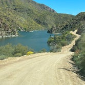
State Hwy. 88 is a narrow winding mountain road, with a maximum vehicle length limit of 40 feet. Not recommended for trailers over 22 feet.
Access
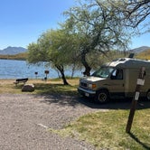
- Drive-InPark next to your site
- Boat-InSites accessible by watercraft.
Stay Connected
- WiFiUnknown
- VerizonUnknown
- AT&TUnknown
- T-MobileUnknown
Site Types
- Tent Sites
- RV Sites
- Group
Features
For Campers
- Trash
- Picnic Table
- Firewood Available
- Phone Service
- Reservable
- Showers
- Drinking Water
- Toilets
- Alcohol
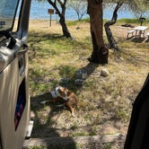
- Pets
- Fires

 Traveler
Love this campground
Worth the drive! Heard the drive is crazy but I didn’t think bad just slow going. Great spots reservable at lower campground with fcfs sites and open space camping at upper. So great.
 Traveler
Camp on a spectacular lake with mountain views
Beautiful drive to the camp grounds and plenty of spots. Small sites with not much privacy, but if you luck out there are some corner sites with privacy. Many sites are on the water and all of them have ramadas
Location
Upper Burnt Corral is located in Arizona
Directions
This site is 5 miles south of Roosevelt Dam on the south shoreline of Apache Lake. From Apache Junction: Drive north on State Hwy. 88 for 39 miles (the last 20 miles of State Hwy. 88 are unpaved) to Forest Road (FR) 52/Upper Burnt Corral Recreation Site. Turn left and continue to site. From Mesa: Take State Hwy.87/Beeline Highway north for approximately 60 miles to its junction with State Hwy. 188. Turn right onto State Hwy. 188 for 33 miles to its junction with State Hwy. 88. Turn right onto State Hwy. 88, and drive past historic Roosevelt Dam (unpaved) for 5 miles to Forest Road (FR) 52/ Upper Burnt Corral Recreation Site. Turn right and continue to the site. From the Globe area: Take State Hwy. 188 west for 30 miles to its junction with State Hwy. 188. Turn left onto State Hwy. 88, and continue past historic Roosevelt Dam (unpaved) for 5 miles to Forest Road (FR) 52/ Upper Burnt Corral Recreation Site. Turn right into the site.
Coordinates
33.63375529 N
111.2034654 W