
Fishing, hiking, and creek access draw campers to this US Forest Service site in Boise National Forest, where the terrain shifts between forested cover and open ground near the water. The campground runs April through October and has drinking water and toilets on-site. RVs are limited to 20 feet. The access road is rough, so drivers should account for that before arrival. Nearby, Willow Creek Campground sits about 2.4 miles southwest for campers weighing options in the corridor.
Description
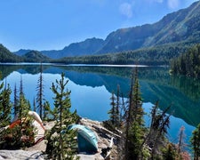
Overview: A stay at Badger Creek Campground enables guests to enjoy all the beauty and recreation offered around the Middle Fork Boise River (Forest Service road 268). Arrowrock Reservoir is just west of the campground and one of the **** premiere destinations for fishing, boating and waterskiing in southern Idaho. Weather is usually good from mid-May through late September and is easily accessible by car in good weather, although the road is sometimes rough and the drive can be seemingly long. Checking with the Idaho City Ranger District (208-392-6681) on road conditions before heading out is recommended. Natural Features: The campground has 5 campsites situated along the river. Wildlife watchers may want to look for deer and elk. Waterfowl, eagles and osprey are attracted to the river. Recreation: Corral Creek trail #129 and the William Pogue National Recreation trail #122 are just north of the campground. Check the Idaho City Ranger District Motor Vehicle Use Map (MVUM) for trails in the area that are open to hikers, equestrians, mountain bikers and off-road vehicles. Click here for an Idaho OHV safety message. The Middle Fork Boise River offers excellent rainbow & cutthroat trout fishing and good swimming holes. Big game hunting is a popular activity in season.
RV Road Trip Guides

Map & DirectionsBadger Creek Campground is located in Idaho near Idaho City
 Public Campground
Directions
From Boise, Idaho travel north on State Highway 21 to Forest Service (FS) Road 268 (also called Middle Fork Boise River Road) turn-off. Travel along FS Road 268 road along the scenic Arrowrock Reservoir approximately 25 miles. You will travel past the Arrowrock Dam and several other campgrounds. Use caution FS Road 268 is narrow and can be rough. The Campground will be a few miles beyond the Willow Creek Campground.
Coordinates
43.6621808 N
115.71170075 W
Connectivity
 T-MobileNo Coverage
- VerizonNo Coverage
- AT&TNo Coverage
Connectivity
- T-MobileNo Coverage
- VerizonNo Coverage
- AT&TNo Coverage
Access
Site Types
- Tent Sites
- RV Sites
Features
For Campers
- Drinking Water
- Toilets
Drive Time
- 2 hrs 35 min from Boise, ID
- 4 hrs 9 min from Twin Falls, ID
- 5 hrs 28 min from Pocatello, ID
- 6 hrs 1 min from Idaho Falls, ID

