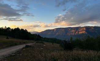
Bare bones but beautiful camping opportunity conveniently located near the trailhead to the Collegiate Peaks Wilderness Area in Colorado
Campground Review:
Needing a spot to serve as a staging area for a planned backpacking trip into the Collegiate Peak Wilderness Area of Colorado, my group discovered this gem. County roads (CR) that access national forests in Colorado often have primitive but established camping spots. Since we were going to start our backpacking trip from the North Cottonwood Trailhead, we searched online to make sure that the access road, CR 365 offered dispersed camping.
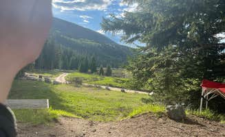
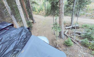
After a nice meal in nearby Buena Vista, Co, we headed out on the 7-8 mile drive to the trailhead. Now 7-8 miles on a CR isn’t always the same as a similar distance on a paved road. The first 3 miles on the drive from town center were paved and were navigated quickly and easily. The next few miles were not and driving became more of an adventure and slowed dramatically. While in the end we saw 2 WD vehicles at the trailhead, I would suggest that at a minimum you should have a high clearance FWD vehicle. Our Subaru Outback AWD served us well. The drive took us around 30 minutes.
2 miles away from the trailhead, you pass a Colorado Trail access point with parking and vault toilets. IMPORTANT: there are no toilets past this point on CR 365 and no facilities at the North Cottonwood Trailhead.
We ended up driving all the way up to the trailhead to know what to expect for the next morning when we would start the hike. We then headed back down CR 365 about a mile to some of the more attractive looking camping sites along the road. In all, I would suspect you pass 15-20 opportunities along the road. Some of them are small, single vehicle, single tent areas and others could handle multiple groups.
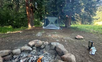
We ended up finding a pull off point that had a gravel road that accessed several campsites. You are encouraged to find sites that have been used in the past and most will have a fire pit. Always check with the ranger stations to see if fires are allowed in the area at the time.
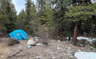
Since this site had a gravel road that took you 50-100 yards off the CR, you really felt the seclusion. The CR is not heavily traveled (maybe 6 cars used it from 7pm to 6am the next morning while we were there), being off the road really made this a nice site. The sites that are accessed via side gravel roads do have road designations. The one we chose was 365B and was clearly marked with a reflective post sign.
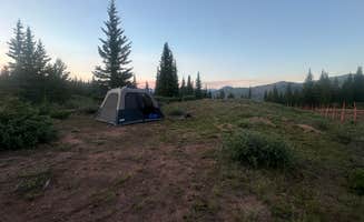
The sites are adorned with pines and aspens. We were also near a stream that provided us beautiful sounds to fall asleep to. Spacing between sites is significant so you do feel remote and won’t hear much if anything from other campers. Our site had a rock fire ring but firewood is scarce so if you want a campfire, you will need to bring some with you. There is no running water at these sites but the stream is flowing and with a filtration system, you can easily fill up. No tables or benches are in the area.
Does a bear … in the woods? Well yes and you will need to as well. This area’s minimum suggested practice was to dig your “cat hole” at least 6 inches deep, 100 feet or more away from water, camping and trail locations. Degradable toilet paper, no wipes, was suggested.
The site was beautiful, primitive, remote, and convenient. Everything we were looking for. We experienced temperatures of 70’s during the day and mid 40’s at night. We did have the typical misty rain in the evening but it didn’t last long and the ground absorbed it well. You are at around 9500 feet above sea level so you may feel the effects of the altitude. It served as a great place for this “flatlander” to get acclimated.
Not a site for someone that needs amenities. But if you love the thought of a controlled, primitive site, this will be right up your alley!
Gear Review: Wild Zora Foods
See a quick video summary of the product HERE.
As a Dyrt Ranger gear tester, I often get opportunities to evaluate camping related products during my outdoor adventures. On this outing, I was able to pack a variety of Wild Zora snacks and meals to help fuel this physically demanding trip.
The genesis for Wild Zora began in 2011 with a family that discovered the benefits of Gluten-Free, Paleo, and Primal foods. After developing their own, sharing with friends and family, the founders decided to package and offer their creations to the public. They offer meat and veggie bars, paleo meals to go, soups and teas. All are claimed to be prepared with minimally processed, high quality ingredients. The company states that it is mindful of diet restrictions and allergies.
Testing conditions:
I tested the product over several weeks under somewhat adverse but consistent conditions. The food was used to fuel a physically demanding trip where calorie dense foods were needed. I needed to be able to consume around 4000 calories a day to be able to backpack for miles and to climb 14,000 foot Colorado peaks. Space and weight were taken into consideration as well. We would be preparing the meals at high elevation which would affect how long and effective reconstitution of the dehydrated food would take. During most of the cooking times, temperatures were between 40-60 degrees.
Things that stood out:
· Conveniently packaged. Durable with no excessive packaging.
· Shelf life was way longer than what I needed for this trip so if any was left over, it would keep for my next trip.
· The meals and flavors offered are not limited to your common camping meals offered by others. CHECK OUT SOME OF THESE FLAVORS!
· There is no shortage of flavor in the meals. Nothing bland about them.
· Ingredients are top shelf and the meals and snacks have such a short but impressive ingredient list, you know you are doing your body good.
My preferences for improvement:
· Adjustment needed in how I ate it because of the dimensions of the meal packages. Narrow and tall vs short and wide made me adjust how I consumed the meal.
Summary of experience with Wild Zora:
These meals are POPPING with flavor! Since what we like in our meals is a personal preference, some may not like the strong flavors but I loved them. I am a little adventurous with my food and the flavors in all the meals I tried were distinct and pleasing – think gourmet vs fast food.
The food is packaged with the outdoor enthusiast in mind. Easy to tuck away in my backpack without being a space or weight hog and the snacks were perfect when I went “peakbagging” with a smaller daypack. Calorie dense. I was able to easily take 4 meat/veggie bars with my on mountain climbs and averaged 120 calories a bar. The bars provided satisfying protein and fat calories that complimented my quick carb foods I packed.
Will absolutely be a part of my meals on future adventures. See a quick summary of the product HERE.