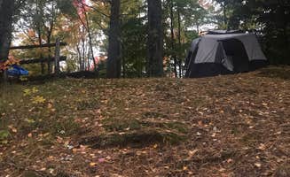
Tent campsites near Munising, Michigan primarily occupy national forest land, with elevations ranging from 600 to 900 feet above sea level throughout the Hiawatha National Forest region. The camping season typically runs from May through October, with July and August experiencing average daytime temperatures between 70-80°F. Winter temperatures regularly drop below freezing with Lake Superior creating significant lake effect snow accumulations, making off-season camping challenging without specialized equipment.
What to do
Snowshoeing expeditions in winter: The Pictured Rocks backcountry offers unique winter camping opportunities that most visitors never experience. "Traveling in the winter by snowshoes requires more planning and skill. We brought a sled and embraced the weather. Did see a few large bear prints on the way to the bear canister. Seeing picture rocks in the winter is well worth the adventure and exhaustion to get there," reports a visitor to Pictured Rocks National Lakeshore Backcountry Sites.
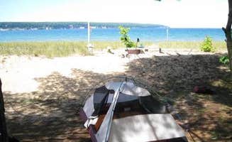
Lake swimming at designated beaches: Several Grand Island campsites provide beach access despite the chilly Lake Superior waters. A camper at Shelter Ridge Campsite On Grand Island notes, "It was nice to have a day to relax on the beach which is right in front of the site. Best part, it was nice enough for us to take a dip in Lake Superior!"
Well water access: Surprisingly, some remote sites offer potable water access, eliminating the need for filtration equipment. A camper at Hemlock Campsite mentions, "Potable well water is available along the hike in to the site, about .5 miles from the Hemlock campsite. We didn't expect this, and could have left our water filtration set up at home."
What campers like
Firewood provided: Unlike many wilderness camping areas, several Grand Island sites provide complimentary firewood. At Hemlock Campsite on Grand Island, campers appreciate that "Free firewood is provided right near the entrance to the campsite. We had no idea about this, and it was a great surprise."
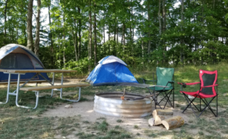
Small campground tranquility: The limited size of some campgrounds creates peaceful experiences even during busy seasons. At South Gemini Lake, a visitor observed: "This campsite was awesome! We camped right on the lake and due to how small the campsite is (only about 8 sites max). No reservations. You self-register when you arrive. The campsites were nice and flat, not too many trees but most provided an amazing view of the lake."
Beach access staircases: Some sites feature designated lake access points. At Hemlock Campsite, "Crystal clear lake superior is accessible by stairs near this campsite. Beautiful rocks to explore. When we went, the stairs were damaged and not open, though we were able to use them anyway."
What you should know
Bear safety infrastructure: Many tent camping areas provide specific bear protection amenities. At Channel Marker Campsite On Grand Island, "There is a primitive toilet at the site along with a bear pole and storage locker, and a campfire ring with grill top. The site is private yet still close to the trail with an adjacent trail down to the beach, both areas include beaches."
Severe insect activity: Biting insects can be extremely problematic during summer months. A Channel Marker Campsite visitor warns: "MOSQUITOES!!! They were horrible! We applied copious amounts of deet bug spray but these little buggers did not care. Swarms followed us and when they dispersed....well when there were less then 20 trying to suck you dry, the horse flies would start their attack flight patterns."
Tent placement restrictions: Some sites have specific regulations about where tents can be positioned. At Channel Marker, "The site requires that all tents are placed within 15 feet of a sign which only grants space for 1 tent easily. We also were able to fit one hammock within these guidelines."
Tips for camping with families
Beginner-friendly backpacking: Several sites offer accessible backcountry experiences for families new to wilderness camping. A visitor to Pictured Rocks reports, "We did 5 days and a 60 mile trek along the trail and the views were unbelievable. Fresh water you can filter along the trail but plan ahead. Designated camping so plan your hike out in advance. Well established sites with enough room to spread out if you book the group sites."
Kayak security: The strong winds at Lake Superior shoreline campsites require special precautions for watercraft. A camper at Shelter Ridge Campsite On Grand Island advises, "When camping here, bring your kayak inland off the beach. The strong winds here should not be trusted."
Flat access trails: Many Munising area tent campsites feature relatively easy approaches. At Hemlock Campsite, campers note that "The hike in is flat with some nice views of Lake Superior along the way."
Tips from RVers
Limited RV camping options: RV facilities near Munising are significantly restricted compared to tent options. At South Gemini Lake State Forest Campground, "We think tent camping would be ideal here, but we did see one small trailer. It is a small campground which meant it was very quiet mid-week. There were a couple boats that launched while we were there, but not a whole lot of other activity."
Drive distance to attractions: RV campers should plan for significant travel times to major attractions. A camper notes, "About a 45 minute drive to Munising. We took the cruise to check out pictured rocks and it was amazing."
Site proximity considerations: Some campgrounds place sites close together, limiting privacy. A reviewer warns, "The campsites are close to each other though so if you're looking for something where you don't have close neighbors I would recommend somewhere else."