Best Dispersed Camping near Jennings Randolph Lake

Dispersed camping near Jennings Randolph Lake can be found at several free locations throughout Monongahela National Forest. Canaan Loop Road offers numerous primitive sites with established fire rings. The road conditions vary seasonally, with some sections requiring 4WD vehicles during wet periods. A recent visitor mentioned, "There are a lot of spots visible from the road but there are also some hidden a few steps away from the road that are tricker to see while driving." Most sites feature fire rings marking suitable camping areas, with some located near streams.

Dolly Sods Backcountry provides more remote dispersed camping options for those willing to hike in. This wilderness area features diverse landscapes resembling northern climates. According to reviews, "There are so many incredible spots to camp pretty much everywhere along the trail." Be prepared for high winds, rain, and muddy conditions. The area requires proper navigation skills as trails lack markers. Additional dispersed camping can be found along Brushy Ridge Road and Squirrel Hollow Road, where primitive sites with stone fire rings accommodate tents and small vehicles. No facilities are available at these locations, so campers must pack in all supplies and pack out all waste.

Best Dispersed Sites Near Jennings Randolph Lake (14)

    1. Canaan Loop Road Dispersed

    13 Reviews
    Davis, WV
    30 miles
    Website
    +1 (304) 478-2000

    "This swath of land, sandwiched between two state parks(Canaan Valley State Park to the south& Blackwater Falls State Park to the north) is managed by the US Forest Service."

    "road is easy to drive on- some bumps but we were in a small kia sedan and it was fine, there are a lot of spots visible from the road but there are also some hidden a few steps away from the road that"

    2. Dolly Sods Backcountry

    11 Reviews
    Red Creek, WV
    30 miles
    Website
    +1 (304) 257-4488

    "Dolly Sods Wilderness Area, part of the Monongahela National Forest, offers something for every hiker, backpacker, camper."

    "Dolly Sods is a wilderness area within the great Monongahela National Forest. I backpacked here in early March a few years ago. Definitely be prepared for high winds and rain."

    3. Brushy Ridge Road Dispersed

    1 Review
    Cabins, WV
    26 miles
    Website

    "Brushy Ridge Road is Forest Service Road 75 and is in decent condition."

    4. Lower Glady Dispersed Campground

    10 Reviews
    Harman, WV
    40 miles
    Website
    +1 (304) 636-1800

    "So this is quite large, I'm guessing at least 25 to 35 campsites along a 4-ish mile long dirt road that deadends. It is dispersed camping, free."

    "Had direct access to water for washing and other needs. However I read in a brochure to not drink the water without boiling for 3 minutes because the area has giardia."

    5. Squirrel Hollow Road Camping

    2 Reviews
    Wardensville, WV
    35 miles

    "Sites are located less than a mile from the paved highway. We found 5 spots just off the road. All were easily accessible by cat or with a small teardrop trailer."

    6. Gladwin Dispersed Camping

    3 Reviews
    Red Creek, WV
    36 miles

    "Decided to try it even though other review said private property- and seems they were correct but incorrect. Initially you do come to private land with several campsites and campers present."

    "I camped at the site closest to the river— right next to it in fact!  And it was quite large."

    7. Squirrel Gap Rd Dispersed

    1 Review
    Baker, WV
    36 miles

    "But this one is right off the road, entrance is steep. Decent sized area, stone fire ring, plenty of firewood."

    8. Wolf Gap Recreation Area

    3 Reviews
    Basye, VA
    41 miles

    "Very nice spot, good tent setup pads and fire rings at all the sites, my one complaint is that it is right next to the road that while not frequently used, the occasional car can often take away from the"

    "The road leading to the camp site from Wardensville was in excellent condition all the way to the camp site. There are e total of 9 campsites."

    9. Edwards Run Wildlife Management Area

    2 Reviews
    High View, WV
    37 miles
    Website
    +1 (304) 558-2771

    10. Cedar Creek Trail dispersed campsite

    1 Review
    Woodstock, VA
    43 miles

    "Location is approximate. After the intersection, the road will turn into a trail (marked by a metal gate) and there is a campsite right there. Was very peaceful and clean."

Show More
Showing results 1-10 of 14 campgrounds

2026 Explorer Giveaway

Review Campgrounds. Win Prizes.

Enter to Win


Dispersed Camping Reviews near Jennings Randolph Lake

45 Reviews of 14 Jennings Randolph Lake Campgrounds


  • RThe Dyrt PRO User
    Dec. 27, 2025

    Canaan Loop Road Dispersed

    A remote loop route with about 10 dispersed, free campsites

    This swath of land, sandwiched between two state parks(Canaan Valley State Park to the south& Blackwater Falls State Park to the north) is managed by the US Forest Service. The nearest town is Davis, WV. 

    There is just one dirt road running through it, the first few miles of which are fairly tame: navigable by most standard cars and medium or smaller sized RVs. The further back in you go, the rougher the road gets until it is truly just a jeeps-only type of road. But the good news is that all of the camping sites take place before you get to that rough part. 

    And this is TRULY dispersed camping, with most of the camp spots being a good half-mile from each other! The one downside, if you are into privacy, is that all of the sites are RIGHT NEXT to that dirt road, so others will be driving past your site. The good news is that it is not a heavily trafficked road, used primarily just by the other campers in the 10 available spots, by the occasional hunter, and by the even-less-frequent off-roader, hoping to challenge their vehicle on the rough stuff several miles in. 

    This is all free camping, and all primitive. There are no restroom facilities, no showers, no electrical, no water supply. 

    The campsites themselves are mostly surrounded by forest, making even the smallest of them quite beautiful. They vary in size from being little more than a 20 foot driveway to back an RV up to those sites that are significantly larger with room enough for more than one vehicle and perhaps a couple or three tents. 

    While this loop road region has very few activities itself, you are just a few miles from the two state parks and from private facilities offering horseback riding, skiing, snowboarding, swimming, and more. 

    The loop road region itself has MANY trails for hiking or mountain biking (possibly horseback riding— I saw no signage either for or against it), and one trail that is specifically marked as a cross country ski route. Although, from what I can see, several of the trails could work for cross-country skiing, as even the road itself could right after a storm. 

    While the area is at a fairly high altitude, around 3000 feet, it seems to be built on a kind of high altitude plateau, so the road itself is not that hilly, nor are the camping sites. I don't know for sure if it's a year-round site, but I can tell you that I was camping there in December, no problem. I do understand that the road is minimally maintained, so it might be impossible or difficult to access during very snowy weather.

  • Dave V.
    Oct. 31, 2019

    Dolly Sods Backcountry

    Shoulder season solitude...flora and fauna delight

    Dolly Sods Wilderness Area, part of the Monongahela National Forest, offers something for every hiker, backpacker, camper.

    Having visited Dolly Sods numerous times at the Red Creek Campground, using that as the base camp to launch off to explore the myriad of trails. We decided to use the backcountry as a primer for the following year's longer westerly  backbacking trip. 

    Know that it will likely rain on you in Dolly Sods, so always bring rain gear. Also realize, that with climate and conditions similar to the Canadian Tundra, temperatures and winds vary and fluctuate often, any time of year. Those two conditions often dissuade less hearty souls...but they are also exactly what creates and sustains a very beautiful environment.

    During our excursion, we spent three nights and four days on what I will term the perimeter trails...camping at Raven Ridge, Big Stonecoal Run creek, and at Reds Creek at the forks. Numerous websites offer insight and directions and all are beneficial to study. We chose to travel counter-clockwise from Bear Rocks, parking in the grass across from the trailhead. Note: leaving valuables in or on your vehicle while you traipse about in the Sods is always iffy, just like anywhere else, so use wisdom. I've read of thefts...but the vehicle parked to us had two high end full-suspension mountain bikes on a roof rack for days without issue.

    If you are unfamiliar with Dolly Sods Wilderness trails...choose footwear that either dries fast or is waterproof...has a robust sole to fend off bruises from the brutal amount of sharp, ankle buster rocks on the trail...and won't pull off and be lost in the countless bogs and areas of shoe sucking mud. We wanted to rename one particular trail "pointed rock trail." Our expensive boots were actually a fail for this trip...which was a valuable education.

    We saw people run this trail in a day...but there's no way you can enjoy the sights, sounds, and smells moving that quickly. I felt we should've taken more time and explored much more...although soggy weather became a deterrent. The amount of brightly colored fungi, snakes, crayfish and salamanders were astonishing. So if you move too quickly, you miss them.

    Do practice "leave no trace." The heavy summer and weekend use by careless and selfish hikers or backcountry partiers...has left the woods adjacent to Reds Creek camping sites littered with toilet paper...dig your cat hole and bury your "goods!"

    The rocks on the trail may be a pain, but the formations and views from Raven's Ridge, Lion's Head and Bear Rocks rival the best.

    Do your homework, choose your camping gear and wardrobe wisely and launch off into the Dolly Sods Wilderness Area...you'll be glad you did!

  • Lucille W.The Dyrt PRO User
    Apr. 13, 2020

    Dolly Sods Backcountry

    Allegheny mountain wilderness

    Dolly Sods is a wilderness area within the great Monongahela National Forest. I backpacked here in early March a few years ago. Definitely be prepared for high winds and rain. We hiked in in warm weather and once we reached the top of a long entrance road (where one trailhead was) we found snow. A lot of the snow had melted making the ground very soggy and oversaturated in some areas. Despite this, our short Dolly Sods backpacking trip was an amazing first trek for myself and a fiend. Dolly Sods is absolutely gorgeous and is a completely different and unique ecosystem than the surrounding area. I also have friends who have camped here later in the year - mid to late summer - and have highly, highly, recommended that I go back during that time.

  • RThe Dyrt PRO User
    Dec. 5, 2025

    Lower Glady Dispersed Campground

    An odd mix of campsite types, but something for just about everybody!

    So this is quite large, I'm guessing at least 25 to 35 campsites along a 4-ish mile long dirt road that deadends. It is dispersed camping, free. And I guess it just depends on what you were looking for. I like to have something a little bit remote, where my campsite is not visible from other campsites. There isn't a lot of that here, but I did find maybe three or four that fit that description, all visible from the dirt road that goes through it. 

    There were many sites that I simply would not like it all, but might be ideal for your purposes, such as two or three areas where there is essentially a big field with a short loop road with maybe half a dozen campsites right next to each other. These are bordered by trees but there are no trees on those sites. Definitely not my cup of tea, but might be ideal for those who are in campers or motorhomes and what to be near a group of other people doing the same thing. 

    The pit toilets are good, reasonably clean. They are however even more dispersed than the campsites— roughly one every mile. Keep that in mind while you are picking a campsite. You may want to be close to one, and then that would limit your choices. If you don't care how close you are to one of the toilets, then you have lots and lots of choices. 

    One of the best things about this location is if you are into mountain biking or hiking or trail running. There are an absolute ton of choices for you, some of them starting right there from the campsite or right at the end of it and several more within half a mile. The Allegheny trail runs right through the campsite with the road itself serving as part of the trail, then immediately turning into singletrack trail on the far ends of this several-miles-long dispersed camping area.

  • Sean M.
    Aug. 2, 2020

    Dolly Sods Backcountry

    Wilderness of the West in the East

    The sods are a truly wild and remote place in an increasingly crowded East coast. For years Dolly Sods has been my go-to backcountry destination, even for chilly winter stays. Many places carry the “wilderness” moniker in the East, but this place lives up to it. No cell service, no car camping, no trail markers, no toilets, and no running water. It’s the real deal. During the off season you can hike for days and not see another person. There are some opportunities to camp closer to the trailhead for those only looking to dip a toe into wilderness travel, but you could hike for miles to a remote site as well. Be advised, a good physical map and compass, the skills needed to use them, are vital here. There are no trail marks and the path can be confusing. Come prepared and have a great adventure.

  • Kelly G.The Dyrt PRO User
    Aug. 29, 2021

    Brushy Ridge Road Dispersed

    Great location near Dolly Sods Wilderness

    Brushy Ridge Road is Forest Service Road 75 and is in decent condition. There are several pull off campsites along this road on the way up to Dolly Sods wilderness but this primitive group of three large unmarked campsites with stone fire rings is before you get to the Bear Flats Plateau and the Red Creek camp grounds. It is a 2.5 mile, 2000’ climb to get to the trailhead for Bear Rocks Trail in Bear Rocks Preserve which is about a half mile past the entrance to this unmarked group site. I camped in the middle of these three large campsites that are each about 100 feet away from each other. Firewood was available on a self serve honor system (put $5 cash in the box for each bundle you take) at the farmhouse across from the turn on to Brushy Creek.

  • Cherith S.The Dyrt PRO User
    Jun. 6, 2026

    Lower Glady Dispersed Campground

    Greatest experience of our lives!

    Super remote camp spot! The drive to the forest road was a little tight and windy for an inexperienced mountain driver as myself. Wouldn't want to do it at night.

    Most camp spots are on loops of more group camping with 4-6 sites at each loop and I believe there were 3 or 4 loops. Not my cup of tea, too fish bowl for me and way too exposed. Outside of the loops, there were 8-10 sites that were more my style, with the one we stayed at was just right! The most perfect spot in the whole place (for our preferences) we were literally on a babbling creek. Couldn't get any closer. Had direct access to water for washing and other needs. However I read in a brochure to not drink the water without boiling for 3 minutes because the area has giardia.

    Saw a lot of people headed further down creek to fish for trout. No cell service for about 20 minutes. We had to drive back to route 33 and the halfway to Elkins to catch a sliver of cell service.

    If you are staying at camp and brought everything you need, you're golden. There are lots of things to occupy yourself with exploring. There is a trailhead on forest rd 162 with miles of hiking with a hand full of trails to choose.

    We arrived around 4PM on a Sunday. Plenty of sites to choose from. Was about half full. When we got up the next morning to leave, most spots were open. We stayed until mid day on Friday. Action was definitely picking up. Saw more people, more kids and louder noises. We are definitely Sunday to Thursday campers. I want to camp without knowing the neighbors are there. When leaving on Friday most sites were taken.

    Had no problems finding plenty of fallen kindling for our fire. We found a great roadside house on route 33 that was selling firewood in their front yard for only $10 a "row" as they called it. We got 2 rows because we werent sure what to expect when we got there. We built a good hearty fire every morning and every evening and still had firewood we left there since there was so much accessible resources.

    We ended up doing a lot of "tourist" experiences that was a bit of a drive to get to due to my inexperience in driving in the mountains. The drives were usually 30 minutes to an hour and a half. But well worth the drive.

    Elkins is the closest place to "civilization" (north on 33) we went there for cheap gas, ice, and the grocery store. Didn't explore Elkins as it was too "city" for us. We wanted more remote experiences.

    Harman was the next closest place (south on 33) not much for exploring, but they have a dollar general (what remote town doesn't have a dollar general?) and a place for gas

    Continue on 33 south and hit Seneca Rocks! Such a beautiful sight to see! Also have the oldest general store built in 1902 and Yokums country store. Its like going back in time. Both tourist traps but worth the experience. We went to the recreation area with river access so beautiful to see the cliffs upclose and personal. If you are a climber this is the place for you. We are hikers. But enjoyed the views.

    Continuing on 33 south there is smoke hole caverns. Another tourist trap but fun. For $20 you get a cavern tour tack on a little more if you want to go gem "panning" and get a bag of dirt to find gems. Or putt putt. Giant gift shop. Someone said it was the largest gift shop in West Virginia.

    From Seneca Rocks if you head west on 28 it will take you past Seneca Caverns. They were closed for the summer due to blasting nearby.

    Continuing on 28 west you then come to one of my favorite spots. Spruce Knob. The highest elevation in all of West Virginia, gorgeous views all around! Terrible observation tower that you cant see anything due to trees. Nice picnic area. Going down the other side of the mountain Spruce Knob lake, lots more trail heads AND a fantastic dispersed camping area! Seneca Creek backcountry. Didn't camp here. Will camp here next time. All dirt roads down the other side of the mountain. But so worth the adventure!

    From camp and going to Harman take 32 east and that will take you to Canaan Valley state park, didn't explore too much but access to a lot more hiking

    Then you come to Davis WV one of the cutest little towns ever! Very developed for back country but very very quaint. The davis depot has some camping/hiking clothes and lots of tourist items with t-shirts stickers and such. But great designs. Spent a hunk of change here. Has a grocery store and a dollar general. And a hiking, camping, backpacking store. Has gear, clothes, shoes, you name it. Had an issue with my hiking boots. Got good quality boots here! There are several small boutique stores a couple of restaurants a brewery and a bicycle shop.

    Last point of interest I'll address, on the other side of Davis, Blackwater State Park. Easy in intermediate hiking here did most of our hiking here. Gorgeous falls. 3 to be exact. Nice overlooks. Nice recreation center for the kids. Near Canaan loop rd.[Canaan loop rd has dispersed camping too. This is where I had planned on camping when we came to WV and ended up over in Glady. However, I was told by the guy at the camp store in Davis that it was closed. I cannot confirm this. But just definitely check into it before solidifying plans]

    My preferences for camping are not usually the whole tourist thing. But WV has so much to offer I just couldn't get enough! So we kept trekking out to see more. The drive is a lot and was a whole day's journey round trip with spending time at those locations but so worth it. Not that far of a drive in the scheme of things

    Will come back to this area over and over for all the dispersed camping options and for all the sights and experiences packed in such a small area.

  • David M.
    Nov. 17, 2025

    Trout Run / Great North Mountain

    Those coordinates are private property, not public dispersed

    Do not think you can disperse camp there.  Whoever submitted this "camp site" did not do any research.  That is private property.

  • LThe Dyrt PRO User
    Jun. 16, 2025

    Canaan Loop Road Dispersed

    car camping

    road is easy to drive on- some bumps but we were in a small kia sedan and it was fine, there are a lot of spots visible from the road but there are also some hidden a few steps away from the road that are tricker to see while driving, free camping, no permit needed, they have easy to seee fire rings where you can tell where to camp. there’s a stream that goes by some, the woods are beautiful. there are some that are about 4 mile hike to blackwater falls state park. and it’s an easy drive to seneca rocks


Guide to Jennings Randolph Lake

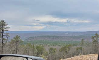
Dispersed camping near Jennings Randolph Lake offers access to the high-elevation ecosystems of Monongahela National Forest, where campers can experience temperatures 10-15 degrees cooler than surrounding lowlands. The region features abundant primitive sites with elevations ranging from 2,500 to 4,000 feet, creating diverse microclimates that support unique plant communities. Weather patterns can change rapidly throughout the day, with morning fog common even during summer months.

What to do

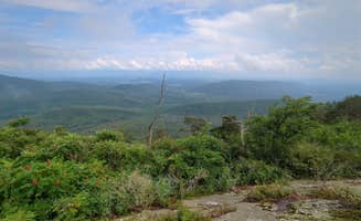
Hiking at Dolly Sods Wilderness: Trek through diverse landscapes resembling northern Canadian environments at Dolly Sods Backcountry. According to one camper, "The ferns and evergreens reminded me of being in Maine, the vast meadows felt like I was in Wyoming or Montana." Another visitor noted, "The rocks on the trail may be a pain, but the formations and views from Raven's Ridge, Lion's Head and Bear Rocks rival the best."

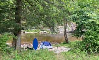
Fishing at Lower Glady: Cast for native trout in streams approximately 5 miles from camp at Lower Glady Dispersed Campground. "Nice camp sites, and good fishing," reports one visitor. Another camper mentioned, "A few friendly fishermen each day, sharing local knowledge."

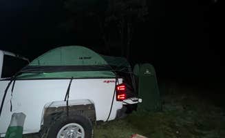
Exploring forest service roads: Drive the scenic backcountry routes connecting multiple camping areas. "We found a nice site in the pine trees! Perfect for 2 vehicles and 5 people hammock camping!" noted one visitor to Canaan Loop Road. These roads offer access to numerous unmarked sites and connect to major trail systems throughout the region.

What campers like

Privacy between sites: Many rustic camping areas near Jennings Randolph Lake feature natural spacing between campsites. At Squirrel Hollow Road Camping, "Large campsites and relatively quite. We took two vehicles and found several suitable sites. Traffic was light with one pickup overnight and a small convoy of motorcycles the next morning."

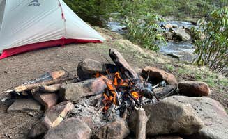
Fire rings and established sites: Despite being primitive, many dispersed sites include stone fire rings. At Wolf Gap Recreation Area, "Most sites have a paved parking platform and then a second tier for the camp site. All sites are quite large and include picnic tables, fire rings and large tent platforms." Another camper at Squirrel Gap noted, "Decent sized area, stone fire ring, plenty of firewood."

Night sky viewing: The minimal light pollution creates exceptional stargazing opportunities. One camper at Lower Glady reported, "There is a wonderful view of the night sky and having the mountain backdrop in the morning was really nice." The higher elevations around many dispersed sites enhance celestial visibility.

What you should know

Road conditions vary dramatically: Access to many sites requires navigating unpaved forest roads. At Canaan Loop Road Dispersed, one camper advised, "Road is easy to drive on- some bumps but we were in a small kia sedan and it was fine." However, another cautioned, "If you come in from the east, it's a very well maintained road for any vehicle (RVs may have trouble turning around), but the last mile or two you need a 4x4."

Weather preparedness essential: The high elevations create unpredictable conditions. One visitor to Dolly Sods warned, "Know that it will likely rain on you in Dolly Sods, so always bring rain gear. Also realize, that with climate and conditions similar to the Canadian Tundra, temperatures and winds vary and fluctuate often, any time of year."

Navigation skills required: Many areas lack clear signage or cell service. A Dolly Sods camper emphasized, "A good physical map and compass, the skills needed to use them, are vital here. There are no trail marks and the path can be confusing."

Tips for camping with families

Look for stream-adjacent sites: Many camping areas feature small waterways perfect for kids to explore. At Wolf Gap, "The campground has vaulted toilet and communal garbage receptical. There is a large day use area. There are several trails that intersect with the campsite and day hikers are a common site."

Pack for muddy conditions: Many sites remain wet regardless of season. One camper at Squirrel Gap Rd Dispersed noted their "entrance is steep" but they found a "decent sized area" perfect for setting up a family camp. Another visitor to Canaan Loop Road mentioned, "All of the sites were mud pits but they were easily identified by big fire rings."

Plan shorter hiking routes: Consider shorter trail segments with younger children. A Dolly Sods visitor recommended, "There are some opportunities to camp closer to the trailhead for those only looking to dip a toe into wilderness travel, but you could hike for miles to a remote site as well."
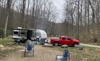
Tips from RVers

Level site challenges: Many primitive sites aren't designed for larger recreational vehicles. At Wolf Gap Recreation Area, a camper observed, "Many of the car parking pads are not level. But the tent pads appear to be." Another noted, "We camped during the week and had nobody else camping on weekdays" at Squirrel Hollow, making midweek visits ideal for finding suitable spots.

Water and waste management: No hookups exist at any dispersed sites near Jennings Randolph Lake. A Squirrel Hollow camper advised, "True boondocking, haul it in, pack it out." For those needing facilities, some areas like Lower Glady offer vault toilets described as "one of the cleanest I have seen" by a recent visitor.

Frequently Asked Questions

Which is the most popular dispersed campsite near Jennings Randolph Lake?

According to TheDyrt.com, the most popular dispersed campground near Jennings Randolph Lake is Canaan Loop Road Dispersed with a 4.8-star rating from 13 reviews.

What is the best site to find dispersed camping near Jennings Randolph Lake?

TheDyrt.com has all 14 dispersed camping locations near Jennings Randolph Lake, with real photos and reviews from campers.