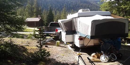
The sound of rushing creek water and rough access roads define the camping experience at Guanella Pass Campground. This Forest Service facility operates from early June through early September at 10,000 feet elevation, where two distinct loops accommodate both RVs up to 45 feet and tent campers seeking creek-side sites.
Four walk-in sites along the creek offer the most space and privacy, positioned directly beside the water with thick tree cover providing natural barriers between campers. Hayley K. notes these creek-side spots are "right on the creek" and provide "beautiful white noise for those that are close to it." The main campground road can deteriorate significantly during wet conditions, with some reviewers reporting near four-wheel-drive requirements for navigation.
Fishing opportunities exist both in the adjacent creek and nearby alpine lakes, while the campground serves as a staging area for Mount Bierstadt hikers. The facility provides vault toilets, potable water, and trash service, with reservations available through the standard Forest Service system. Sites fill quickly on weekends during peak season, though weekday availability remains more reliable.
Road conditions vary considerably based on recent weather and maintenance schedules. Several campers mention mosquito activity during summer months, particularly in July and August when wildflowers bloom throughout the surrounding forest. "Just a short hike either way and you're by the river," observes Sarah M., highlighting the easy water access from most sites.
Campers seeking lower elevation alternatives can consider Clear Lake for a different mountain camping experience.
Description
Overview
Guanella Pass Campground is located about 7 miles south of Georgetown on the South Fork of Clear Creek on the Guanella Pass Scenic Byway. Located at an elevation of 10,900 feet on the Arapaho Roosevelt National Forest, visitors to the campground can also enjoy hiking and fishing in the area. The Guanella Pass Scenic and Historic Byway follows an old wagon route that linked the mining towns of Georgetown and Grant, Colorado.
Recreation
Visitors can go trout fishing on the South Fork of Clear Creek. Silver Dollar Lake is nearby, but cannot be reached by car. Instead, the Silver Dollar Lake Trail leads hikers above treeline to the scenic lake.
Facilities
The campground is split into two loops by the county road and South Clear Creek. There are 18 sites in the campground. Eleven are suitable for RV camping and seven are more suitable for tents. Large RVs are not recommended on the byway. Most of the sites are in the open with some tent sites located among some spruce trees. Each site has a tent pad, picnic table, fire ring and charcoal grill. The roads through the campground are gravel. This facility provides hand pumps with potable water, vault toilets and trash dumpsters.
Natural Features
The Arapaho and Roosevelt National Forests and Pawnee National Grassland sit along the foothills and Rockies of Colorado. The forests and grassland cover 1.5 million acres and extend north to the Wyoming border, south to Mount Evans and west across the Continental Divide. The area includes mountains, lakes and five scenic byways, designated by Congress for their scenery, wildlife or history, including the highest road in North America. Mount Evans Road, also known as Colorado Highway 5, allows visitors to drive from 10,500' to 14,130' above sea level in just 14 miles.
Nearby Attractions
Visitors enjoy touring historic Georgetown, a former mining town of about 1,000 residents. Additional ghost towns dot the region.
Contact Info
For facility specific information, please call (530) 529-0578.
Charges & Cancellations
Modifications for this campground must be made through Recreation.gov or by calling the call center at 1-877-444-6777 PRIOR to your reservation start date. Customers and contact center agents cannot modify reservations on or after the check-in date.
RV Road Trip Guides


Map & DirectionsGuanella Pass is located in Colorado near Silver Plume
Directions
From I-25 in Denver, take I-70 West to Georgetown Exit 228. Go south on County Road 381 (Guanella Pass Scenic Byway) for 9 miles. From Denver take Highway 285 to Grant. Turn right (north) on to Park County Road 62. Drive approx. 14.5 miles to the campground.
Coordinates
39.6127778 N
105.7161111 W
Connectivity
 T-MobileNo CoverageVerified by 1 userLast on 6/30/26
- VerizonNo Coverage
- AT&TNo CoverageVerified by 1 userLast on 6/30/26
Connectivity
- T-MobileNo CoverageVerified by 1 userLast on 6/30/26
- VerizonNo Coverage
- AT&TNo CoverageVerified by 1 userLast on 6/30/26
Access
- Drive-InPark next to your site
- Walk-InPark in a lot, walk to your site.
- Hike-InBackcountry sites.
Site Types
- Tent Sites
- RV Sites
- Standard (Tent/RV)
- Group
- Equestrian
Features
For Campers
- Trash
- Reservable
- Drinking Water
- Toilets
- Alcohol
For Vehicles
- Big Rig Friendly
Drive Time
- 1 hr 39 min from Denver, CO
- 1 hr 49 min from Boulder, CO
- 2 hrs 25 min from Fort Collins, CO
- 2 hrs 27 min from Colorado Springs, CO


