Dispersed camping near Picacho, Arizona centers on the Ironwood Forest National Monument, where summer temperatures frequently exceed 100°F between May and September. The area's Sonoran Desert landscape ranges from 1,800 to 4,200 feet in elevation and contains one of the densest saguaro forests in Arizona. Winter temperatures drop to the 40s at night, creating the most popular camping season from October through April.
What to do
Sunrise wildlife viewing: Wake early at Cactus Forest Dispersed to catch desert animals in their active hours. "We enjoyed waking up to the literal forest of cactus," notes camper Emma A., who found the site "quiet and peaceful" for morning nature observation.
Desert hiking: Explore the terrain on foot during winter months when temperatures remain moderate. At BLM Pipeline Rd, a visitor reports, "Location of this site is optimal - about five minutes from a local mart with all essentials, and ten from a Speedway and Dollar General. About 35 minutes from Saguaro West/Mountain Park and the same into central Tucson."
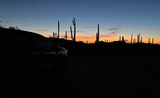
Night sky photography: The minimal light pollution makes primitive camping near Picacho excellent for astrophotography. According to one camper at Cactus Forest, "Unreal sunsets too," with another mentioning "excellent stargazing" conditions after dark.
What campers like
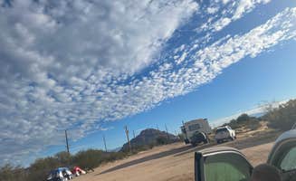
Desert privacy: Many dispersed sites offer natural separation. At Cactus Forest Dispersed Site, Suzie K. notes, "The cactuses and shrubs provided enough privacy between each site for it to feel like it was just us out there, and shielded us from the road as well."
Accessibility: Multiple roads provide various access points for different vehicle types. At Ironwood Forest BLM, Susan C. reports, "There are a few good rolling bumps and small ditches but going slow will help. Plenty of areas to pull into, some are ez in and out loops, some are back-ins."
Diverse terrain: The landscape varies across the primitive camping areas near Picacho. "The Saguaro cactus are huge and impressive. We really enjoyed driving through this area at sunset and seeing all the iconic cactus," shares a visitor, highlighting the distinctive vegetation that characterizes the region.
What you should know
Fire restrictions: Check current fire regulations before arrival as restrictions vary seasonally. Kevin C. at Cactus Forest notes, "Came in for a three night stay in February. Weather was great, other campers were very respectful of your personal space and found lots of firewood within 100 meters of the campsite."
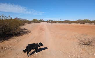
Road conditions: Access roads deteriorate the farther you travel from main entrances. According to Angela G. at Pipeline Rd BLM Camping, "Road is mostly very flat but does have the occasional bump/washout, and there is no shortage of rocks."
Target shooting: Be aware that recreational shooting occurs in designated areas. Kelly S. comments, "I may have heard some shooting, but, it was so far off I couldn't be sure and it was rare."
Local wildlife: Watch for native wildlife, particularly after dark. Coyotes, bobcats, and reptiles are common throughout the area, especially during spring and fall when temperatures are moderate.
Tips for camping with families
Cactus safety: The abundant cholla cacti require vigilance with children. As Suzie K. advises, "Watch out for cactus pieces on the ground when you drive in!" Another camper specifically warns, "It's incredibly prickly everywhere. Imagine that, prickly in the cactus forest? You'll want to avoid wearing sandals too."
Educational opportunities: Turn desert camping into a learning experience at Redrock Trail Head Dispersed. Jonathan E. mentions, "This is a nice spot to camp, whether it just be an overnight or for multiple days. It was peaceful and serene when I visited in April, with very few people around."
Weather planning: Schedule family trips during moderate temperature months. Cris B. at Ironwood Forest notes, "The road from the highway is paved for most of the way. It is about 7 miles from I-10 north of Tucson."
Supply runs: Plan for self-sufficient camping but note proximity to supplies. Several campers mention convenience stores within 5-10 miles of most primitive camping areas near Picacho.
Tips from RVers
Site selection: Arrive during daylight to properly assess sites. "We parked one of the closest open spots to the main Silverbell Road. It was far enough away from Silverbell that I really had to focus to hear anyone driving down that road," says Kelly S., highlighting the importance of strategic positioning for a quieter experience.
High-clearance needs: Some roads require careful navigation. As Silas T. cautions, "Dispersed BLM camping folks the main road in has a pretty good little drop-down I wouldn't take a big rig past the first area on the right there's some pretty good dips in the main road going further back."
Seasonal considerations: Winter provides the most comfortable camping conditions. "Weather was a bit warm on some of the days (87 - 90), but, we are use to very hot days in Phoenix, so, mostly tolerable for us in the shade," reports Kelly S., indicating the importance of shade structures in warmer months.
Generator etiquette: While generators are permitted, respect neighboring campers. Across all dispersed camping areas near Picacho, maintaining distance between sites helps reduce noise impact.


 Guide
Guide