

P
Paul R. Scout
Scout
White Tank Mountain Regional Park
Nice quiet retreat!
Very nice smaller campground that was clean and well kept. It was very hot so not much outside activity. Will definitely be back this fall!
61 campgrounds · Check availability for any dates.
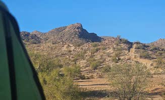
The small town of Gila Bend sits in the middle of the Sonoran Desert, where camping near Gila Bend ranges from full-hookup RV parks to primitive desert campsites. Campers can stay at Sonoran Desert RV Park, which has full hookups and basic but clean bathrooms. Family Campground has bigger sites with tables and fire rings, good for groups with kids. At Painted Rock Petroglyph Site and Campground, you can camp near ancient rock carvings in a quiet setting away from town noise. The desert around Gila Bend has its own beauty, and the Colorado River isn't too far for swimming or fishing when you need a break from the heat. Some campers use Gila Bend as a stopping point before heading north to see the Grand Canyon. Winter and spring are the best times to visit since you can hike without overheating. Summer temperatures regularly hit triple digits, so morning and evening are the only reasonable times to be outside. Most camping spots here are pretty basic, so bring what you need from larger towns. Phone service drops in and out depending on where you camp. The night skies above Painted Rock are incredibly dark, letting you see stars that disappear near cities. RVers often choose Sonoran Desert RV Park when they need to recharge batteries and fill water tanks. Gila Bend camping works well for history buffs, desert walkers, and anyone who needs a quiet place to stop — making the campgrounds near Gila Bend a practical and rewarding base for exploring the western Sonoran Desert.
"We have stayed at many KOA from Arizona to Montana to Illinois and this one is by far the best!! We have even stayed at KOA Holiday level facilities that cost much more and were not as nice."
"As a result, this location is taking diligent steps to avoid exposure and transmission. All common areas are closed and they’ve created a social distancing system for their business."
from $38 - $70 / night
Check Availability"BLM Painted Rocks Petroglyphs Campground. 26 miles west from Gila Bend. Very large campground about a third of sites can be reserved online at recreation.gov."
"Close to Gila Bend. There is a great paved road to this remote spot. Every spot has a table and a fire pit."
from $8 / night
"Lots of room to spread out and be away from neighbors if that’s your thing"
"Instead of staying under the power lines like many people mentioned (and indicated by the app), we drove a little bit further away from the main road and found a perfect spot for an overnight stay on our"
"Nice campground all sites are pull thru laundry mat is free but nothing around for miles"
from $20 - $25 / night
Check Availabilityfrom $8 / night
Check Availability"It’s mostly flat we tucked up behind a tree but it was closer to the road so we did hear the road often. There are also train tracks that pass through but the train rumble wasn’t too bad"
"Beautiful view, a little close to the interstate but quiet enough to sleep. I will stop here again"

Very nice smaller campground that was clean and well kept. It was very hot so not much outside activity. Will definitely be back this fall!
The entrance is covered in small bushes/trees. Go down road to West to main Sonoran desert monument entrance. Wide open and can accommodate all rigs.
I came at a terrible time. It was WAAAAAAYYYYYY too hot for me! Little to no tree coverage for shade, run down, broken pop up and resident tent camper where we camped and the smell of sewage is horrifying at times, it wakes me up in the middle of the night. HOWEVER, the park employees are absolutely lovely, I love the emus and chickens and turkeys and peacocks and all the beautiful birds (although I did find 2 dead ones.) The women's bathhouse is pretty clean and the sky is so beautiful in this part of the country. And the price is right. If I could do it again, I'd probably only want to come here in Nov-April, not May. 🔥🥵🔥
Wonderful RV park, off the beaten path. Scott was very helpful getting us settled in and showing us where everything was. It was so quiet and dark at night. We sat outside and stared at the sky for so long just enjoying the stars. We would love to go back and stay longer.
A very large park with lots of day sites. Plenty of pavilions for group use. Lots of trails for all skill sets. Great for bikes. Horse trails. Water and electric sites with a dump station. My site was backwards for my trailer but was still good.
Easy drive, no one here, loads of stars at night.
The freeway is on one side, trains on the other. If you’re trying to escape freeway noise, it might be a bit challenging. Trains run past regularly but they’re not too noisy. The sites are older, not very level and the electric connections are definitely worn. The water tastes “thick” like it’s soft water but it isn’t. The RV sites are full hookup with 20/30/50 amp service.
Easy access with turn lanes from both directions to enter. Spots are spaced out nicely. Typical desert landscape with nice scenery.
First time at the location but invited a couple of ladies for the adventure. Got to location but were not given any instructions. Before the end, the host started beating on the door stating others were there for the same location. Lack of communication ruined the experience and cause embarrassment. They should update website. Most of information is outdated and or incorrect. Temperature of water close to 70 degrees not 100 as quoted on site..I wouldn't spend anymore money there. The guy, Tello was pleasant but couldn't make up for the lady with the bad attitude.
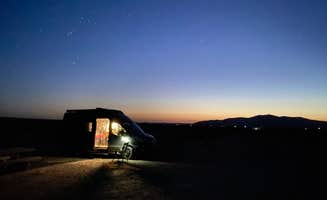
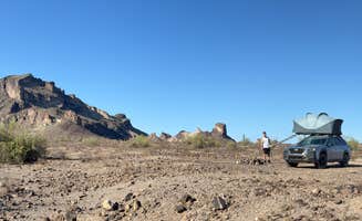
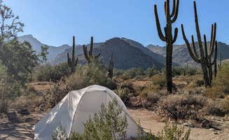
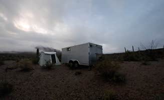
Dispersed camping options spread across the desert landscape surrounding Gila Bend, Arizona. Located at just 700 feet elevation, this region can reach daytime temperatures of 115°F during summer months. Several access points exist for boondocking on BLM land within 30 minutes of town, offering different levels of isolation and amenities depending on how far travelers venture from highways.
Rock art exploration at Painted Rock: Take a short, accessible trail around the concentrated rock pile featuring hundreds of ancient petroglyphs. "The Petroglyphs are awesome but not much else going on here. Stay a night and see it all in 15 minutes," notes Dave B. from Painted Rock Petroglyph Site And Campground.
Desert driving adventures: Multiple BLM roads provide access to remote camping with varying degrees of difficulty. Greg L. recommends caution on some routes: "This is a two track road that leaves Interstate 8 at about MP 124. There are no signs and EXTREME CAUTION is advised trying to access these BLM roads from the freeway without an exit ramp. No TTs or RVs are recommended."
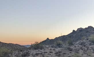
Night sky observation: The dark skies in this region provide excellent stargazing when moon brightness doesn't interfere. One camper at Painted Rock notes, "Great spot for star gazing I imagine when the moon isn't quite so bright." The distance from major light pollution creates optimal viewing conditions during clear nights.
Budget-friendly options: Free or low-cost camping appeals to many visitors passing through. James B. shares about Painted Rock Petroglyph Site: "Sites are gravel and all pretty level. We like exposure for solar, which was good because there is no shade. Pit toilets and trash dumpsters. No water or dump. Quiet at night. $8 a night is a good deal."
Dog-friendly facilities: Several campgrounds accommodate pets with special amenities. "We stayed in a deluxe pull-through for two days. Our site has a small fenced-in play area for our mutt," reports Robert & Diane M. about their stay at Sonoran Desert RV Park.
Solitude and space: Most dispersed camping spots offer significant distance between sites. A camper at North Maricopa Mountains Wilderness observed: "This is pretty much like the reviews say, your basic BLM undeveloped dispersed camping area... This is also a popular ATV area which comes with a lot of dust and noise."
Summer heat constraints: Triple-digit temperatures limit outdoor activities during summer months. One visitor to Margie's Cove West Campground warns: "Sight is nice and deep in the Cove. The drive is not hard but it has its bumps... The spot is very secluded and in a big wide open valley. Really windy during the day."
Vehicle limitations: Many dispersed camping spots require appropriate vehicles. Greg L. cautions: "Overlander types recommended. This two-track BLM road leaves from the westbound lanes of Interstate 8. EXTREME CAUTION is advised and TTs and RVs are not recommended for these unmarked two tracks along the Interstate."
Bug issues: Flies can be problematic in certain areas depending on season and proximity to livestock operations. "When I left the Margie Cove area, I crossed over 85 on Woods Road to old US 80... I found the source of the flies. There is a huge cattle stockyard about 2 miles from Woods Road," reports one camper.
Highway and train noise: Some camping spots near Gila Bend experience noise from transportation corridors. Fernando C. describes one site: "It's mostly flat we tucked up behind a tree but it was closer to the road so we did hear the road often. There are also train tracks that pass through but the train rumble wasn't too bad."
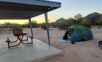
Off-peak timing: Schedule family visits during winter or early spring for comfortable temperatures. Gary H. notes: "Nice warm, peaceful place in December. Great space and privacy. Friendly Camp host a plus. Big flat easy come easy go sites. First come first serve. Bring your own water and electric."
Kid-friendly activities: Some RV parks offer recreational amenities for children. Lee D. shares about Sonoran Desert RV Park: "OK, talk about a hidden gem. This is it really well put together Pool that feels like a therapy pool and huge rv spaces. There's a pickle ball court, there's everything you could possibly want."
Supply planning: With limited services available, families should stock up before arrival. "Gila Bend has a Family Dollar and a couple of small grocery stores plus eating establishments. You're about 30 minutes from major amenities in Buckeye and an hour from Phoenix," explains one reviewer.
RV park amenities: Full-service options exist for those needing hookups. MickandKarla W. details: "Check-in was quick, and we were escorted to back-in site 503 with FHUs. The sites here are long and wide enough for our 40' fifth wheel and F450 truck. The sites in our area were also decently spaced for a private CG. There was also room for an OHV if we'd brought one."
Electrical considerations: Some camping spots near Gila Bend have power infrastructure that requires attention. One camper warns: "One difference are the powerlines overhead that emit a cracking and rattling noise constantly. Not sure of the health implications of those powerlines."
Overnight convenience: Many RVers use camping spots near Gila Bend as quick stopover locations. "We stopped here for an overnight on our way back from San Diego. We did book it online at the last minute while driving on interstate 8, but what we found is a hidden gem and we are already planning on coming back," shares Robo A.
Frequently Asked Questions
What is the Gila Bend FamCamp and what amenities does it offer?
Gila Bend FamCamp is a military campground located near Gila Bend, Arizona, primarily serving active duty, reserve, and retired military personnel and their families. The FamCamp offers drive-in access with reservable sites, water hookups, and toilet facilities. It's designed to accommodate big rigs, making it suitable for larger RVs and motorhomes. The campground provides a convenient stopping point for military travelers in the area, offering more amenities than the surrounding dispersed BLM options while maintaining affordable rates for eligible campers.
What RV parks are available in Gila Bend, AZ?
Gila Bend offers several RV accommodation options. Palms Mobile Home RV Park is located within the town, though some travelers report mixed experiences with comfort and amenities. For those seeking full hookups and more amenities, Sonoran Desert RV Park provides another option in the area. Additionally, just about 26 miles west of town, RVers can find more basic accommodations at the budget-friendly BLM-managed sites, though these typically lack water and RV dump stations.
What camping is available near Gila Bend, AZ?
According to TheDyrt.com, Gila Bend, AZ offers a wide range of camping options, with 61 campgrounds and RV parks near Gila Bend, AZ and 22 free dispersed camping spots.
Which is the most popular campground near Gila Bend, AZ?
According to TheDyrt.com, the most popular campground near Gila Bend, AZ is Sonoran Desert RV Park with a 4.9-star rating from 20 reviews.
Where can I find free dispersed camping near Gila Bend, AZ?
According to TheDyrt.com, there are 22 free dispersed camping spots near Gila Bend, AZ.
Keep Exploring