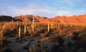
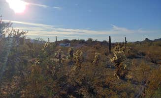
Primitive camping near Gila Bend, Arizona features extensive Bureau of Land Management territory across the Sonoran Desert with elevations ranging from 800 to 1,400 feet. Summer temperatures regularly exceed 110°F while winter nights can drop below 40°F. The desert pavement terrain consists primarily of rocky, sandy soil that becomes challenging to navigate after rainfall.
What to do
Rock collecting excursions: The Vekol Valley area contains numerous geodes and other interesting geological specimens. As one camper noted at BLM Sonoran Desert National Monument - Vekol Road Dispersed Camping Area, "Tons of geodes and other cool rocks, tons of space to walk and explore."
Wildlife observation: Early mornings and evenings offer the best opportunities to spot desert wildlife. A visitor at Vekol Valley Road shared, "I saw a jackrabbit or something similar right after dusk, so there is at least some small wildlife in the area."
Off-highway vehicle recreation: Some areas permit ATV use on designated trails. At North Maricopa Mountains Wilderness, a camper observed, "This is also a popular ATV area which comes with a lot of dust and noise and rude people."
Bushwhacking hikes: The open terrain allows for creating your own hiking routes. A visitor to Vekol Road mentioned, "We bushwhacked 2 mile loop Southeast to a big wash," demonstrating the area's potential for self-guided exploration.
What campers like
Desert solitude: Despite proximity to Interstate 8, campers can find quiet spots away from the highway. At Sonoran Monument Dispersed Camping, visitors report: "If you follow the road in enough the train isn't bothersome. Fun rocks around, quiet and not many other campers."
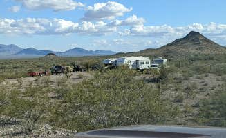
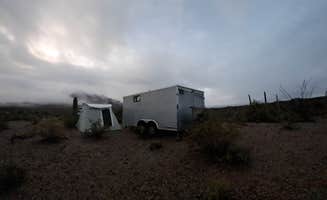
Open camping layouts: The dispersed nature means campers can spread out. At Vekol Valley Road, a reviewer noted: "There are quite a few pull-outs on the road with sites and there is enough brush in the area to feel pretty secluded."
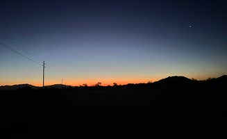
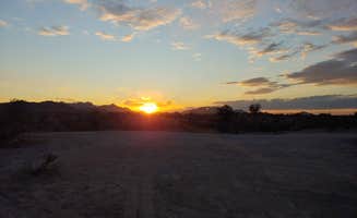
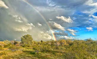
Night sky viewing: Limited light pollution creates exceptional stargazing conditions. According to one camper at Vekol Valley Road: "The views were phenomenal and very little noise. The moon and stars were beautiful too."
Diverse camping zones: Multiple access roads create varied experiences. A camper at Saddle Mountain BLM shared: "As soon as you turn off of W Salome Hwy on to W Courthouse rd you'll find at least 9 or more entrances that lead up towards the mountain."
What you should know
Vehicle considerations: Many roads deteriorate significantly beyond the first mile. As one visitor to BLM Sonoran Desert National Monument - Road #8030 Access warned: "The road gets rougher and crosses many sandy washes so high clearance 4x4 is a good idea."
Interstate access hazards: Several BLM roads connect directly to Interstate 8 without proper exits. A reviewer cautioned: "Note that the exit from the interstate is very risky and EXTREME Caution is advised...check your rear before you slow down to leave the interstate pavement."
Overhead power lines: Some camping areas have electrical infrastructure overhead. A North Maricopa Mountains Wilderness camper reported: "One difference are the powerlines overhead that emit a cracking and rattling noise constantly. Not sure of the health implications of those powerlines."
Weather challenges: Wind conditions change rapidly and bring environmental issues. At Saddle Mountain BLM, one camper warned: "Flies are horrendous out here, no matter what you try to do to keep them away or out it's almost impossible to do!"
Tips for camping with families
Choose less remote locations: For safety with children, stay closer to main access points. A visitor to Vekol Valley Road shared: "Easy in and out of 8 West on Vekol Rd. 3 other campers when we arrived. Our closest neighbor stopped by to help us and introduce himself, Jeff. That was nice of him."
Scout for wash hazards: Desert washes can be dangerous for children. At North Maricopa Mountains Wilderness, a camper warned: "Beware of paths that seem fit for a two wheeled vehicle but were created by ATVs which can often climb into and out of these washes with no problem."
Prepare for temperature extremes: Desert camping requires additional precautions with children. A summer visitor to North Maricopa Mountains Wilderness Area noted: "It was super hot and no breeze at all. We arrived by 8pm and left 4:30am."
Plan supply runs carefully: Services are limited and distant. A camper at Vekol Valley Road mentioned: "It's a little too quiet and remote. 45 min. To stores in Maricopa, AZ."
Tips from RVers
Trailer access limitations: Many roads have challenging features that restrict larger rigs. A North Maricopa Mountains Wilderness visitor cautioned: "As one reviewer mentioned there are washers that could hang up many large and even midsize rigs."
Advanced scouting recommended: Check routes before committing with larger vehicles. One experienced RVer advised: "Like any time your looking for a site, park in a safe place and search by either foot or in my case ebike."
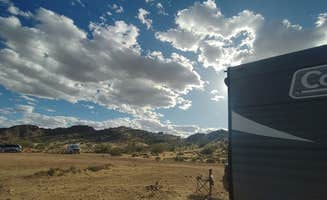
Site selection strategy: Bigger rigs should focus on specific areas. At Saddle Mountain BLM, a camper noted: "Sites here can accommodate the big rigs, but the smaller you are the more options you have."
Road condition awareness: Terrain changes seasonally impact accessibility. According to a visitor at Vekol Valley Road: "Road was a nice gravel with no ruts. Plenty of spots to choose."


 Legend