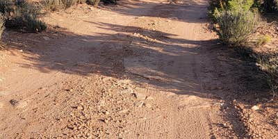
Free dispersed camping on Gooseberry Mesa starts with a commitment: several miles of washboard dirt road before you reach the sites. Reviewers consistently flag the approach as rough enough to rattle vehicles and gear, though one group made it through towing a utility trailer without high clearance. The road smooths out somewhat after the turn toward the mesa. Vault toilets are available at both trailheads, but there is no water on site, so campers need to arrive self-sufficient.
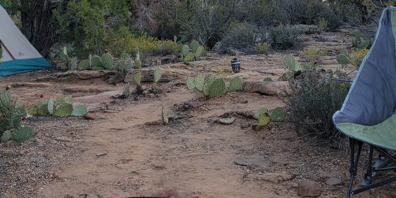
Once on the mesa, sites are spread across the plateau with open sightlines toward Smithsonian Butte and the sandstone formations to the east. Several established spots include fire pits and level ground. As Dave B. puts it, sites are "fairly level with great views." Sunsets draw consistent attention from reviewers, with alpenglow on the surrounding sandstone a commonly noted feature. The area stays relatively uncrowded, though mountain bikers use the mesa trails regularly and are part of the scene.
Navigation deserves attention before the drive out. Apple Maps has led at least one visitor astray. The coordinates 37.13225° N, 113.13171° W have been flagged as reliable. Ignore any trespassing signs near what appears to be a campsite on Google Maps and continue on the Whitewash Road until established sites appear. Cell coverage is solid once you arrive, with multiple reviewers reporting strong signal on AT&T, T-Mobile, and Verizon, including speeds around 20 Mbps.
Gooseberry Mesa sits within BLM land managed by the St. George Field Office, and campers exploring the broader area can find campgrounds near BLM Land — St. George Field Office if the mesa sites are occupied. Nearby alternatives include Gooseberry Mesa Grafton Road Dispersed — BLM St. George and Gooseberry Mesa Campground - Dispersed, both within a mile. Zion National Park is roughly an hour away, making this a workable base for a longer southern Utah itinerary. Bring extra water, a full tank of gas, and a tire repair kit given the road conditions.
Description
Gooseberry Mesa and Hurricane Cliffs trails are located in southern Utah’s red rock country. Views from the mesa rims along these trails are spectacular. To the north are massive sandstone sentinels of Zion National Park. Spread out below the west rim is a panorama of colorful desert mesas and water carved canyons. These trails are designed to provide technically challenging mountain bike opportunities. Single track and slickrock wind across the mesa top in a series of interconnected trails providing a unique setting that will provide a high quality experience to all types of mountain bikers. One of the Bureau of Land Management's "Backyard to Backcountry" treasures, information on the Gooseberry Mesa Trail was developed between IMBA and the St. George, UT, BLM office to provide world-class riding experiences. IMBA's data on the trail includes elevations, ratings, current conditions, photos, and comments.
RV Road Trip Guides

Map & DirectionsGooseberry Mesa is located in Utah near Rockville
Directions
Hurricane Hills Trailhead: From Interstate 15 Exit 16, head east on State Route 9 to Hurricane City for 9.5 miles. Turn right on Main Street. Take the first left onto State Route 59 and at 0.75 miles turn left into the trailhead. (To reach Canal Trail, hike 1.8 miles on the Rim Trail before turning left onto the Canal Trail.)
Coordinates
37.14055848 N
113.149115 W
Connectivity
 T-Mobile5GExcellent CoverageVerified by 9 usersLast on 7/24/26
 VerizonLTEGood CoverageVerified by 24 usersLast on 7/24/26
- AT&T5GExcellent CoverageVerified by 6 usersLast on 7/24/26
Connectivity
- T-Mobile5GExcellent CoverageVerified by 9 usersLast on 7/24/26
- VerizonLTEGood CoverageVerified by 24 usersLast on 7/24/26
- AT&T5GExcellent CoverageVerified by 6 usersLast on 7/24/26
Access
- Drive-InPark next to your site
- Walk-InPark in a lot, walk to your site.
Site Types
- RV Sites
- Dispersed
Features
For Campers
- Phone Service
- Alcohol
- Pets
- Fires
DISPERSED CAMPING
Enjoy dispersed camping on government land and leave no trace. Pack in and pack out. No (or limited) services at this camping area. Permit may be required.
PERMIT might be REQUIRED
We curate permit requirements across the US for our PRO members. Try PRO to see if Gooseberry Mesa needs a permit.
Drive Time
- 28 min from St. George, UT
- 2 hrs 10 min from Las Vegas, NV
- 3 hrs 43 min from Flagstaff, AZ
- 4 hrs 55 min from Prescott Valley, AZ


