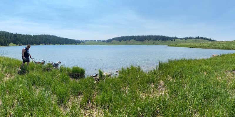
Within White River National Forest, Deep Lake operates as a high-elevation campground at 10,500 feet, accessible via a 10-mile dirt road that can damage tires in rough sections. The Forest Service manages this established campground from July through September, offering sites that accommodate RVs up to 35 feet alongside tent camping options.
Sites range from open and exposed to forested locations with natural shade. Each includes a metal fire pit with cooking grill, and vault toilets serve the campground area. The adjacent lake provides fishing opportunities with annual Forest Service stocking, while the surrounding Flat Tops Wilderness offers hiking trails and off-road vehicle access. At this elevation, temperatures drop significantly even during summer months.
RV Road Trip Guides


Location
Public CampgroundDeep Lake is located in Colorado
Directions
From Gypsum, CO, take Interstate 70 west and go 5.3 miles to Exit 133, Dotsero, CO. At end of exit ramp, go north on Frontage Rd. for 0.8 miles to a stop sign and Sweetwater/Burns sign (County Rt. 301). Turn Right at sign onto Rt. 301 and go 1.7 miles to Forest Access sign. Turn left at sign onto dirt and gravel road (later identified as Forest Rt. 600) and go 27.6 miles to a "Y" intersection. Bear right, staying on Rt. 600, and go 1 mile to campground sign. Bear right at sign and go 0.1 miles into campground.
Coordinates
39.77200029 N
107.3020004 W
Connectivity
 T-MobileNo Coverage
- VerizonNo Coverage
- AT&TNo Coverage
Connectivity
- T-MobileNo Coverage
- VerizonNo Coverage
- AT&TNo Coverage
Access
- Drive-InPark next to your site
- Walk-InPark in a lot, walk to your site.
- Boat-InSites accessible by watercraft.
Site Types
- Tent Sites
- RV Sites
- Standard (Tent/RV)
- Group
- Tent Cabin
Features
For Campers
- Reservable
- Drinking Water
- Toilets
- Alcohol
- Pets
- Fires
Drive Time
- 2 hrs 4 min from Grand Junction, CO
- 3 hrs 17 min from Denver, CO
- 3 hrs 27 min from Boulder, CO
- 4 hrs 2 min from Fort Collins, CO


