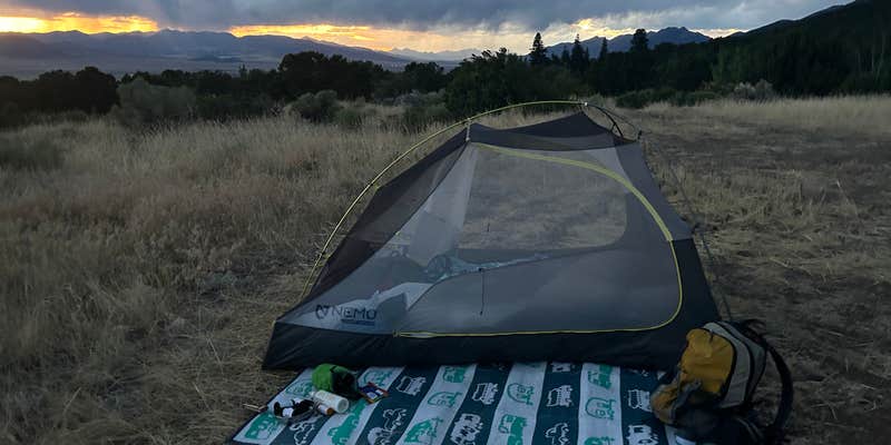
Stargazers find exceptional dark skies at this free dispersed camping area along Forest Service Road 64. The rough, rocky access road requires slow speeds for the final mile, but campers with standard clearance vehicles can navigate the route by avoiding private roads and following the side road to multiple camping spots.
At least ten dispersed sites spread along the road, with three positioned directly beside Cotton Creek and all featuring established fire rings. The elevation and open terrain create conditions where wind settles after dark, revealing expansive star fields. Campers can access camping near Crestone for additional options, and the location sits just five miles from Valley View Hot Springs for day pass holders. The combination of creek access, fire-friendly sites, and exceptional night skies makes this spot well-suited for campers prioritizing astronomy and solitude over amenities.
Description
The Cotton Creek Trail is 13.1 miles long. It begins at Forest Road 962 and ends at Forest Trail #745. Trail is well marked and maintained. It follow the creek through a rugged, steep canyon and diverse scenery, with views of high peaks and many beautiful wildflowers in season. Some stream crossings can be tricky if water level is high. Attractions are fishing in creeks and lakes, and many good campsites. Teacup Lake presents an opportunity for primitive route finding.
The trail is open for the following uses: Hiking, Backpacking, Horseback Riding, Dispersed Camping, and Wildflower Viewing
RV Road Trip Guides


Map & DirectionsCotton Creek Trailhead is located in Colorado near Crestone
Directions
From Alamosa travel on Highway 17 to county road AA, travel east for 5 miles, turn north on gravel road for 2 miles, turn east, travel 2 miles to trailhead.
Coordinates
38.13157442 N
105.7872448 W
Connectivity
 T-MobileNo CoverageVerified by 4 usersLast on 7/28/26
 VerizonLTESome Coverage
- AT&TLTESome Coverage
Connectivity
- T-MobileNo CoverageVerified by 4 usersLast on 7/28/26
- VerizonLTESome Coverage
- AT&TLTESome Coverage
Access
- Drive-InPark next to your site
- Walk-InPark in a lot, walk to your site.
Site Types
- Tent Sites
- RV Sites
- Standard (Tent/RV)
- Dispersed
- Group
- Equestrian
Features
For Campers
- ADA Access
- Phone Service
- Alcohol
- Pets
- Fires
For Vehicles
- Big Rig Friendly
DISPERSED CAMPING
Enjoy dispersed camping on government land and leave no trace. Pack in and pack out. No (or limited) services at this camping area. Permit may be required.
Drive Time
- 2 hrs 30 min from Pueblo, CO
- 2 hrs 51 min from Colorado Springs, CO
- 3 hrs 16 min from Denver, CO
- 3 hrs 26 min from Boulder, CO


