Best Dispersed Camping near Casa, AR

CAMPER SUMMARY PRESENTED BYFord

The Ouachita National Forest offers several free dispersed camping options near Casa, Arkansas, primarily along Forest Service roads 132 and 153. These primitive sites typically feature rock fire rings but no amenities—no toilets, water, or trash service. Forest Road 132 provides the most accessible spots, with some sites offering mountain views and occasional cell service. One camper noted, "Large site if you are sleeping on the ground bring plenty of padding it is rocky and not very flat."

Road conditions vary significantly throughout the area. Many forest roads suffer from erosion and washouts, particularly after heavy rains. FR153 has been described as "way too washed out" with "drainage pipes exposed," making it accessible only to high-clearance 4x4 vehicles. Brown Creek Road (FR805) hosts several popular sites including the Brown Creek Cascade area, where visitors appreciate the "soothing sound from the creek." Most dispersed sites can accommodate tent camping and smaller vehicles like truck campers or vans, though leveling may be required on the rocky terrain. Fire restrictions may apply seasonally, so visitors should check current regulations before traveling.

Map showing campgrounds near Casa, ArkansasExplore the Map

Best Dispersed Sites Near Casa, Arkansas (50)

Show More
Showing results 1-10 of 50 campgrounds

2025 Detourist Giveaway

Presented byToyota Trucks

Review Campgrounds. Win Prizes.

Enter to Win


Dispersed Camping Reviews near Casa, AR

61 Reviews of 50 Casa Campgrounds


  • Fred S.The Dyrt PRO User
    Feb. 12, 2022

    Dispersed FR132 Ouachita National Forest, AR

    Dispersed Camping near Ouachita National Recreation Trail, AR

    Located along Forest Road 132 (Winona Scenic Drive) in the Ouachita National Forest, Saline County, Arkansas. Flatside Wilderness Area located across the road from the site. Access to the Ouachita National Recreation Trail located nearby. Free dispersed site, no facilities. Rock fire ring. Should be enough parking for 2 vehicles. Suitable for tent camping, car camping, truck camping & van camping. Mostly level. There was plenty of firewood left by the fire ring. Camped here in February; very quiet. Only 2 vehicles drove by. Had a few bars of T-Mobile service.

  • Fred S.The Dyrt PRO User
    Jan. 14, 2022

    Brown Creek Cascade Dispersed Campsite

    Free dispersed camping in the Ouachita National Forest

    Popular dispersed campsite in the Ouachita National Forest. Only one site; not a campground. Located on the gravel Brown Creek Road in Perry County, Arkansas. The South Fork of Brown Creek runs behind this campsite. Located next to the trailhead for Brown Creek Cascade - a short 1/4 mile hike (includes a creek crossing). This campsite is suitable for tent camping, car camping, camper vans & truck campers. Two vehicles can easily fit on this level site. There are other dispersed sites along Brown Creek Road. The site is close to the road; there's a large mud puddle covering one of the 2 entrances to this site. 2-wheel drive passenger cars can make it to the site. Large pine trees on the site. Hammock camping is possible. No water (except for creek). No toilets nor showers. No trash - take out what you bring in. May need to hike a ways in the woods to find firewood. Large rock fire ring on site. No AT&T and T-Mobile cell service. Very quiet; no vehicles passed by during the night. The sound from the creek was soothing.

  • Fred S.The Dyrt PRO User
    Jul. 7, 2024

    Brock Creek - Charleston Rd Dispersed, Ozark NF, AR

    Nice Dispersed Site Above Brock Creek

    Not sure if the location pin is correct, so here are the coordinates: 35.49995, -92.80930. A large, wooded dispersed site situated above Brock Creek off of Charleston Road in a popular national forest OHV and multi-use trail area. Charleston Road is a wide, well maintained gravel road. The dispersed site can accommodate 2 or 3 vehicles - campervan size and smaller. There are 2 access driveways into the site. Access for a truck camper is tight due to the location of trees on the site. Access for 2WD low clearance vehicles may be rough due to some erosion. The dispersed site is a dirt surface with some embedded rocks jutting out. Some leveling may be required depending where the rig is parked. Tent camping is possible. There is a vehicle turnaround at the rear of the site. The site is shaded, so solar charging is limited. Except for a little bit of glass and some bullet shell casings scattered about, the site was clean at the time of my visit. The site has a large rock fire ring. There is a wide track that leads off the site toward the south along and above the creek. This track does not appears on any of the current forest service maps (including MVUM) that I have, so I'm assuming that it is not a legal motorized vehicle track. The track is hikeable. The site is convenient to OHV and multi-use trails. It was a pretty site during my summertime visit, but I bet it's beautiful during the Fall season. It is set back from Charleston Road. It is a really nice spot.

  • Fred S.The Dyrt PRO User
    Apr. 23, 2025

    Brown Creek Rd/FR805 Dispersed

    Nice wooded dispersed site above a small creek

    Coordinates: 34.87057,-92.89844. Camped here on April 20, 2025. Located along Brown Creek Road (Forest Road 805), appoximately 1/2 mile west of the Brown Creek Cascade dispersed site and trail head (see separate listing). Large, level site with a dirt surface. Should easily accomadate 2 or 3 rigs and tents. Recommend campervan and smaller rigs. Due to the trees on the site, a truck camper will have a difficult time pulling all the way into the site (although it can park on the access driveway). Easy access from the forest road. The site is clearly visable from the forest road; no privacy, and dust may be an issue during the dry season. Only 6 vehicles passed by during my stay (which was on a Monday evening). There is a large, nicely constructed rock fire ring on the site; other than this, there are no amenities at the site. A small creek is down the hill behind the site; the creek is dry during the dry season. A beautiful wall of trees is across the creek. The site is shaded; solar charging and Starlink connectivity may be difficult. Hammock camping is possible. No T-Mobile cell service. No access to hiking trails at the site; trailheads for Brown Creek Cascade and the Ouachita National Recreation Trail are a short drive away. Loved this site. Peaceful at night. The only sounds came from the birds, the breeze and the creek. Note that due to recent severe Spring storms, portions of Brown Creek Road have some erosion. The rocky surface is moderately rough in places, although a 2WD passenger car can make it if driven carefully through the rough spots. No issues for high clearance 4x4 vehicles.

  • Fred S.The Dyrt PRO User
    Jan. 6, 2025

    FR1802A, Meadows Knob Rd Dispersed

    Secluded, Light Usage, Dispersed Camping in the Ozarks

    Coordinates: 35.58695,-93.20723. Camped here Dec 29, 2024. Set well off of Meadows Knob Rd. Expect pinstriping along the access track to this secluded dispersed campsite. FR1802A toward the site has some erosion; low clearance vehicles may high center in one or two spots. The main forest road into this part of the Ozark National Forest is okay. The campsite is in open area, located in an old clear cut area. There is a partial view of the distant mountains. The site is a level, dirt surface. Not a large site; okay for one rig. Tent camping possible. No nearby mature trees for hammock camping. The site is overgrown with grass and weeds; a weed whacker is needed to clear the rock fire ring. There is a spot on the ground where a previous campfire was made. Good AT&T and T-Mobile 5G service. No shade; access to Starlink is possible. No hiking trails, although there is a 2-track for hiking that leads down into Graves Creek Canyon and some unnamed waterfalls. The hike along this trck is nice. This is not a pretty dispersed site, but it is well off of the main forest road; very private. Access to the site may be difficult for some vehicles. High clearance 4x4 vehicles should have no problems.

  • Fred S.The Dyrt PRO User
    May. 26, 2022

    Middle Fork Dispersed Site AR Ozarks

    Creekside Dispersed Site, Middle Fork Illinois Bayou

    Large clearing along the Middle Fork of the Illinois Bayou. Located on Middle Fork Road, about a 1/4 mile in from AR Hwy 27, near Hector, AR. The site is on national forest land and appears to be popular. It's large enough for 3 car/truck/campervan rigs. Area is level for rigs & tents, although the ground is mostly hard buried gravel - maybe uncomfortable to sleep on without pads. Three large puddles on the site. Three ways to enter the site from  Middle Fork Road. Middle Fork Rd itself can easily accommodate 2wd passenger vehicles. Other dispersed sites further down the road along the creek. The site is not pristine, but it's nice to camp close to the bayou. Very peaceful, but there is occasional faint truck noise from Hwy 27. A half dozen or so vehicles passed by, some were residents who live further down the road. No facilities; need to bring your own water. No trash pickup; pack in, pack out.

  • Fred S.The Dyrt PRO User
    Jul. 6, 2024

    Group Dispersed, Charleston Road, Ozark NF, AR

    Large Group Dispersed Camping

    Coordinates: 35.50873, -92.81549. Group dispersed site located less than a 1/4-mile south of the Zing Trailhead on Charleston Road. Charleston Road is a wide, well maintained gravel road located in a popular national forest OHV area. This dispersed site is a level with a dirt and grass surface. The site can accomodate multiple vehicles; tent camping is possible. There is a large rock fire ring at the rear of the site. The site is open with little shade, making recharging with solar panels possible. Other than accommodating a group of OHV and offroad enthusiasts, and stargazing at night, there is nothing remarkable about this campsite.

  • Fred S.The Dyrt PRO User
    Jul. 4, 2024

    Charleston Road Dispersed, Ozark NF, AR

    Convenient to National Forest OHV Area

    Pin location may not be correct, so here are the coordinates: 35.52534, -92.83158. Located on Charleston Road in a popular national forest OHV area - 1/2 mile southeast of the Mountain Man Trailhead. Charleston Road is a well maintained gravel road. The site is at the beginning of an old unnamed, closed, dirt track - close to Charleston Road. The site has a dirt surface; not quite level, but more level toward the rear. It is a pull-in site which can accommodate one campervan and smaller. Tent camping is possible. The site is mostly shaded. There is poison ivy around the perimeter of the site. The site includes a large rock fire ring. Except for a little bit of trash in the fire ring, the site was pretty much clean. The old track is gated just past the site,; the track is hikeable, leading up to the northern-most Stoebuck Mountain (there are two "Stoebuck Mountains" in this area). Except for being convenient to OHV trails, there is nothing remarkable about this dispersed site. It is good for an overnight stay.

  • Fred S.The Dyrt PRO User
    Jul. 9, 2024

    Brock Creek Lake View Dispersed, Ozark NF, AR

    Lake View Dispersed Camping

    Coordinates: 35.49123, -92.80548. Large open dispersed site set back from Charleston Road, just north of Bell Rd (Forest Road 1334). Located in a popular national forest OHV and multi-use trails area. Charleston Road is a wide, well-maintained gravel road. Access to the site from Charleston Road is on a 400 foot long narrow dirt track; pinstripping is possible. The dispersed site has a dirt surface with some embedded rocks. It's on a rise above the lake, offering a nice view. Solar recharging is possible in this open site. The site is on what appears to be a parking area along an old dirt track; this track appears as an older section of Charleston Rd on some maps. There is a dirt ramp into the lake. There is room for multiple rigs at the campsite. Some leveling may be required depending on the spot the vehicle is parked. There are two rock fire rings - one large and one small. Tent Camping is possible near the fire rings. The lake was drained at the time of my visit; otherwise, it's a really nice view.


Guide to Casa

Dispersed camping near Casa, Arkansas centers around the Ouachita National Forest, where elevations range from 600 to 2,700 feet across the mountain range. The area experiences hot, humid summers with temperatures regularly exceeding 90°F while winter temperatures can dip below freezing. Most primitive campsites sit atop rocky terrain with limited level ground, requiring careful site selection.

What to do

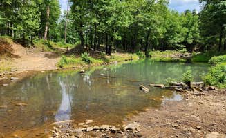
Hike to Brown Creek Cascade: A short 1/4-mile trail from the Brown Creek Cascade Dispersed Campsite leads to a scenic water feature. This hike includes a creek crossing, so prepare for wet feet. "The sound from the creek was soothing," notes one visitor who appreciated the natural soundtrack after a day of exploring.

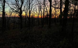
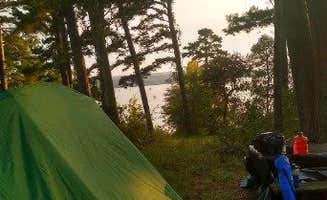
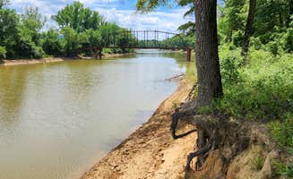
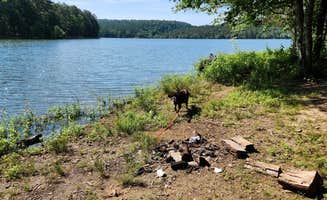
Stargazing at night: Minimal light pollution makes this area excellent for astronomy enthusiasts, though campers should select sites with open canopy views. "I really enjoyed this site. I stopped on a weekday and I was the only one there. It was nice watching the sun set over the lake," reports a camper at Harris Brake Lake.

Access the Ouachita National Recreation Trail: Several primitive camping spots provide direct access to this long-distance trail. Near the FR132-Grindstone Rd Dispersed site, "The Flatside Wilderness Area is across FR132 from this dispersed site; easy access to the Ouachita Trail," making it convenient for section hikers.

What campers like

Mountain panoramas: The elevated position of many sites offers long-range views. At Forest Service RD 132, campers enjoy "fantastic unobstructed view of the hills to the south" and "comfortable and well-maintained" sites with amenities like "a fire pit, prepared firewood, and a nice stump to chop more on."

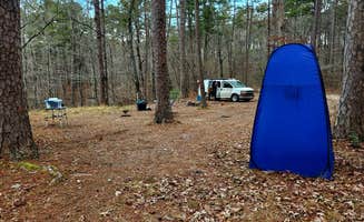
Privacy and solitude: Many sites see very little traffic, especially on weekdays. "We arrived late at night, and I'm glad we had our lightbar. It's dispersed camping, so no dumpster, no gray water dump. It does have a picnick table, though," explains a visitor to Harris Brake Lake.

Cost-free camping: All primitive camping in this area is free, allowing extended stays without permits. At Harris Brake Lake, "No amenities but it's quiet and pretty and free. The sunset was gorgeous. A little bit of a drive off of I40 but it's a fantastic spot."

What you should know

Weather preparedness: The region experiences rapid weather changes, particularly in spring and fall. During summer at Harris Brake Lake, one camper noted "absolutely beautiful place the fireflies here are amazing! Nobody else was camping here which made for some quiet nights. The locals fish and swim in the lake so light traffic."

Wildlife encounters: Ticks are prevalent during warm months. "There is a lot of ticks here I pulled 7 off of me and my dog in one night," reports a camper at Harris Brake Lake. Coyotes and foxes are also common, with some campers reporting "two gray foxes screeching ALL NIGHT LONG."

Cell service variability: Signal strength varies dramatically by location and carrier. At FR94 Dispersed Campsite, a camper reports "AT&T LTE service. Sporadic T-Mobile service," while other locations have no service at all.

Tips for camping with families

Prepare for trash concerns: Unfortunately, some sites suffer from litter problems. "This site is a wonderful place to camp because it is free. There was a ton of trash, including broken bottles and broken pans, near each site which was very unpleasant to see and camp near," notes a Harris Brake Lake visitor.

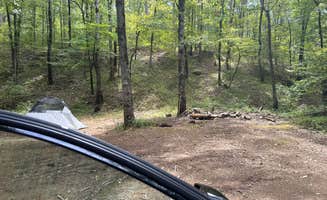
Scout for level tent spots: Many sites feature rocky ground challenging for tent sleeping. "If you are sleeping on the ground bring plenty of padding it is rocky and not very flat. If you are in a rooftop there are plenty of rocks to level up on," advises a Forest Service RD 132 camper.

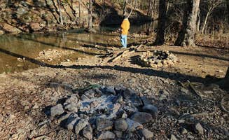
Consider proximity to water: Sites near creeks or lakes offer natural entertainment for children. At Brown Creek Rd/FR805 Dispersed camping area, "A small creek is down the hill behind the site; the creek is dry during the dry season. A beautiful wall of trees is across the creek."

Tips from RVers

Road condition awareness: Forest roads deteriorate significantly after rains. For Forest Service RD 153, a visitor warns "We couldn't even get to the campsite in our AWD Subaru Outback. There are drainage pipes exposed on the road."

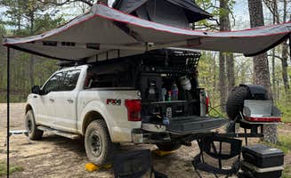
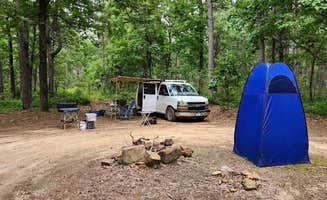
Smaller rigs recommended: Most sites accommodate compact setups better than large trailers. "We have a 25' travel trailer and didn't need to do any backing up to get in or out. Full cell signal with XFINITY mobile. 2 picnic tables and spots for fire overlooking lake. Ample places to park," reports a Harris Brake Lake camper.

Leveling challenges: Many sites require significant leveling due to uneven terrain. A Forest Service RD 132 reviewer states, "Not level; some leveling is required. Dirt surface with exposed embedded rock - may be uncomfortable for tent camping."

Frequently Asked Questions

Which is the most popular dispersed campsite near Casa, AR?

According to TheDyrt.com, the most popular dispersed campground near Casa, AR is Harris Brake Lake with a 4.1-star rating from 14 reviews.

What is the best site to find dispersed camping near Casa, AR?

TheDyrt.com has all 50 dispersed camping locations near Casa, AR, with real photos and reviews from campers.