Best Dispersed Camping near Mount Ida, AR

Dispersed camping areas exist throughout the Ouachita National Forest surrounding Mount Ida, Arkansas. The U.S. Forest Service manages several primitive camping zones in this region, including sites along Blue Knob Road, Turner Creek Road, Buck Knob, and North Fork Creek Road. These areas typically feature undesignated sites with minimal development, allowing campers to set up in clearings or pull-offs along forest roads. Most dispersed sites are located within the broader Ouachita National Forest system, which extends across much of western Arkansas.

Access to many dispersed sites requires travel on unpaved forest roads that vary significantly in condition. Several roads may require slow navigation due to erosion, particularly after rainfall. As one camper noted, "Forest roads reaching this part of the national forest were in good shape at the time of this review." High-clearance vehicles are recommended for reaching more remote areas, though many sites remain accessible to standard passenger vehicles when driven carefully. Most dispersed camping areas lack amenities such as drinking water, toilets, or trash service. Fire rings are common at established pull-offs, but campers should check current fire restrictions before visiting.

The Ouachita National Forest provides a range of camping environments from creekside locations to mountain views. Many sites offer proximity to hiking trails, including the Ouachita National Recreation Trail. A reviewer described one location as having "a beautiful view of the lake. Large enough for two rigs - truck camper size and smaller." Cell service varies significantly throughout the region, with many areas having limited or no connectivity. Wildlife sightings are common, and the dense forest provides natural privacy between most camping areas. Seasonal considerations include hunting activity in fall and potential road closures during winter weather. The relative seclusion of these areas makes them popular with campers seeking quiet natural settings away from developed campgrounds.

Best Dispersed Sites Near Mount Ida, Arkansas (40)

Show More
Showing results 1-10 of 40 campgrounds

2025 Detourist Giveaway

Presented byToyota Trucks

Review Campgrounds. Win Prizes.

Enter to Win


Dispersed Camping Reviews near Mount Ida, AR

37 Reviews of 40 Mount Ida Campgrounds


  • Fred S.The Dyrt PRO User
    Feb. 12, 2022

    Dispersed FR132 Ouachita National Forest, AR

    Dispersed Camping near Ouachita National Recreation Trail, AR

    Located along Forest Road 132 (Winona Scenic Drive) in the Ouachita National Forest, Saline County, Arkansas. Flatside Wilderness Area located across the road from the site. Access to the Ouachita National Recreation Trail located nearby. Free dispersed site, no facilities. Rock fire ring. Should be enough parking for 2 vehicles. Suitable for tent camping, car camping, truck camping & van camping. Mostly level. There was plenty of firewood left by the fire ring. Camped here in February; very quiet. Only 2 vehicles drove by. Had a few bars of T-Mobile service.

  • Fred S.The Dyrt PRO User
    Jan. 14, 2022

    Brown Creek Cascade Dispersed Campsite

    Free dispersed camping in the Ouachita National Forest

    Popular dispersed campsite in the Ouachita National Forest. Only one site; not a campground. Located on the gravel Brown Creek Road in Perry County, Arkansas. The South Fork of Brown Creek runs behind this campsite. Located next to the trailhead for Brown Creek Cascade - a short 1/4 mile hike (includes a creek crossing). This campsite is suitable for tent camping, car camping, camper vans & truck campers. Two vehicles can easily fit on this level site. There are other dispersed sites along Brown Creek Road. The site is close to the road; there's a large mud puddle covering one of the 2 entrances to this site. 2-wheel drive passenger cars can make it to the site. Large pine trees on the site. Hammock camping is possible. No water (except for creek). No toilets nor showers. No trash - take out what you bring in. May need to hike a ways in the woods to find firewood. Large rock fire ring on site. No AT&T and T-Mobile cell service. Very quiet; no vehicles passed by during the night. The sound from the creek was soothing.

  • Fred S.The Dyrt PRO User
    Apr. 23, 2025

    Brown Creek Rd/FR805 Dispersed

    Nice wooded dispersed site above a small creek

    Coordinates: 34.87057,-92.89844. Camped here on April 20, 2025. Located along Brown Creek Road (Forest Road 805), appoximately 1/2 mile west of the Brown Creek Cascade dispersed site and trail head (see separate listing). Large, level site with a dirt surface. Should easily accomadate 2 or 3 rigs and tents. Recommend campervan and smaller rigs. Due to the trees on the site, a truck camper will have a difficult time pulling all the way into the site (although it can park on the access driveway). Easy access from the forest road. The site is clearly visable from the forest road; no privacy, and dust may be an issue during the dry season. Only 6 vehicles passed by during my stay (which was on a Monday evening). There is a large, nicely constructed rock fire ring on the site; other than this, there are no amenities at the site. A small creek is down the hill behind the site; the creek is dry during the dry season. A beautiful wall of trees is across the creek. The site is shaded; solar charging and Starlink connectivity may be difficult. Hammock camping is possible. No T-Mobile cell service. No access to hiking trails at the site; trailheads for Brown Creek Cascade and the Ouachita National Recreation Trail are a short drive away. Loved this site. Peaceful at night. The only sounds came from the birds, the breeze and the creek. Note that due to recent severe Spring storms, portions of Brown Creek Road have some erosion. The rocky surface is moderately rough in places, although a 2WD passenger car can make it if driven carefully through the rough spots. No issues for high clearance 4x4 vehicles.

  • Fred S.The Dyrt PRO User
    May. 18, 2024

    Ouachitas FR179 Dispersed Site

    Creekside dispersed camping in the Ouachita National Forest

    Camped here on Dec 13, 2023. Along well maintained gravel forest road, FR 179 in the Ouachita National Forest, Saline County, Arkansas. Really nice large site with a creek that flows into the North Fork of the Saline River was behind the site. Site appears to be large enough for 2 rigs no large than a truck camper. Multiple tents can be set up here. Did not have a problem parking our camper van on a level spot. The dirt surface is level. The site has a rock fire ring. Only a few vehicles drove by the site on FR179. Lots of trees surrounding the site with an open sky above for star gazing. Fishing is possible in the North Fork of the Saline River a short walk south of the site. No hiking trails nearby. No T-Mobile or AT&T cell service.  Love this spot!

  • Jeff P.The Dyrt PRO User
    Dec. 9, 2020

    Ouachita National Forest Fourche Mountain

    Exploring the hidden road

    This section of the National Forest offers two hours gravel road through the forest. Please do your homework because the road signs are lacking. Word of advice, best to stay away during hunting season as we spotted over ten deer hunters in the area in a single day; a hunting paradise as well. On the path offers hidden creek waterfalls, lots of one way bridge and a serenity drive.

  • Fred S.The Dyrt PRO User
    Jun. 21, 2024

    FR132 Grindstone Mountain Area Dispersed, Ouachita NF. AR

    Forested Group Dispersed Site near Crystal Mountain Overlook

    Coordinates: 34.83903, -92.94556.  Set back from Forest Road 132 off of an old track - a short distance west of Forest Road 75. There is some minor erosion on the access to this site from FR132. Large site; good for groups. Should accommodate 4 rigs -  truck campersize & smaller. This site can accommodate 4x4 drivers that are planning to tackle Forest Road 132A to the Crystal Mountain Overlook - a short distance east of this site. FR132A is hikeable for those who do not drive high clearance 4x4s. The dispersed site has a level dirt surface. There are two rock fire rings. Beautiful forest backdrop. No T-Mobile service.

  • Fred S.The Dyrt PRO User
    Jun. 15, 2024

    CR133/FR146 Hogan Creek Dispersed, Ouachita NF, AR

    Small Dispersed Site, Tucked Away

    Coordinates: 34.93095,-93.32258. This a small dispersed camp site tucked away a short way from County Road 133/ Forest Rd 146 in the Ouachita National Forest. It's at the end of a short dirt track which may have been an old forest road. Above Hogan Creek, sounds of the creek can be head at this site. There is a path along the creek behind the campsite; it eventually provides access down hill to the creek. This is a secluded spot which can not be easily seen from CR133/FR146. Backing your vehicle into the site is best. There is a small rock fire ring at the end of the access track. The site's entrance is on the right hand side just after the bridge crossing Hogan Creek when coming from the west on CR133/FR146. A truck camper and smaller can fit into the site. A little bit of leveling may be required. Tent camping is also possible. It's a pretty campsite. The forest road is in great shape.

  • Fred S.The Dyrt PRO User
    Jan. 9, 2025

    Forest Rd 179 Creekside Dispersed

    Large creekside dispersed site

    Coordinates: 34.82029,-92.82184. Large creekside dispersed campsite located on a rocky, bumpy track, about 150 yards east of Forest Road 179 (aka Wildcat Mountain Rd). If going southbound on FR179, the track is on the left immediately after crossing a bridge. The track may look sketchy to some drivers, but I drove down it okay in my Subara. Good spot for car camping. The site itself is very rocky, so it may be uncomfortable for tent camping. There are trees for hammock camping. There are 3 large rock fire rings. This site is prone to flooding. The site appears to be popular and well used. There are no hiking trails, but the access track passes the site and continues along the creek - good for an easy stroll. Tried fishing here, but no luck. I do know from previous experience that there is fish in the creek. The creek is nice for a summertime dip when its running high. The site is mostly shaded; may be difficult to get a Starlink connection. I received no cell service. This is a pretty nice site, offering some privacy from the forest road and a wonderful sound of the creek.

  • Fred S.The Dyrt PRO User
    Jun. 21, 2024

    Crystal Mountain Dispersed

    Good View with Difficult Access

    I haven't camped here recently. Forest Road 132A, which climbs up to the Crystal Mountain Overlook fom Forest Road 132, is not maintained and badly eroded. Drivers with high clearance 4x4 vehicles and OHVs will enjoy driving up this track, but I don't recommend this drive for the average passenger vehicle. I no longer attempt this with my stock AWD Subaru Outback - just not enough clearance. There are two rock fire rings at the top. Despite the nice views at the top, the dispersed campsites are usually trashy. I included an older photo of the view with Lake Winona in the distance.


Guide to Mount Ida

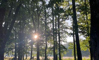
Dispersed camping locations around Mount Ida, Arkansas provide access to the Ouachita National Forest's rugged 1.8 million acres. The region sits in the valley between the Ouachita Mountains with elevations ranging from 600-2,700 feet. Seasonal considerations include high humidity during summer months when temperatures regularly exceed 90°F and potential creek flooding during spring rains.

What to do

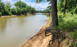
**Creek exploration: North Fork Creek Road offers riverside camping opportunities. "The site is near the North Fork Ouachita River, which can be reached by bushwacking down a steep hill and over rocks," notes Fred S. about North Fork Creek Rd Dispersed.

**Trail hiking: Access points to the Ouachita National Recreation Trail can be found near several primitive camping areas. Fred S. mentions, "Access to the Ouachite National Recreation Trail is a 4-mile drive on forest roads to the south (coordinates 34.73300,-93.21913)."

**Horseback riding: The Bear Creek Horse Camp provides equestrian-focused primitive camping. According to a review, "The camp serves as a small primitive camping area for equestrian riders on the network of interconnecting loop trails that comprise the Bear Creek Equestrain Trail system. These trails are also open to hikers."
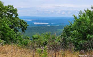
What campers like

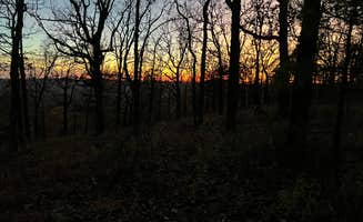
**Ridge views: Some dispersed sites offer elevated perspectives. Logan R. shares about Forest Service RD 153: "This campsite has amazing 360 sunsets and sunrises. A bit rocky for tent campers but should have no trouble finding a spot for a 4 man tent."

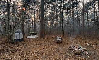
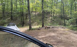
**Solitude: Many campers appreciate the remote setting. "Very secluded spot no amenities just a rock fire ring. Very peaceful," reports Jacob about Turner Creek Road.

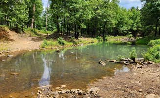
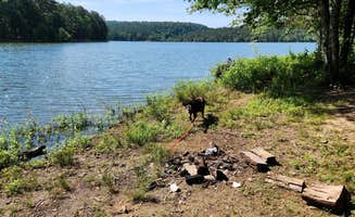
**Swimming holes: Summer heat makes water access valuable. Matthew J. notes about Irons Fork: "I went in mid July so it was hot and humid but I was able to swim a bit to help that. Some nice mature trees were there but didn't get in the way of our view of the lake."

What you should know

**Road conditions: Forest service roads require planning. "Forest road 153 between this site and Highway 7 appears to have been badly damaged by heavy rain and erosion. Looks like attempts were made to repair it, but still sketchy in places," warns Fred S. Another camper notes, "We couldn't even get to the campsite in our AWD Subaru Outback. There are drainage pipes exposed on the road."

**Site accessibility: Some locations have tight entrances. Carlos P. mentions about Blue Knob Road: "I have a CDL and back stuff all day. Don't try to pull in. Back in off the Buck Mountain."

**Wildlife awareness: Take proper precautions in bear country. "It is black bear country, so just be smart about your waste and food storage," advises Matthew J., while another camper reported, "others trash was gone through by wildlife in the bathroom."

Tips for camping with families

**Site selection: Look for locations with natural features kids can explore. "The site was clean and had a large rock fire ring. The site is near the North Fork Ouachita River," notes a camper about North Fork Creek Rd.

**Safety considerations: Be mindful of potential hazards. "Poison ivy is present," warns Fred S. about certain sites in the area.

**Seasonal planning: Hunting seasons can impact camping safety. Jeff P. warns about Fourche Mountain: "Word of advice, best to stay away during hunting season as we spotted over ten deer hunters in the area in a single day."

Tips from RVers

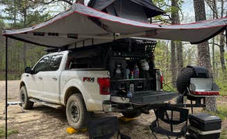
**Size limitations: Most primitive sites accommodate smaller rigs. Heather C. shares about Blue Knob Road: "I have a 30ft Class C which is probably the largest vehicle you would want to drive down the dirt road to this site."

**Leveling requirements: Prepare for uneven terrain. One RVer notes: "Note, site is a little uneven, so chocks were helpful."

**Site capacity: Groups should research multi-rig options. Fred S. describes one location: "Large, open dispersed site along Gladstone Forest Rd (FR11) in the Ouachita National Forest. Should accomodate 4 rigs - truck camper size and smaller."

Frequently Asked Questions

Which is the most popular dispersed campsite near Mount Ida, AR?

According to TheDyrt.com, the most popular dispersed campground near Mount Ida, AR is Irons Fork with a 3.7-star rating from 3 reviews.

What is the best site to find dispersed camping near Mount Ida, AR?

TheDyrt.com has all 40 dispersed camping locations near Mount Ida, AR, with real photos and reviews from campers.