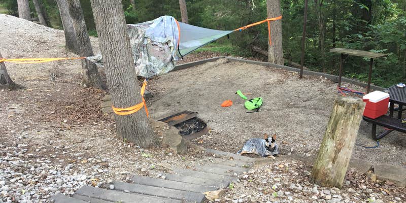
Army Corps of Engineers campsites line terraced gravel pads along Nolin River Lake, with most sites angled to provide lake views despite close spacing. The campground operates seasonally from early May through mid-October, accommodating RVs up to 100 feet with full hookups and offering tent camping on designated pads.
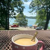
Sites cluster in multiple loops at different elevations, creating a tiered layout where campers can see neighbors but also catch glimpses of the water through the trees. "The sites are strategically stacked in each loop. Close but angled so you see a lot of your neighbors but a lot of scenery too," explains Shelly S.. Lakefront sites like D6 and A49 fill quickly, with some campers noting competition for prime spots. The rocky shoreline allows direct water access for launching kayaks and fishing from the bank.
Fishing dominates the lake activity, with anglers working from boats, kayaks, and shore positions throughout the day. The lake accommodates powerboats alongside paddle craft, and a boat ramp provides launching access. A two-mile trail called Shady Creek winds through the campground, though recent visitors report heavy spider webs across the path and minimal maintenance. The trail passes through wooded areas and crosses small streams before reaching rock formations.
Three bathhouses serve the campground with free showers, though water temperature can fluctuate between cold and scalding. Cell service works well for Verizon and AT&T users, while WiFi availability varies by location. The campground enforces quiet hours from 10 PM to 6 AM, though experiences with noise levels differ among visitors. Nolin Lake State Park Campground sits less than two miles away for additional options.
Reservations are recommended for weekend visits, especially for waterfront sites during peak summer months.
Description
Overview
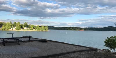
Moutardier Campground sits on the shores of Nolin River Lake in the rolling landscape of southern Kentucky. The large lake and surrounding greenery create a recreational oasis for outdoor enthusiasts. Click here to take a tour of our lake.
Recreation
Known for its unique blue/green water, Nolin Lake is one of the top lakes in Kentucky for catfish, bass, crappie and walleye fishing. Visitors can enjoy scenic canoe and boat trips along the river, part of which is located within Mammoth Cave National Park. Boat ramps are provided around the lake for campers' convenience. The Moutardier, Ponderosa and Wax Marinas are located around the lake and offer pontoon and john boat rentals, as well as boat slips and groceries, bait, gas and more. Several hiking trails also wind along the shoreline and into the surrounding forest. Shady Creek Trail, located within the recreation area, is known for its array of wildflowers and greenery.
Facilities
Moutardier Campground offers 167 campsites, complete with modern amenities like electric and water hookups. We have flush toilets and shower houses. Campsites are located along the shoreline allowing easy access to the lake for visitors.
Natural Features
Nolin Dam creates a 5,795-acre lake that draws more than two million visitors each year to enjoy water sports and camping in the surrounding expanse of rolling forest.
Contact Info
This location is unstaffed. To speak with our main office for general information, please call: (270) 286-4511.
Nearby Attractions
Mammoth Cave National Park is located a short drive or ferry ride away from the campground, and several golf courses and riding stables are located around the lake.
Charges & Cancellations
* Once your reservation has been created, there will be a $10.00 fee to cancel and a $10.00 fee to change your sites or dates. * Cancellations made the day before, or up to the day after your arrival date will also be charged the first nights use fee. * No-Shows are charged a $20.00 fee plus the first nights use fee. * If your reservation is for 1 night, and you have been charged the first nights use fee, there is no $10.00 service fee.
Fee Info
No refunds for recreation use fees may be made at the project.
Warning 1 Alert is In Effect
There is 1 alert for this campground. Camp safely!
Warning 1 Alert is In Effect
There is 1 alert for this campground. Camp safely!
Recent weather has affected both Dog Creek and Moutardier Campground Reservations. Flooding will affect specific sites and notifications have been sent to those sites with reservations affected. There are still sites open that have not been affected, please check Recreation.gov if you are making alternate plans. Conditions will continue to be monitored. Contact the Nolin River Lake office at 270-286-4511 if you have questions.
Map & DirectionsMoutardier is located in Kentucky near Sweeden
Directions
From Bowling Green, KY Follow US 31W North from Bowling Green for approximately 14 miles then turn left onto KY 101. In appriximately 6 miles, Hwy 101 becomes Hwy 259 North. Follow Hwy259 North for 16 miles before turning right on KY 2067. Drive approximately 2 miles and you'll see signs for the Moutardier Campground on the right. Total driving distance from Bowling Green is about 37 miles; driving time is around 55 minutes. From Louisville, KY Take I-65 south from Louisville for approximately 45 miles. Take exit 91, Follow WK Pkwy for 29 miles to exit 107(Hwy 259) Follow 259 South for 12 miles. Turn left on KY 2067. Drive approximately 2 miles and you'll see signs for the Moutardier Campground on the right. Total dricing distance from Louisville is about 88 miles; driving time is around 1 hour and 40 minutes. From Nashville, TN Take I65 North for approximately 66 miles. Merge onto KY 446 via exit 28 (towards Hwy 31W) Follow 31W North for approximately 10 miles, then turn left on KY 101. In appriximately 6 miles, Hwy 101 becomes Hwy 259 North. Follow Hwy259 North for 16 miles before turning right on KY 2067. Drive approximately 2 miles and you'll see signs for the Moutardier Campground on the right. Total driving distance from Nashville is about 100 miles; driving time is around 1 hour, 45 minutes.
Address
1343 Moutardier Road
Leitchfield, KY 42754
Coordinates
37.3163889 N
86.2330556 W
Connectivity
 T-Mobile5GExcellent Coverage
 VerizonLTESome CoverageVerified by 2 usersLast on 7/1/26
- AT&TLTESome Coverage
Connectivity
- T-Mobile5GExcellent Coverage
- VerizonLTESome CoverageVerified by 2 usersLast on 7/1/26
- AT&TLTESome Coverage
Access
- Drive-InPark next to your site
- Walk-InPark in a lot, walk to your site.
- Boat-InSites accessible by watercraft.
Site Types
- Tent Sites
- RV Sites
- Standard (Tent/RV)
- Group
- Cabins
Features
For Campers
- Trash
- Picnic Table
- Firewood Available
- Phone Service
- Reservable
- WiFi
- Drinking Water
- Electric Hookups
- Toilets
- Alcohol
- Pets
- Fires
For Vehicles
- Sanitary Dump
- Sewer Hookups
- Water Hookups
- Pull-Through Sites
- 50 Amp Hookups
- Big Rig Friendly
Contact
General Info
Reservations
Drive Time
- 38 min from Bowling Green, KY
- 39 min from Elizabethtown, KY
- 1 hr 6 min from Owensboro, KY
- 1 hr 14 min from Louisville, KY