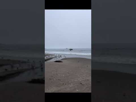
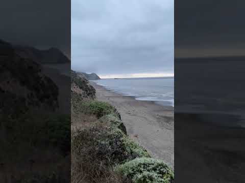
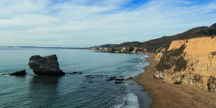
Ranger Review: Mountain House’sHomestyle Turkey Casserole Dinner at Wildcat Campground – Point Reyes National Seashore: Great spot to watch the fog role in and explore some solitude on the beach…
Campsite Review: Wildcat Campground, in Point Reyes National Seashore, is located in an open meadow on a bluff overlooking the ocean with a short walk to the beach and a 3.2 kilometer (2.0 miles) round-trip walk to Alamere Falls, which is one of the main draws of this campground. The Falls will get extremely busy during the day as people start hiking in and this way you can head over for a little bit without too any people first thing in the morning. Tip: If you head in the opposite direction of the Falls, you’ll have miles and miles of no one around…
The campground is about 10 kilometer (6.3 miles) hike from the Bear Valley Visitor Center or an 8.8 kilometer (5.5 miles) hike on the Coast Trail from Palomarin.
Note: Reservation/Confirmation Notice ≠ Permit. So even though you may have already made a reservation online, you must stop by the Bear Valley Visitor Center on your arrival date to pick up your camping permit and parking pass.
So, if you want to drive back to the Palomarin trailhead for the “shorter” hike this could make your overall trip a bit longer as it can be almost a 40-minute drive. Also, you could bike to the campground, but the only bicycling route is via a strenuous 10.7 kilometer (6.7 miles) ride along the Stewart Trail from the Five Brooks Trailhead. The campground consists of five individual sites and three group sites; three of the individual sites only hold up to four people.
Vaulted toilets, and potable water! Campsites have charcoal grills, picnic tables, bear boxes/food storage lockers, and some sites have a little privacy due to the high grass. Because the campground is in the middle of a grass field, campfires are only allowed on the beach (You need to get a permit from the Visitor Center). That’s really a good thing as whom wants to wake up in the middle of a field on fire. Also, you might want to be on the lookout for small vermin running around the fields and looking to snag any food you’ve left out. We didn’t have any issues, but definitely heard them.
During our hike in and out we hung out at site #2 as this site didn't have people currently camping there. I'd be cautious about actually staying at this site as unfortunately it had the horse riders come right by as this is really the only way they can get to the hitches…I’d avoid this site at all costs if possible (unless you come in on a horse!). Also, it looked like sites #4 and #8 are basically connected and if you happen to be there in both sites with friends that might be OK, otherwise you’re staring at strangers the entire time…
Thus, from our exploring the campground I’d recommend campsites 6 &/or 7 as they provide a little more seclusion. Also, as I went in late July the majority of the campground seemed a little drab. Mostly brown dried out and dead glass, from what I understand this is typical of summer in this part of CA. I’d maybe try coming in spring (May) as the wildflowers in the area are amazing!! Saw them off the Tomales Point Trail, which I highly recommend.
While the campgrounds themselves are nice, and I appreciate not having to lug in all of our water and the use of the vault toilets I personally think that the amount of day hikers, and horse back riders detracts from the feel of this being a back-country campground. Maybe in the Fall/Winter or Spring it’s better.
Gear/Product Review: As a Ranger for TheDyrt.com from time to time I get to review different products and during this trip I got to reward myself for the hike into the campground with Mountain House’s new 2-Serving Homestyle Turkey Dinner Casserole. I’ll admit that after reading the description I was a little skeptical at first, however, I think the best way of describing this meal is that it tastes like Thanksgiving!!
I really enjoyed the combination of turkey, stuffing, vegetable and spices. They really did add up to what I think a true Thanksgiving day meal tastes like. While like any dehydrated meal you have to be good at mixing it, this one is no exception. If you don’t mix it up properly (they suggest at least twice in the directions) you could definitely find yourself with a ball of spice or a piece of stuffing that isn’t fully rehydrated, but that’s easily fixed by mixing it up some more.
The large chucks of turkey and what ends up looking like real stuffing was a very pleasant surprise to this meal. It was well deserved after an 8+ mile hike. The amount of carbs and protein are perfect for that post hike meal. Especially if you eat both servings like I did! Although, I think that a normal couple could easily share the meal.
As my final thought, I would definitely recommend that anyone looking for a meal that tastes home cooked with little effort, you take this one along with you on your next backpacking trip. As it weights less than 4 oz, you’ll be able to bring quite a few!
I give the Mountain HouseHomestyle Turkey Dinner Casserole 4.75/5 Stars!


 T-MobileNo Coverage