Best Dispersed Camping near Bishop, CA

The Eastern Sierra mountains frame Bishop's dispersed camping options, with some of the best sites found on BLM and national forest land. Bishop City Park Campground has nearby undeveloped areas where you can camp without designated sites or facilities. You'll need to bring everything with you since these spots lack restrooms and water sources. Following Leave No Trace practices helps keep these places wild for future campers. Several primitive spots exist around Bishop Area State Park, but remember to pack out all trash and waste. Camping regulations require staying at least 200 feet from streams and lakes to protect water quality. Most dispersed areas allow stays up to 14 days before you need to move. Many access roads become rutted after rain, making high-clearance vehicles necessary in places like Buttermilk Country. The backcountry feeling is worth it though, with few neighbors and dark night skies. Fire bans happen frequently during dry months, so bring a camp stove instead. About 20 minutes west of town, the Bishop Recreation Area has good flat spots for camping. Winter snow blocks many forest roads from November through May, while July and August can bring 100+ degree heat. Check with the White Mountain Ranger District for current road and trail conditions before heading out. The drive to get groceries and gas in Bishop is typically 15-30 minutes from most camping areas.

Best Dispersed Sites Near Bishop, California (54)

    1. Volcanic Tableland BLM Dispersed Camping

    13 Reviews
    Bishop, CA
    4 miles
    Website
    +1 (760) 872-5000

    "This BLM land is managed by the Bishop Field Office.  

    There are many clearings where you can find a spot to camp."

    "Easy drive to Bishop for supplies, and the free dump & water fill at the Speedway at the other end of town is really nice. 

    The road in is fairly washboarded, but manageable."

    2. McGee Creek

    6 Reviews
    Bishop, CA
    7 miles

    "May 2023- We happened upon this place through "the dyrt" and what a hidden jewel! We camped right next to the stream and stayed one night and it was peaceful and far away from any highway."

    "Such a great spot and close to a lot of the local hiking. Nice and flat areas for van parking. Some occasional noise from the road but not bothersome at all."

    3. Deep Canyon

    2 Reviews
    Bishop, CA
    6 miles
    Website

    "This is a must stop on the way to mammoth lakes. big, open, former river bed i assume. Probably not safe during rainy seasons."

    "The area was dry when I was there. Nice views."

    4. Poleta OHV Upper Staging Area

    1 Review
    Bishop, CA
    6 miles
    Website

    "This is a great location, I was here mid week and there’s hardly anybody here, I imagine on the weekend it probably gets more crowded and is an ATV/off-road area that’s probably a little more loud on"

    5. White Mountains Despersed

    1 Review
    Dyer, CA
    13 miles

    "This should be the trailhead for white mountain . There is a bathroom but that’s it . Be prepared to drive on dirt roads to get here"

    7. Crab Cooker Hotsprings - Dispersed Camping

    11 Reviews
    Inyo National Forest, CA
    30 miles
    Website

    "4x4 or high clearance coming in. Long dirt road with dips and rocks. Water only flowing in winter months. Lots of tent camping spots along with 8 back in spots. Really amazing views 360 degrees."

    "About 8 spots at the end of the dirt road. Only one bar of service. It would be hard to access with anything thing over 22ft."

    9. Piute Creek Dispersed

    1 Review
    Mono Hot Springs, CA
    21 miles
    Website

    "There are a few ways to exit (or enter) the John Muir Trail and for our trip we chose to exit on the Piute Pass Trail (also known as Piute Canyon closer to the JMT)."

Show More
Showing results 1-10 of 54 campgrounds

2025 Detourist Giveaway

Presented byToyota Trucks

Review Campgrounds. Win Prizes.

Enter to Win


Dispersed Camping Reviews near Bishop, CA

122 Reviews of 54 Bishop Campgrounds


  • Thomas K.The Dyrt PRO User
    Jul. 9, 2020

    Crab Cooker Hotsprings - Dispersed Camping

    Private hotspring with mountain views

    4x4 or high clearance coming in. Long dirt road with dips and rocks. Water only flowing in winter months. Lots of tent camping spots along with 8 back in spots. Really amazing views 360 degrees. No service with Verizon.

  • Laura M.The Dyrt PRO User
    Apr. 17, 2021

    Sage Hen Dispersed

    Beautiful, near Mono Lake

    The dirt road into this spot off of Hwy 120 is washboarded but doable. This spot is at an intersection of forest service road 1S158A and Sage Hen Rd. There was still snow on the dirt road at this time of year (in mid April) so be aware,  and there are also low hanging branches that might make it tough for taller rigs. 

    This spot is a large flat area with zero amenities so bring water and pack in and pack out. 

    Good for a night or two if you want to hike or bike along the plethora of forest service roads. There were signs on the way in for both free range cattle and horses, but we didn't see any.

     Cell service with Verizon, weak but usable.

  • Laura M.The Dyrt PRO User
    Apr. 9, 2021

    Mono Lake South Dispersed

    Beautiful view of Mono Lake

    All around Mono Lake is USFS and BLM land that is open for dispersed camping, as long as you stay above the 1941 water line (you will see signs marking this line, which is fairly close to the lake). Note there are multiple pull out areas and forest service roads to stay in along Hwy 120 east just be mindful that the entire area is sand, as some vehicles may get stuck.

    The road into these spots is quite sandy and narrow in some places, but we did fine in our 26' Class C. There is a very large previously burned area with charred remains of plants and trees but it made for some interesting eerie photos. Very quiet place with amazing views and stunning night sky. There are no amenities so bring water and pack in and pack out all trash. Nearby are various hikes and other roads to the range of craters in the area and the tufas along Mono Lake.

    We stayed there on a Monday night and did not see anybody else around, other than a truck that drove past our camp spot in the night.  Very quiet night.

    Good cell reception from AT&T, Verizon and T-Mobile.

    Note that Google Maps said that Hwy 120 is closed Oct through May and would not direct us to this area via that road, but the road was open in April 2021, probably due to the mild winter.  Check Hwy 120 conditions for yourself because without it you miss out on so much beautiful area to explore.

  • Dave V.
    Sep. 13, 2018

    Gladys Lake Backcountry, Ansel Adams Wilderness

    Breathtaking Beauty!

    RANGER REVIEW: Mountain House Spaghetti with Meat Sauce at Gladys Lake Backcountry Campsites, Ansel Adams Wilderness, CA

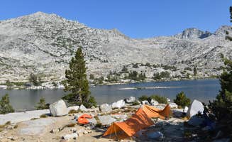
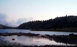
    CAMPGROUND REVIEW: Gladys Lake Backcountry Campsite, Ansel Adams Wilderness

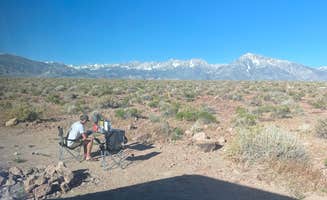
    Backcountry camping often offers great hiking, epic scenery, serene solitude and otherwise missed sights. Depending on location, backcountry campsite locations can offer their own challenges, whether through the permitting process, preparation of gear and meals, logistics, or difficult terrain…but the trade offs can pay out big dividends.

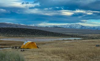
    Leaving behind the din of packed campgrounds…getting unplugged from electronic encumbrances…relaxing beside an untouched alpine lake where the only sound you hear is the whir of dragonfly wings as they dart about.

    Only a set number of backcountry permits are issued daily, so crowds and impact remain minimal to nonexistent.

    Permits are necessary for all backcountry overnight stays in the Inyo National Forest. https://www.fs.usda.gov/main/inyo/passes-permits

    Whenever backcountry hiking/camping in California, do yourself a service and go online https://www.fs.usda.gov/detail/inyo/passes-permits/?cid=stelprdb5139009 and take the California Campfire Permit test to acquire your certificate and possess it when in the backcountry.

    Several ways to get to Gladys Lake exist…

    1. John Muir Trail (JMT) thru-hike permits NOBO or SOBO

    2. John Muir Trail section hike permits

    3. Wilderness Permits Day hike permits

    You could enter from Reds Meadows and follow the JMT north to Gladys Lake…or better from Agnew Meadows and follow the Shadow Creek Trail (https://www.fs.usda.gov/recarea/inyo/recreation/hiking/recarea/?recid=21272&actid=51 ) up and around Shadow Lake and then south on the JMT past Rosalie Lake to Gladys Lake. Each access trail has a daily quota…such as Shadow Creek, which has a daily quota of 30…18 secured through reservation and 12 walk-ups. So if you are choosing to walk-up, have some flexibility of starting days.

    We had a JMT SOBO permit acquired six months in advance through the NPS permit lottery. But next visit, I will likely enter through Agnew Meadows via day permit.

    Most hikers will stop and camp at Rosalie Lake, which is a wonderful option and a much larger lake. Some would suggest a more picturesque lake than Gladys Lake…but that is all in the eye of the beholder.

    August of 2018 saw little precipitation and the winter snowfall was below expectations, so lake water levels were lower and surrounding shoreline not marshy or soggy. Which made for dry and mosquito free conditions.

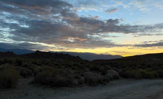
    The effects of local forest fires did cover surrounding mountain views during certain times of the day, and brought with it a bit of lung burning and eye stinging. Early morning and late evening hours brought clearer skies.

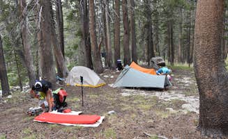
    Be forewarned that seemingly every backcountry campsite brings with it a steep uphill slog, but worth it. Gladys Lake is at 9600 ft elevation.

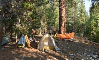
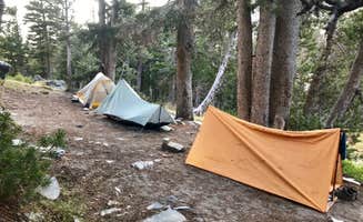
    I believe there was one other camper at Gladys Lake the night we stayed…but we neither heard nor saw them. It was a perfectly peaceful evening!

    Amenities? Well, no showers…no toilets…no water spigots…no electricity…no picnic tables…one lonely stone fire ring but open fires are not permitted. No cell service or WiFi…no general store or local grocery store. However, Gladys Lake water was refreshing both to wade and drink (filtered). You are surrounded by fragrant conifers that buffer sound. A perfectly peaceful location to relax and dream.

    PRODUCT REVIEW: Mountain House Spaghetti With Meat Sauce

    https://www.mountainhouse.com/

    As a frequent user of Mountain House freezes dried dinners, and being a creature of habit, I often settle into a couple favorite meals and don’t deviate to new offerings. Mundane and boring?…perhaps.

    But…after winning $100 worth of Mountain House meals through an early season TheDyrt.com contest… and with my daughter as my hiking buddy, I selected several different meals to avoid mutiny.

    One of these meal pouches was Mountain House’s Spaghetti with Meat Sauce.

    I admit, I was a little suspect as to how freeze-dried spaghetti with meat sauce would taste, but we were both very pleased with the sauce flavors, seasoning and the amount of meat in the sauce. The only thing I would add is a couple slices of toasted garlic bread.

    If the next rotation of Mountain House Spaghetti with Meat Sauce was easily located in our bear canisters, we would’ve likely had a second helping…but sadly, it was not.

    In pairing down weight before our backcountry hike, I removed the contents from Mountain House’s original packaging and utilized a commercial vacuum sealer to make smaller, lighter meal packs as 11 days of food needed to fit in a bear canister. It worked, but the distinct drawback was not being able to prepare the meal in the resealable pouch. A pot was necessary to allow the freeze-dried contents to soak in the boiling water. So clean up was more extensive than it would’ve been by using the Mountain House resealable pouch. It was a trade off and we made it work.

    If you are new to Mountain House freeze dried meals, directions are printed plain and simple on the pouch.

    •Measure out the prescribed amount of water

    •boil water

    •open meal pouch and remove moisture packet

    •pour boiling water in pouch and stir contents thoroughly

    •seal pouch for prescribed time

    •open pouch and stir contents

    •serve and enjoy

    It doesn’t get any easier.

  • Laura M.The Dyrt PRO User
    Apr. 3, 2021

    Independence BLM Dispersed

    Free dispersed camping outside of Independence, CA

    Independence is on Hwy 395 about an hour south of Bishop and about half an hour north of Alabama Hills.  Which is to say it's a great location with a lot of places to explore and hike.  

    This land is a good spot to stay for a few nights while exploring the area, or if you just need a free place to sleep.  The spot we marked here is about 2 miles west of Independence, but there are a few other cleared out areas that you can camp on, just check Google satellite maps.  We didn't see anyone else camping on the BLM land while we stayed here, but we saw a lot of people driving up and down Onion Valley Rd.

    The area is clean and very quiet, zero shade and zero amenities.  Please help keep it clean by packing out your trash.

    Some of the dirt roads might need a high clearance vehicle but on the spot I've marked we made it fine in our 26ft motorhome.

  • Laura M.The Dyrt PRO User
    Oct. 10, 2022

    Owens River Road Dispersed

    Lots of Spots Along Owens River Rd

    There are a ton of spots to camp along Owens River Rd.  All the spots closest to 395 were taken when we went in late September, but we found this spot that I've marked here that was easily accessible in our 26ft Motorhome.  Owens River Rd itself is paved, but the offshoots are hit or miss so take it slowly and proceed at your vehicle's ability. 

    This particular spot was nice and big and is probably suitable for any size rig.  The pavement on the road heading in was partly washed out but we were easily able to drive around the pits.  See video - it's long but I recorded us leaving the spot and showed the pits in the road.

    Good cell reception, very quiet, very little traffic.  

    No amenities, no toilets, no trash service.  Area was clean! Hopefully it stays that way.

  • Alex P.The Dyrt PRO User
    Aug. 13, 2020

    Inyo National Forest Dispersed Camping

    Beautiful dispersed camping

    You can get maps for this area at some of the information boards at the beginning of the dirt roads, they also have an app that will show you all the roads in the area. What’s nice is the map color codes the roads so that you know what your vehicle is capable of driving on. Some of the roads can get a bit rough, so make sure you know your vehicles limits. Once you get out there, enjoy! It’s so beautiful and quiet. Please make sure you pack in and pack out your trash, there are no services for that. Also, be aware of fire restrictions!

  • LThe Dyrt PRO User
    Aug. 29, 2023

    McGee Creek

    Beautiful and Remote yet doable in Class B Van

    May 2023- We happened upon this place through "the dyrt" and what a hidden jewel! We camped right next to the stream and stayed one night and it was peaceful and far away from any highway. The road becomes dirt and while bumpy in places, our class B van with low clearance did fine going slow. The creek was 40 feet from our spot, running well (Spring of 2023 after record snowfall) and the dog loved playing it it. We arrived 1pm and there was just one other vehicle. By evening there were about 7 more vehicles but they dispersed. We camped at the first turn off where you'll see the Forest Service Sign. You can continue further on the bumpy road and there are other sites along the way, which I can't speak about as we did not go there. BE CAREFUL as there are two camps with same name. The one we stayed at is just west of Bishop. There is another "Mc Gee Creek Forest Service Campground" west of Lake Crowley which looks great, but I've not been there.

  • Megan S.
    Jul. 28, 2022

    Scenic Loop - Dispersed Camping

    Great free camping!

    Got here on Sunday - plenty of spots to park the camper van both Sunday and Monday. Multiple turn offs on the Scenic Loop road to camp at. No bathrooms, water, electricity, or fire rings. Pretty dispersed but close enough to downtown. Would go back!


Guide to Bishop

Primitive camping near Bishop, California offers campers volcanic tablelands, creekside sites, and access to high desert terrain with elevations ranging from 4,000 to over 8,000 feet. The area receives less than 6 inches of rainfall annually, creating arid conditions that require careful water planning. Roads into many dispersed sites remain rutted year-round, particularly following winter precipitation.

What to do

Bouldering opportunities: The Volcanic Tableland area provides numerous rock climbing options. "Sad Boulders is a rock climber's playground. There are petroglyphs to be found on some of the boulders in the area, as well as rattle snakes, only saw one baby though," notes Laura M. from Volcanic Tableland BLM Dispersed Camping.

Hiking at McGee Creek: Access trails directly from your camping area without driving. "The real glory is in the McGee of Creek trail at the end of the road. It's only a couple of miles away and is fantastic, easy hiking. The October foliage was amazing," reports Beth M. from McGee Creek.

Hot springs soaking: Several primitive hot springs let you relax after exploring. "The hot spring was kind of broken when we were there so that was a bummer, but you could hike out to the slightly muddy creek for some hot water," explains Alyssa L., who visited Crab Cooker Hotsprings.

What campers like

Stargazing opportunities: The dark skies around Bishop attract astronomers and casual stargazers. "I drove in at night and the Milky Way was shining bright. Got some decent star shots. It's a great way point if you're traveling through and need a quiet and free place to crash," shares Jibran B. from Volcanic Tableland BLM Dispersed Camping.

Privacy between sites: Many dispersed camping areas offer significant distance between camps. "There are many clearings where you can find a spot to camp. Even though most spots were taken the weekend we stayed there, everyone is so spread out that you still have silence and privacy," writes Laura M. about her experience at Crab Cooker Hotsprings.

Mountain views: The surrounding ranges create dramatic backdrops for campsites. "Beautiful spot overlooking Bishop Valley framed by the Sierras and white mountains," notes Steve L. about his camping at Volcanic Tableland BLM Dispersed Camping.

What you should know

Cell service varies: Coverage depends on specific location and carrier. "There is ok Verizon service, better ATT service, and T-Mobile alternated between roaming and no service," reports Laura M. about Volcanic Tableland.

Fire restrictions change seasonally: Check current regulations before planning campfires. "Roads were open as of 5/23. A handful of spots with rock fire pits. Not too much noise and lots of stars," shares Andy V. about his May visit to Volcanic Tableland.

Road conditions require planning: Many access roads need high clearance vehicles. "The road in, Casa Diablo, is gravel and heavily washboarded," warns Laura M. about Deep Canyon. Another camper notes that Deep Canyon has "Some soft gravel/sand areas, but made it everywhere fine with fwd. The area was dry when I was there."

Tips for camping with families

Watch for hazardous plants: Some areas have thorny vegetation that can harm pets and children. "Something we hadn't noticed before were all the goatheads, everywhere. Watch your dog's paws," cautions Laura M. about Volcanic Tableland.

Creek access spots: For family-friendly water play, seek out creek-adjacent sites. "Such a great spot and close to a lot of the local hiking. Nice and flat areas for van parking. Some occasional noise from the road but not bothersome at all. Spots closer to the creek create a nice white noise," shares Samantha D. about McGee Creek.

Animal encounters: Cattle and wildlife sightings add to the experience. "Views on the other are rolling fields/foothills with lots of cutie vocal Moo Moos and Alkali Lake! You can see other hot springs in the distance," describes Rachel W. from Poleta OHV Upper Staging Area.

Tips from RVers

Length restrictions: Many areas have limited turning radius or narrow access roads. "It would be hard to access with anything thing over 22ft," explains Thomas K. about Crab Cooker Hotsprings.

Suitable parking surfaces: Look for firm ground, especially after rain. "This is a great location, I was here mid week and there's hardly anybody here, I imagine on the weekend it probably gets more crowded and is an ATV/off-road area that's probably a little more loud on weekends as well," reports dirtdog about Poleta OHV Upper Staging Area.

Dump station access: Plan for waste management needs. "Easy drive to Bishop for supplies, and the free dump & water fill at the Speedway at the other end of town is really nice," notes Laura M. about facilities near Volcanic Tableland.

Frequently Asked Questions

Is there free BLM camping available near Bishop, California?

Yes, numerous free BLM camping options exist near Bishop. Volcanic Tableland BLM Dispersed Camping offers multiple clearings for camping managed by the Bishop Field Office. Independence BLM Dispersed provides free camping about an hour south of Bishop with easy highway access, making it ideal for exploring the Eastern Sierra region. Additional BLM areas include Poleta OHV Upper Staging Area and areas around White Mountains. These sites typically allow 14-day maximum stays and follow leave-no-trace principles. Most have no facilities (no water, toilets, or designated fire rings), so come prepared with everything you need, including sufficient water. Many BLM sites have variable road conditions, so check access requirements for your specific vehicle.

What are the regulations for dispersed camping in Bishop, CA?

Dispersed camping near Bishop follows standard public land regulations. Most areas have a 14-day maximum stay limit, as noted at Laurel Springs Campground. Fire restrictions commonly apply during summer months, so portable stoves are recommended. The pack-in, pack-out principle is strictly enforced—all trash must be removed when you leave. At Mono Lake South Dispersed, camping is permitted on USFS and BLM land but requires staying above the 1941 water line (marked by signs). Many areas require camping in previously disturbed sites only, staying at least 200 feet from water sources. Some locations may be seasonally closed due to wildlife protection or weather conditions. Always check current regulations with the Bishop Field Office of BLM or Inyo National Forest before your trip.

Where can I find dispersed camping near Bishop, CA?

Bishop offers numerous dispersed camping options in the surrounding area. Owens River Road Dispersed provides many camping spots along a paved main road with various offshoots suitable for RVs up to 26ft, though road conditions on side routes vary. Scenic Loop - Dispersed Camping offers multiple turnoffs for camping, with no facilities but convenient proximity to downtown Bishop. Other options include Buttermilk Country Road, Deep Canyon, and Silver Canyon Road. Most sites require careful navigation on dirt roads—some with washboarding or rocky sections—so check vehicle clearance requirements before venturing out. Many sites fill quickly on weekends, especially those closest to Highway 395, so arrive early or have backup locations in mind.