Best Dispersed Camping near Pencil Bluff, AR

Ouachita National Forest provides numerous dispersed camping options near Pencil Bluff, Arkansas, with sites concentrated along forest service roads. Blue Knob Road offers secluded spots where larger vehicles require careful navigation. "I have a 30ft Class C which is probably the largest vehicle you would want to drive down the dirt road to this site," notes one camper. Turner Creek Road and Buck Knob provide additional primitive camping with basic fire rings but no amenities.

The Jack Creek area contains several dispersed sites accessible via maintained dirt and gravel roads. Most accommodate truck campers or smaller vehicles, with varying degrees of privacy from the main forest roads. Sites near Irons Fork feature lake access and basic facilities including pit toilets, though recent visitors caution these may not be well-maintained. "The place was beautiful and had plenty of lake access points. There was even a pit toilet! There seemed to be about 5 sites, each with a grill and fire ring," according to one review. Bear in mind this is black bear country—proper food storage is essential, and most sites enforce a 14-day camping limit.

Best Dispersed Sites Near Pencil Bluff, Arkansas (35)

Show More
Showing results 1-10 of 35 campgrounds

2025 Detourist Giveaway

Presented byToyota Trucks

Review Campgrounds. Win Prizes.

Enter to Win


Dispersed Camping Reviews near Pencil Bluff, AR

34 Reviews of 35 Pencil Bluff Campgrounds


  • Fred S.The Dyrt PRO User
    Feb. 12, 2022

    Dispersed FR132 Ouachita National Forest, AR

    Dispersed Camping near Ouachita National Recreation Trail, AR

    Located along Forest Road 132 (Winona Scenic Drive) in the Ouachita National Forest, Saline County, Arkansas. Flatside Wilderness Area located across the road from the site. Access to the Ouachita National Recreation Trail located nearby. Free dispersed site, no facilities. Rock fire ring. Should be enough parking for 2 vehicles. Suitable for tent camping, car camping, truck camping & van camping. Mostly level. There was plenty of firewood left by the fire ring. Camped here in February; very quiet. Only 2 vehicles drove by. Had a few bars of T-Mobile service.

  • Jeff P.The Dyrt PRO User
    Dec. 9, 2020

    Ouachita National Forest Fourche Mountain

    Exploring the hidden road

    This section of the National Forest offers two hours gravel road through the forest. Please do your homework because the road signs are lacking. Word of advice, best to stay away during hunting season as we spotted over ten deer hunters in the area in a single day; a hunting paradise as well. On the path offers hidden creek waterfalls, lots of one way bridge and a serenity drive.

  • Fred S.The Dyrt PRO User
    Jun. 21, 2024

    FR132 Grindstone Mountain Area Dispersed, Ouachita NF. AR

    Forested Group Dispersed Site near Crystal Mountain Overlook

    Coordinates: 34.83903, -92.94556.  Set back from Forest Road 132 off of an old track - a short distance west of Forest Road 75. There is some minor erosion on the access to this site from FR132. Large site; good for groups. Should accommodate 4 rigs -  truck campersize & smaller. This site can accommodate 4x4 drivers that are planning to tackle Forest Road 132A to the Crystal Mountain Overlook - a short distance east of this site. FR132A is hikeable for those who do not drive high clearance 4x4s. The dispersed site has a level dirt surface. There are two rock fire rings. Beautiful forest backdrop. No T-Mobile service.

  • Fred S.The Dyrt PRO User
    Jun. 15, 2024

    CR133/FR146 Hogan Creek Dispersed, Ouachita NF, AR

    Small Dispersed Site, Tucked Away

    Coordinates: 34.93095,-93.32258. This a small dispersed camp site tucked away a short way from County Road 133/ Forest Rd 146 in the Ouachita National Forest. It's at the end of a short dirt track which may have been an old forest road. Above Hogan Creek, sounds of the creek can be head at this site. There is a path along the creek behind the campsite; it eventually provides access down hill to the creek. This is a secluded spot which can not be easily seen from CR133/FR146. Backing your vehicle into the site is best. There is a small rock fire ring at the end of the access track. The site's entrance is on the right hand side just after the bridge crossing Hogan Creek when coming from the west on CR133/FR146. A truck camper and smaller can fit into the site. A little bit of leveling may be required. Tent camping is also possible. It's a pretty campsite. The forest road is in great shape.

  • Fred S.The Dyrt PRO User
    Jun. 21, 2024

    Crystal Mountain Dispersed

    Good View with Difficult Access

    I haven't camped here recently. Forest Road 132A, which climbs up to the Crystal Mountain Overlook fom Forest Road 132, is not maintained and badly eroded. Drivers with high clearance 4x4 vehicles and OHVs will enjoy driving up this track, but I don't recommend this drive for the average passenger vehicle. I no longer attempt this with my stock AWD Subaru Outback - just not enough clearance. There are two rock fire rings at the top. Despite the nice views at the top, the dispersed campsites are usually trashy. I included an older photo of the view with Lake Winona in the distance.

  • MThe Dyrt PRO User
    Jul. 17, 2023

    Irons Fork

    Nicest free spot I’ve seen!

    The place was beautiful and had plenty of lake access points too. I went in mid July so it was hot and humid but I was able to swim a bit to help that. Some nice mature trees were there but didn’t get in the way of our view of the lake. There was even a pit toilet! There seemed to be about 5 sites, each with a grill and fire ring. More spaces are available near the road as well. Bugs weren’t much of an issue but we did use bug spray. There was a lil bit of trash from previous campers, some of which made it into the campfire. I’m happy we visited, but not happy about the humidity- I am thankful we were able to sleep in the car though! There was only one other person there. It is black bear country, so just be smart about your waste and food storage. We had about 1-2 bars of AT&T coverage, but the road leading in has some better signal.

  • Fred S.The Dyrt PRO User
    Jul. 17, 2024

    Girard Rd/Forest Road 20 Dispersed, Ouachita National Forest, AR

    Somewhat private dispersed site off of unbusy forest road

    Coordinates: 35.02531, -93.88228. Located just off of Girard Road (Forest Road 20) - a maintained gravel/dirt forest road. This road is mostly a single track - narrow with some minor erosion in a few places. A lifted 4x4 vehicle is NOT needed to drive to the site. The dispersed site is located 1.3 miles south of the turnoff to Jack Creek Recreation Area. This site is set off from the forest road on a narrow undesignated dirt track which is easy to miss. It is a small site with enough room for one vehicle - truck camper size and smaller. The site is mostly level on a dirt surface with a rock fire ring. It is mostly shaded, although solar recharging may be possible during the afternoon with solar panels being placed on the access track in front of the site. Tent and hammock camping are possible. Received a strong T-Mobile 5G signal here. Except for some peace and quiet, there is nothing remarkable about this particular campsite. However, is is located in the Jack Creek area of the Arkansas Ouachitas. This area has a few nice swimming holes and hiking trails which one can drive to. OHV recreation is also possible in the area.

  • Fred S.The Dyrt PRO User
    Jul. 22, 2024

    Jack Creek Dispersed, Ouachita National Forest, AR

    Large wooded dispersed campsite near creek

    Coordinates: 35.02281, -93.81060. Located 2.5 miles past the entrance of the Jack Creek Recreation Area, and almost 1 mile past the turn off to the shooting range. Jack Creek Road is a mixed dirt/gravel road, wider than a single track; it is well maintained with some minor erosion in a few places. The campsite is well off of Jack Creek Road, down an undesignated dirt track, offering a lot of privacy. Access is easy although the dirt track may be muddy during the wet season. This is a large wooded dispersed campsite that has a short path down to Jack Creek. Depending on the water level, fishing and wading are possible at the creek. The site has a level dirt surface which can accommodate 4 rigs - truck camper size and smaller. Tent and hammock camping are possible. The site has a clean rock fire ring. There is a lot of shade during the summer. Solar charging is possible in an open field at the entrance of the site. This is a wonerful site to camp in. Jack Creek Recreation Area and the Sugar Creek hiking trail are a short drive away. I received no t-Mobile cell service.


Guide to Pencil Bluff

Dispersed camping sites in the Ouachita National Forest near Pencil Bluff, Arkansas range from 800 to 2,300 feet elevation, with most concentrated in the northern and western sections of the forest. The area features a mixed hardwood-pine ecosystem with rocky terrain and seasonal creeks. Summer temperatures often exceed 90°F with high humidity, while winter camping requires preparation for occasional freezing conditions and limited road access.

What to do

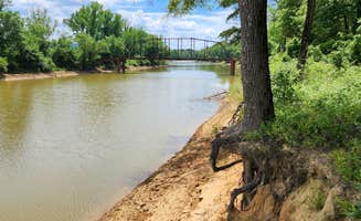
Fishing access points: Jack Creek offers several dispersed camping locations with pathways to water for fishing. "This is a large wooded dispersed campsite that has a short path down to Jack Creek. Depending on the water level, fishing and wading are possible at the creek," notes Fred S. about Jack Creek Dispersed.

Trail exploration: The Sugar Creek hiking trail provides moderate hiking opportunities accessible from several nearby dispersed sites. Campers staying at Jack Creek area sites can easily reach this trail for day hikes through dense forest and along seasonal waterways.

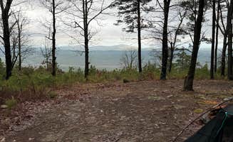
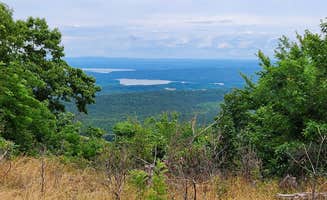
Wildlife observation: The Fourche Mountain area offers excellent wildlife viewing opportunities. "This section of the National Forest offers two hours gravel road through the forest... On the path offers hidden creek waterfalls, lots of one way bridge and a serenity drive," writes Jeff P. about Ouachita National Forest Fourche Mountain.

What campers like

Privacy and seclusion: The dispersed sites off Girard Road provide isolation from other campers. "This site is set off from the forest road on a narrow undesignated dirt track which is easy to miss. It is a small site with enough room for one vehicle," explains Fred S. about Girard Rd/Forest Road 20 Dispersed.

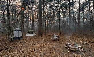
Basic amenities: Some primitive camping areas feature simple improvements. Turner Creek Road offers "Very secluded spot no amenities just a rock fire ring. Very peaceful," according to Jacob.

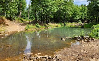
Swimming opportunities: The Jack Creek area contains several locations suitable for cooling off during hot months. Multiple dispersed sites are within short driving distance of swimming holes along the various creeks and streams, though water levels vary seasonally.

What you should know

Bear safety practices: The entire region is black bear habitat requiring proper food storage. At Irons Fork, a camper reported: "We were the only campers had a great spot on the water for a morning shower... It is bear country and others trash was gone through by wildlife in the bathroom," notes Charity S. about Irons Fork.

Cell coverage limitations: Service varies significantly throughout the area. Some sites like those near Girard Road report "strong T-Mobile 5G signal" while others have no coverage whatsoever.

Bathroom facilities condition: Where pit toilets exist, maintenance is inconsistent. One camper at Irons Fork stated, "I used my own pop up toilet as there's is not close to being clean," while another noted, "there are bathrooms but they are RANK so just pee n poop in the woods."

Tips for camping with families

Swimming access evaluation: When camping with children, scout water access points first. At certain locations in Mena Arkansas, "secluded spot for Privacy" means you can enjoy water activities without disturbing other campers, according to Ernest W.

Location verification: Coordinates may be inaccurate for some sites. A camper at Fourche Mountain advised: "The coordinates placed me at a gated forest road. There is no dispersed campsite here. There is also no river access or creeks at this location."

Security considerations: Be mindful of belongings security at more accessible areas. One Irons Fork camper reported: "figured it might be some local early morning fishers or something. saw them leave after an hour tho, and come to find they STOLE OUR PADLOCKED COOLER."
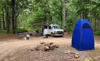
Tips from RVers

Road accessibility assessment: Accurately assess vehicle capabilities against road conditions. Carlos P. advises about Blue Knob Road: "I have a CDL and back stuff all day. Don't try to pull in. Back in off the Buck Mountain."

Site leveling requirements: Terrain throughout the area is uneven. At Fourche Mountain, one camper notes, "site is a little uneven, so chocks were helpful" for stabilizing their rig.

Seasonal road conditions: Forest roads deteriorate significantly during and after rain. Most primitive camping locations around Pencil Bluff require higher clearance vehicles after precipitation, with many becoming impassable for trailers or larger RVs during wet periods.

Frequently Asked Questions

Which is the most popular dispersed campsite near Pencil Bluff, AR?

According to TheDyrt.com, the most popular dispersed campground near Pencil Bluff, AR is Blue Knob Road in Ouachita National Forest with a 4-star rating from 2 reviews.

What is the best site to find dispersed camping near Pencil Bluff, AR?

TheDyrt.com has all 35 dispersed camping locations near Pencil Bluff, AR, with real photos and reviews from campers.