Best Dispersed Camping near Marble Falls, AR

Dispersed camping opportunities near Marble Falls, Arkansas are primarily found within the Ozark National Forest and Buffalo National River areas. Sam's Throne Recreation Area offers free primitive camping with vault toilets but no running water. According to reviews, "Sites are separated by trees, so some privacy" and "beautiful cliff views are a short walk away." Gene Rush Wildlife Management Area provides designated camping sites, but requires a $5 camping permit from the Arkansas Game and Fish Commission. Woolum Dispersed Area along Buffalo National River features riverside camping with basic toilet facilities.

Road conditions vary significantly throughout the region. Many forest roads are gravel with varying degrees of maintenance. Several campers noted that "low clearance vehicles may high center in one or two spots" on some access roads, particularly after heavy rains. Morgan Mountain Road near Spy Rock has "some ruts from previous rains" but remains passable for most vehicles when driven slowly. High clearance vehicles are recommended for accessing more remote sites, especially during wet seasons.

Most dispersed sites feature established rock fire rings, but no potable water or trash service. Pack-in, pack-out principles apply throughout the area. Cell service is inconsistent; some sites report good coverage while others have none. Wildlife considerations include bears in some areas, particularly near Sam's Throne where food storage precautions are advised. Poison ivy is common in the surrounding vegetation at many sites. Seasonal factors affect camping experience significantly - fall offers spectacular colors, while summer requires insect protection. During hunting seasons (September through May), campers should be aware of increased activity in Wildlife Management Areas.

Best Dispersed Sites Near Marble Falls, Arkansas (24)

    1. Sam's Throne Recreation Area

    17 Reviews
    Mount Judea, AR
    15 miles
    Website
    +1 (870) 446-5122

    "There are surrounding trails that lead to some nice spots for a stunning sunset. These seem to be free established campgrounds, not dispersed."

    "There are a few bears in the region so I would hang my food just to be safe. There aren't any specific spots for RV's but there are a few cleared areas with room to park an RV or trailer."

    2. Gene Rush Wildlife Management Area

    4 Reviews
    Vendor, AR
    11 miles

    "100% of Wildlife Management Areas in the state of Arkansas require a Hunting license or WMA camping permit purchased though Arkansas Game and Fish."

    "Spoke with Arkansas Game and Fishing Commission Ranger. No despersal camping but you can camp in the 2 designated campsites. Well designated, my post is on the further east site from Carver."

    3. Woolum Dispersed Area — Buffalo National River

    8 Reviews
    St. Joe, AR
    17 miles
    Website

    "No potable water and no trash service. Solar recharging and Starlink connectivity are possible. I received spotty T-Mobile 2G and 4G LTE service."

    "So many options to make your home away from home! Grassy meadows or river side oasis, you choose! This is definitely the place to go to enjoy magnificent scenery and not be distracted by technology."

    4. Buffalo Creek Trail

    1 Review
    Pettigrew, AR
    25 miles

    "The final half mile of Madison/404 was too steep and rough to proceed. Cavern Mountain Rd 5 was good. Additionally, Google routed us a bunch of dirt roads to get here."

    5. Falling Water Creek

    1 Review
    Witts Springs, AR
    27 miles

    6. Morgan Mtn Rd/Spy Rock Dispersed

    6 Reviews
    St. Paul, AR
    44 miles

    "Various camp sites along a dirt road, that my AWD Equinox made it fine. Just go slow, as there are some ruts from previous rains.
    There are various outfitters along the way to the dirt road."

    "GPS brought us directly to the site. The gravel road has some ruuts but it you take your time small SVUs can make it fine. Beautiful over look and clean campsite."

    7. Hercules-Glades Wilderness Area

    4 Reviews
    Bradleyville, MO
    44 miles
    Website

    "This area is a wilderness area so camping is plentiful.  However in this particular are there is no organized campsite specifically.  "

    "Hercules Glades Wilderness Area is part of mark Twain National Forest. It's a bit off the beaten path, but worth it for a day hike or a bit of backpacking."

    9. Hercules Glades (Watch Tower)

    4 Reviews
    Bradleyville, MO
    44 miles

    "Free national forest primitive campground. Walk-in tent sites, but was able to find a site at the far end to park my van at the site. It was at the Long Creek Trailhead."

    "We got here on a pretty hilly/twisty road late at night, found a spot close to the trailhead and had a quiet, peaceful night sleep. We saw just one other camper with a trailer close to the inlet."

Show More
Showing results 1-10 of 24 campgrounds

2025 Detourist Giveaway

Presented byToyota Trucks

Review Campgrounds. Win Prizes.

Enter to Win


Dispersed Camping Reviews near Marble Falls, AR

52 Reviews of 24 Marble Falls Campgrounds


  • Fred S.The Dyrt PRO User
    Jul. 7, 2024

    Brock Creek - Charleston Rd Dispersed, Ozark NF, AR

    Nice Dispersed Site Above Brock Creek

    Not sure if the location pin is correct, so here are the coordinates: 35.49995, -92.80930. A large, wooded dispersed site situated above Brock Creek off of Charleston Road in a popular national forest OHV and multi-use trail area. Charleston Road is a wide, well maintained gravel road. The dispersed site can accommodate 2 or 3 vehicles - campervan size and smaller. There are 2 access driveways into the site. Access for a truck camper is tight due to the location of trees on the site. Access for 2WD low clearance vehicles may be rough due to some erosion. The dispersed site is a dirt surface with some embedded rocks jutting out. Some leveling may be required depending where the rig is parked. Tent camping is possible. There is a vehicle turnaround at the rear of the site. The site is shaded, so solar charging is limited. Except for a little bit of glass and some bullet shell casings scattered about, the site was clean at the time of my visit. The site has a large rock fire ring. There is a wide track that leads off the site toward the south along and above the creek. This track does not appears on any of the current forest service maps (including MVUM) that I have, so I'm assuming that it is not a legal motorized vehicle track. The track is hikeable. The site is convenient to OHV and multi-use trails. It was a pretty site during my summertime visit, but I bet it's beautiful during the Fall season. It is set back from Charleston Road. It is a really nice spot.

  • Fred S.The Dyrt PRO User
    Jan. 6, 2025

    FR1802A, Meadows Knob Rd Dispersed

    Secluded, Light Usage, Dispersed Camping in the Ozarks

    Coordinates: 35.58695,-93.20723. Camped here Dec 29, 2024. Set well off of Meadows Knob Rd. Expect pinstriping along the access track to this secluded dispersed campsite. FR1802A toward the site has some erosion; low clearance vehicles may high center in one or two spots. The main forest road into this part of the Ozark National Forest is okay. The campsite is in open area, located in an old clear cut area. There is a partial view of the distant mountains. The site is a level, dirt surface. Not a large site; okay for one rig. Tent camping possible. No nearby mature trees for hammock camping. The site is overgrown with grass and weeds; a weed whacker is needed to clear the rock fire ring. There is a spot on the ground where a previous campfire was made. Good AT&T and T-Mobile 5G service. No shade; access to Starlink is possible. No hiking trails, although there is a 2-track for hiking that leads down into Graves Creek Canyon and some unnamed waterfalls. The hike along this trck is nice. This is not a pretty dispersed site, but it is well off of the main forest road; very private. Access to the site may be difficult for some vehicles. High clearance 4x4 vehicles should have no problems.

  • Fred S.The Dyrt PRO User
    Oct. 28, 2025

    Hercules Glades (Watch Tower)

    Nice campground with access to trails

    Camped here in mid-October 2025. Free national forest primitive campground. Walk-in tent sites, but was able to find a site at the far end to park my van at the site. It was at the Long Creek Trailhead. It was mid-week, so it was quiet and peaceful here. Only one other camper here during our visit who car-camped in a parking lot. Sites included a metal fire ring and table; some with tent pads. Hammock camping is possible depending on the site. My site had a grass and dirt surface. The vault toilet was clean and equiped with tp. No potable water. Hiking into the Hecules Glades Wilderness Area was wonderful. The trails into the wilderness area appear to be open to hikers, backpackers, hunters and equestrian riding. Hitching rails are available at the campground. Access to the campground on the forest road was good; a 2wd passenger car should be able to make it here. Overall, a nice, peaceful overnight stay.

  • Fred S.The Dyrt PRO User
    May. 26, 2022

    Middle Fork Dispersed Site AR Ozarks

    Creekside Dispersed Site, Middle Fork Illinois Bayou

    Large clearing along the Middle Fork of the Illinois Bayou. Located on Middle Fork Road, about a 1/4 mile in from AR Hwy 27, near Hector, AR. The site is on national forest land and appears to be popular. It's large enough for 3 car/truck/campervan rigs. Area is level for rigs & tents, although the ground is mostly hard buried gravel - maybe uncomfortable to sleep on without pads. Three large puddles on the site. Three ways to enter the site from  Middle Fork Road. Middle Fork Rd itself can easily accommodate 2wd passenger vehicles. Other dispersed sites further down the road along the creek. The site is not pristine, but it's nice to camp close to the bayou. Very peaceful, but there is occasional faint truck noise from Hwy 27. A half dozen or so vehicles passed by, some were residents who live further down the road. No facilities; need to bring your own water. No trash pickup; pack in, pack out.

  • Fred S.The Dyrt PRO User
    Jul. 6, 2024

    Group Dispersed, Charleston Road, Ozark NF, AR

    Large Group Dispersed Camping

    Coordinates: 35.50873, -92.81549. Group dispersed site located less than a 1/4-mile south of the Zing Trailhead on Charleston Road. Charleston Road is a wide, well maintained gravel road located in a popular national forest OHV area. This dispersed site is a level with a dirt and grass surface. The site can accomodate multiple vehicles; tent camping is possible. There is a large rock fire ring at the rear of the site. The site is open with little shade, making recharging with solar panels possible. Other than accommodating a group of OHV and offroad enthusiasts, and stargazing at night, there is nothing remarkable about this campsite.

  • Crystal C.The Dyrt PRO User
    Jun. 1, 2020

    Hercules-Glades Wilderness Area

    Hike in and camp, or just hike for day use!!

    This area is a wilderness area so camping is plentiful.  However in this particular are there is no organized campsite specifically.  Instead there are several areas where you can with permissions hike in and stay.  

    My suggestion for camping along this area are to check with local restrictions, there are some that you will want to make sure you know first hand.   Sometimes fire restrictions do change and these can be found at the beginning of the trails on the kiosks.   Some areas also are not permitted for overnight parking so you want to check those out before venturing into the wilderness for a lengthy time.

    Check with rangers of the area to make sure you are not in a register only or permit only area for camping!!  Very important in this region.

    Bring everything and then plot your course.

    The 4 mile hike is amazing and has many beautiful view points however it is also quite treacherous in some areas.    This area is also one which you will find many snakes lurking during warmer months so beware!!!!   

    I always suggest on wilderness hikes to not hike alone or camp alone but this one I found to be more problematic with limited to no cell service for assistance should you encounter danger.   

    Be careful but have fun!!!

  • Fred S.The Dyrt PRO User
    Jul. 4, 2024

    Charleston Road Dispersed, Ozark NF, AR

    Convenient to National Forest OHV Area

    Pin location may not be correct, so here are the coordinates: 35.52534, -92.83158. Located on Charleston Road in a popular national forest OHV area - 1/2 mile southeast of the Mountain Man Trailhead. Charleston Road is a well maintained gravel road. The site is at the beginning of an old unnamed, closed, dirt track - close to Charleston Road. The site has a dirt surface; not quite level, but more level toward the rear. It is a pull-in site which can accommodate one campervan and smaller. Tent camping is possible. The site is mostly shaded. There is poison ivy around the perimeter of the site. The site includes a large rock fire ring. Except for a little bit of trash in the fire ring, the site was pretty much clean. The old track is gated just past the site,; the track is hikeable, leading up to the northern-most Stoebuck Mountain (there are two "Stoebuck Mountains" in this area). Except for being convenient to OHV trails, there is nothing remarkable about this dispersed site. It is good for an overnight stay.

  • T
    Nov. 29, 2017

    Hercules-Glades Wilderness Area

    Nicely private, but not a lot of scenery

    Hercules Glades Wilderness Area is part of mark Twain National Forest. It's a bit off the beaten path, but worth it for a day hike or a bit of backpacking.

    Since it's wilderness area, you can camp just about anywhere with few restrictions. There are a few primitive sites at the trailhead, no water or toilets.

    A few hundred yards from the Coy Bald Trailhead there is a fork in the trail. Going left gets you to the falls and the majority of the camp sites with the shortest route, about three miles.

    The trail is pretty rough and rocky with moderate elevation changes. I'd rate it on the low side of moderate difficulty.

    About a mile in you'll cross the river for the first time. There are camp sites with fire rings on both sides of the river. This is a scenic area with bluffs on one side of the river, but forested, so no views to speak of.

    About three miles in, you'll cross the river the second time. There are a number of camping areas with fire rings along the river.

    Downstream a few hundred feet are the falls that most people go to see. Unfortunately for us, there wasn't enough water for them to be running. There was enough water to wade around in and soak the feet. It was quite nice!

    The area is pretty and quiet, we saw only a handful of people in the two days we were there. The only issue was the ticks, they were the worst I'd dealt with in some time.

    All in all, a nice hike and a nice bit if camping. I'd go back to see the falls again.

  • Fred S.The Dyrt PRO User
    Nov. 10, 2025

    Woolum Dispersed Area — Buffalo National River

    Easy access to the Buffalo National River

    Camped here mid-week in early November, 2025. Came here to camp while doing some smallmouth bass fishing on the Buffalo River. Quickly found a large, open, level site with a rock fire ring on a grassy field. This site was large enough to accomodate multiple vehicles and horse trailers. I did not try to find a spot on the river bank, although the river bank appeared easy to access. Only two other camping groups were here during my stay - far enough away that I couldn't hear them. Including the one at the day use parking lot, there are three clean and supplied vault toilets here. The campground appeared well maintained. No potable water and no trash service. Solar recharging and Starlink connectivity are possible. I received spotty T-Mobile 2G and 4G LTE service. This primitive campground is convenient for kayakers and canoers, as well as for overlanders and equestrian campers. I met a backpacker who just came off of the Ozark Highland Trail across the river and was camping on the rocky river bank. I recommend, especially for those driving 2WD passenger vehicles, accessing the campground using Searcy County Road 15 - not CR14. Although open during my time here, narrow CR14 still had some damage from recent landslides which resulted in rough driving conditions (although, high clearance, 4x4 vehicles should have no problems). Overall, I enjoyed camping here, and I'm looking forward to returning to this beautiful area in the Arkansas Ozarks.


Guide to Marble Falls

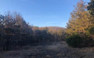
Rustic camping near Marble Falls, Arkansas centers around the wooded highlands of the Ozark Mountains at elevations of 1,000-2,000 feet. The area features numerous limestone bluffs and creeks that cut through the forested terrain. Summer temperatures often reach 90°F with high humidity, while fall brings cooler temperatures in the 60-70°F range with colorful foliage.

What to do

Hiking to waterfalls: Several waterfalls can be found within driving distance of Marble Falls, particularly after rainfall. At Morgan Mtn Rd/Spy Rock Dispersed, "Spy Rock overlook is down the road and the view is spectacular. There are also nearby waterfalls to hike to," according to one camper.

Rock climbing: The area offers multiple climbing opportunities for different skill levels. Sam's Throne Recreation Area is particularly popular for this activity. One visitor noted, "Road is kinda sketchy on the way up but the bluffs are fantastic!" while another mentioned it's "a useful base if you're rock climbing. Lots of bluffs set up for that."

Star gazing: The remote nature of many campsites provides excellent dark sky viewing. A camper at Sam's Throne Recreation Area shared, "On the right dark night you can see every star in the sky," making it an ideal spot for night sky photography or simply enjoying celestial views.

What campers like

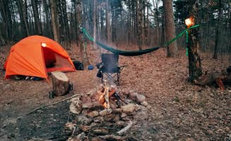
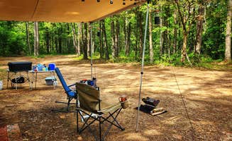
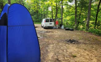
Privacy between sites: Many campers appreciate the natural separation between camping spots. According to one visitor at Woolum Dispersed Area, it's a "very primitive campground, but it's one of our favorites! We can almost always find a spot to camp and it's super easy to pull our trailer into every spot there."

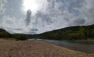
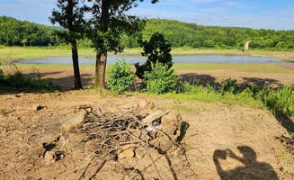
Swimming holes: Natural water features provide cooling options during hot months. A camper at Woolum Dispersed Area described it as "Quiet, spacious, with the best swimming hole!" Another visitor in May 2025 noted there was "both a rock and sand beach currently."

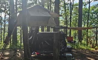
Diverse camping locations: The region offers variety in terms of terrain and views. At Adams Mountain Rd Dispersed Campsite, you'll find a "Large camping area at a high clearance ATV trailhead... Site is suitable for group dispersed camping. It looks like it can accommodate up to 3 truck camper size rigs."

What you should know

Permit requirements: Some areas require specific permits. At Gene Rush Wildlife Management Area, "100% of Wildlife Management Areas in the state of Arkansas require a Hunting license or WMA camping permit purchased through Arkansas Game and Fish," and camping permits cost $5.

Road conditions: Access to many sites requires careful driving. At Morgan Mtn Rd/Spy Rock Dispersed, one camper advised, "The gravel road has some ruts but if you take your time small SVUs can make it fine." Similarly, at Meadows Knob Rd, a visitor warned, "FR1802A toward the site has some erosion; low clearance vehicles may high center in one or two spots."

Cell service variability: Connectivity varies widely between sites. Adams Mountain Rd Dispersed Campsite has "T-Mobile 5G service (2 bars). Intermittent AT&T LTE service," while at Morgan Mtn Rd/Spy Rock, one camper reported, "T-Mobile has anywhere from one bar LTE to three bars of 5G extended to 2 bars 5G here."

Tips for camping with families

Wildlife watching: Kids often enjoy spotting local animals. At Sam's Throne Recreation Area, one camper mentioned, "Bambi and her mom also seem to live here," creating potential wildlife viewing opportunities for children.

Safety considerations: Be aware of natural hazards when camping with children. At FR1802A, Meadows Knob Rd Dispersed, a camper noted the "campsite surface is dirt, with lots of poison ivy in the surrounding foliage," requiring careful supervision of children.

Seasonal planning: Different seasons offer varied experiences for families. At Morgan Mtn Rd/Spy Rock Dispersed, campers in February reported an "overnight temp 40" while still enjoying the area, suggesting spring and fall as ideal for family camping when temperatures are milder.

Tips from RVers

Site size limitations: Most dispersed sites accommodate smaller rigs only. At Gene Rush WMA, a camper noted, "There is only a handful of sites spread throughout the WMA and you can only camp in those designated by the game and fish. This isn't the national forest, you can't just pull off and camp anywhere you please."

Leveling requirements: Terrain can be challenging for RVs. At Woolum Dispersed Area, an experienced camper mentioned, "We can almost always find a spot to camp and it's super easy to pull our trailer into every spot there."

Alternative hookup options: Most sites have no amenities, requiring self-containment. At Hercules-Glades Wilderness Area, a camper advised, "Bring everything and then plot your course," highlighting the need for complete self-sufficiency when RV camping in these remote areas.

Frequently Asked Questions

Which is the most popular dispersed campsite near Marble Falls, AR?

According to TheDyrt.com, the most popular dispersed campground near Marble Falls, AR is Sam's Throne Recreation Area with a 4.5-star rating from 17 reviews.

What is the best site to find dispersed camping near Marble Falls, AR?

TheDyrt.com has all 24 dispersed camping locations near Marble Falls, AR, with real photos and reviews from campers.