Hercules-Glades Wilderness Area, near Ava, Missouri, is a fantastic spot for those who love to hike and camp in a more rugged setting. This area offers a unique experience with the freedom to camp almost anywhere, making it perfect for adventurers looking to escape the crowds.
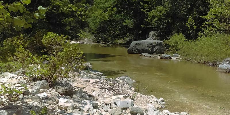
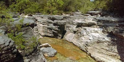
The hiking trails here are a highlight, with a popular four-mile trek that leads to stunning viewpoints and cool shut-ins, ideal for a refreshing dip. Visitors have shared that the Coy Bald hike is particularly enjoyable, with some rocky sections that add a bit of challenge but are well worth the effort for the scenery.
Keep in mind that this is a wilderness area, so amenities are minimal—there's no drinking water or toilets, and you'll need to pack out what you bring in. Reviewers have pointed out the importance of checking local regulations, especially regarding fire restrictions, before setting out. As one camper wisely noted, “Bring everything and then plot your course.”
Wildlife is abundant, and while the area is beautiful, be cautious of snakes during warmer months. If you're looking for a peaceful retreat with plenty of natural beauty, Hercules-Glades is a solid choice for your next outdoor adventure.
Description
This area is surrounded by private property - please ensure you are not on private land while hiking or camping - or if you intend to be, ask permission before doing so. And respect any "private property" signs you see.
Hercules Glades Wilderness Area is 12,413 acres of the most scenic and unique country in the Midwest. Its combination of open grassland, forested knobs, steep rocky hillsides, and narrow drainages offers unusual beauty and a measure of solitude within easy reach of wilderness lovers. The area is characterized by shallow droughty soils and limestone rock outcroppings. Eastern red cedar and oak trees are interspersed with open glades supporting native tall prairie grasses. Redbud and dogwood provide beautiful spring flowers, while smoke tree and maple put on vivid fall colors. A variety of wildlife species live within the Hercules Glades including white-tailed deer, raccoons rabbits, squirrels, turkey, quail, songbirds, lizards and snakes. Copperheads and rattlesnakes may be encountered. Roadrunners, collared lizards, tarantulas, wild hogs and black bears are some of the more uncommon wildlife residents. Limit your party size to 10 persons. No camping within 100 feet of trails, water sources and other camps.Practice Leave No Trace outdoor ethics; Never tie stock directly to trees. No motorized or mechanized equipment allowed. Trails: From the trailheads there is 32 miles of maintained trails which follows along open glades, forested ridgetops and Long Creek, the primary drainage of the area. Cross country hiking in other parts of the area is allowed. Key attractions along the trail include Long Creek Falls, panoramic views of the Ozarks countryside, and a variety of native communities including open limestone glades and mixed forests. Rating: More Difficult to Most Difficult with steep terrain, stream crossings, sparsely marked trail, and elevations from 600 to 1200 feet. Length: 32 miles Best Seasons: Fall, winter, and spring. Leave No Trace: Pack out what you pack in. Restrictions: Foot and Horse only. Safety: No drinking water is available at parking areas or along the trail; bring what you will need, or be prepared to sterilize water you find. During temperate months, be prepared for biting insects, poison ivy and high temperatures. Be advised of hunting seasons. Avoid using the trail during excessively wet periods. Surface Type: Unsurfaced, native material.
RV Road Trip Guides


Map & DirectionsHercules-Glades Wilderness Area is located in Missouri near Bradleyville
Directions
Three trailheads provide entry to the Hecules Glades Wilderness. The Hercules Tower Trailhead is located along Highway 125 8.5 miles south of Bradleyville, MO. There is a vault toilet, space for camping and parking at this location. The first part of the trail is mostly level, then it descends a slope to Long Creek. Or, take the 4-mile Pea's Hollow loop north along the hollow bottom, then back along the ridge. The Blair Ridge Trailhead is located 9.5 miles south of Bradleyville, MO on Highway 125; turn right onto Forest Road 155, go approximately 2 miles. There is only parking available at this location. The Coy Bald Trailhead is located off of Highway 160 east of Forsyth, MO 9 miles, turn left onto Forest Road 566 and go approximately 4 miles. There is parking available at this location.
Coordinates
36.68000043 N
92.8800004 W
Connectivity
 T-MobileNo CoverageVerified by 2 usersLast on 7/10/26
 VerizonLTESome Coverage
- AT&TNo CoverageVerified by 8 usersLast on 7/10/26
Connectivity
- T-MobileNo CoverageVerified by 2 usersLast on 7/10/26
- VerizonLTESome Coverage
- AT&TNo CoverageVerified by 8 usersLast on 7/10/26
Access
- Hike-InBackcountry sites.
Site Types
- Dispersed
Features
For Campers
- Alcohol
- Pets
- Fires
DISPERSED CAMPING
Enjoy dispersed camping on government land and leave no trace. Pack in and pack out. No (or limited) services at this camping area. Permit may be required.
PERMIT might be REQUIRED
We curate permit requirements across the US for our PRO members. Try PRO to see if Hercules-Glades Wilderness Area needs a permit.
Drive Time
- 1 hr 8 min from Springfield, MO
- 2 hrs 6 min from Joplin, MO
- 2 hrs 27 min from Fayetteville, AR
- 3 hrs 12 min from Fort Smith, AR


