Best Dispersed Camping near Big Flat, AR

Several free dispersed camping areas exist in the Ozark National Forest near Big Flat, Arkansas. Woolum Dispersed Area along Buffalo National River offers primitive riverside camping with vault toilets but no other amenities. Sam's Throne Recreation Area provides free sites with fire rings, vault toilets, and hiking trails with scenic bluff views. According to reviews, Sam's Throne features "private camping spots, with trees separating each site" though "no water access, so bring your own."

Gene Rush Wildlife Management Area has designated camping areas but requires a $5 camping license purchased through the Arkansas Game and Fish Commission. A visitor noted, "There are only a handful of sites spread throughout the WMA and you can only camp in those designated by the game and fish." Additional dispersed options include Matney Knob, Falling Water Creek, and several sites along Charleston Road and Brock Creek. Most areas maintain a strict pack-in/pack-out policy with 14-day camping limits. Roads to these off-grid campsites can become challenging after rain, with many requiring high-clearance vehicles during wet seasons.

Best Dispersed Sites Near Big Flat, Arkansas (14)

Show More
Showing results 1-10 of 14 campgrounds

2025 Detourist Giveaway

Presented byToyota Trucks

Review Campgrounds. Win Prizes.

Enter to Win


Dispersed Camping Reviews near Big Flat, AR

32 Reviews of 14 Big Flat Campgrounds


  • Fred S.The Dyrt PRO User
    Jul. 7, 2024

    Brock Creek - Charleston Rd Dispersed, Ozark NF, AR

    Nice Dispersed Site Above Brock Creek

    Not sure if the location pin is correct, so here are the coordinates: 35.49995, -92.80930. A large, wooded dispersed site situated above Brock Creek off of Charleston Road in a popular national forest OHV and multi-use trail area. Charleston Road is a wide, well maintained gravel road. The dispersed site can accommodate 2 or 3 vehicles - campervan size and smaller. There are 2 access driveways into the site. Access for a truck camper is tight due to the location of trees on the site. Access for 2WD low clearance vehicles may be rough due to some erosion. The dispersed site is a dirt surface with some embedded rocks jutting out. Some leveling may be required depending where the rig is parked. Tent camping is possible. There is a vehicle turnaround at the rear of the site. The site is shaded, so solar charging is limited. Except for a little bit of glass and some bullet shell casings scattered about, the site was clean at the time of my visit. The site has a large rock fire ring. There is a wide track that leads off the site toward the south along and above the creek. This track does not appears on any of the current forest service maps (including MVUM) that I have, so I'm assuming that it is not a legal motorized vehicle track. The track is hikeable. The site is convenient to OHV and multi-use trails. It was a pretty site during my summertime visit, but I bet it's beautiful during the Fall season. It is set back from Charleston Road. It is a really nice spot.

  • Fred S.The Dyrt PRO User
    May. 26, 2022

    Middle Fork Dispersed Site AR Ozarks

    Creekside Dispersed Site, Middle Fork Illinois Bayou

    Large clearing along the Middle Fork of the Illinois Bayou. Located on Middle Fork Road, about a 1/4 mile in from AR Hwy 27, near Hector, AR. The site is on national forest land and appears to be popular. It's large enough for 3 car/truck/campervan rigs. Area is level for rigs & tents, although the ground is mostly hard buried gravel - maybe uncomfortable to sleep on without pads. Three large puddles on the site. Three ways to enter the site from  Middle Fork Road. Middle Fork Rd itself can easily accommodate 2wd passenger vehicles. Other dispersed sites further down the road along the creek. The site is not pristine, but it's nice to camp close to the bayou. Very peaceful, but there is occasional faint truck noise from Hwy 27. A half dozen or so vehicles passed by, some were residents who live further down the road. No facilities; need to bring your own water. No trash pickup; pack in, pack out.

  • Fred S.The Dyrt PRO User
    Jul. 6, 2024

    Group Dispersed, Charleston Road, Ozark NF, AR

    Large Group Dispersed Camping

    Coordinates: 35.50873, -92.81549. Group dispersed site located less than a 1/4-mile south of the Zing Trailhead on Charleston Road. Charleston Road is a wide, well maintained gravel road located in a popular national forest OHV area. This dispersed site is a level with a dirt and grass surface. The site can accomodate multiple vehicles; tent camping is possible. There is a large rock fire ring at the rear of the site. The site is open with little shade, making recharging with solar panels possible. Other than accommodating a group of OHV and offroad enthusiasts, and stargazing at night, there is nothing remarkable about this campsite.

  • Fred S.The Dyrt PRO User
    Jul. 4, 2024

    Charleston Road Dispersed, Ozark NF, AR

    Convenient to National Forest OHV Area

    Pin location may not be correct, so here are the coordinates: 35.52534, -92.83158. Located on Charleston Road in a popular national forest OHV area - 1/2 mile southeast of the Mountain Man Trailhead. Charleston Road is a well maintained gravel road. The site is at the beginning of an old unnamed, closed, dirt track - close to Charleston Road. The site has a dirt surface; not quite level, but more level toward the rear. It is a pull-in site which can accommodate one campervan and smaller. Tent camping is possible. The site is mostly shaded. There is poison ivy around the perimeter of the site. The site includes a large rock fire ring. Except for a little bit of trash in the fire ring, the site was pretty much clean. The old track is gated just past the site,; the track is hikeable, leading up to the northern-most Stoebuck Mountain (there are two "Stoebuck Mountains" in this area). Except for being convenient to OHV trails, there is nothing remarkable about this dispersed site. It is good for an overnight stay.

  • Fred S.The Dyrt PRO User
    Jul. 2, 2024

    Austin Trailhead Dispersed, Wilderness Trail Rd, Ozark NF, AR

    Dispersed camping convenient to OHV/multi-use national forest trails

    Not sure if the pin location is correct, so here are the exact coordinates: 35.53654, -92.80322.  Small dispersed campsite just off Wilderness Trail Road. Wilderness Trail Road is a wide gravel country road located in a popular national forest OHV area. More specifically, the site is located on multi-use/OHV trail Brock Creek #42, Forest Road 2321 - just a few hundred feet south of Wilderness Trail (not in the trailhead parking lot, where camping is not allowed). Its a small, level dirt site, mostly shaded in a small clearing in the trees, close to the track - not private. It has a small rock fire ring. Tent camping is possible. It's a pull-in site which can accommodate one vehicle - truck camper and smaller. Except for being convenient to OHV trails, there is nothing remarkable about this dispersed site.

  • Fred S.The Dyrt PRO User
    Jul. 9, 2024

    Brock Creek Lake View Dispersed, Ozark NF, AR

    Lake View Dispersed Camping

    Coordinates: 35.49123, -92.80548. Large open dispersed site set back from Charleston Road, just north of Bell Rd (Forest Road 1334). Located in a popular national forest OHV and multi-use trails area. Charleston Road is a wide, well-maintained gravel road. Access to the site from Charleston Road is on a 400 foot long narrow dirt track; pinstripping is possible. The dispersed site has a dirt surface with some embedded rocks. It's on a rise above the lake, offering a nice view. Solar recharging is possible in this open site. The site is on what appears to be a parking area along an old dirt track; this track appears as an older section of Charleston Rd on some maps. There is a dirt ramp into the lake. There is room for multiple rigs at the campsite. Some leveling may be required depending on the spot the vehicle is parked. There are two rock fire rings - one large and one small. Tent Camping is possible near the fire rings. The lake was drained at the time of my visit; otherwise, it's a really nice view.

  • Fred S.The Dyrt PRO User
    Nov. 10, 2025

    Woolum Dispersed Area — Buffalo National River

    Easy access to the Buffalo National River

    Camped here mid-week in early November, 2025. Came here to camp while doing some smallmouth bass fishing on the Buffalo River. Quickly found a large, open, level site with a rock fire ring on a grassy field. This site was large enough to accomodate multiple vehicles and horse trailers. I did not try to find a spot on the river bank, although the river bank appeared easy to access. Only two other camping groups were here during my stay - far enough away that I couldn't hear them. Including the one at the day use parking lot, there are three clean and supplied vault toilets here. The campground appeared well maintained. No potable water and no trash service. Solar recharging and Starlink connectivity are possible. I received spotty T-Mobile 2G and 4G LTE service. This primitive campground is convenient for kayakers and canoers, as well as for overlanders and equestrian campers. I met a backpacker who just came off of the Ozark Highland Trail across the river and was camping on the rocky river bank. I recommend, especially for those driving 2WD passenger vehicles, accessing the campground using Searcy County Road 15 - not CR14. Although open during my time here, narrow CR14 still had some damage from recent landslides which resulted in rough driving conditions (although, high clearance, 4x4 vehicles should have no problems). Overall, I enjoyed camping here, and I'm looking forward to returning to this beautiful area in the Arkansas Ozarks.

  • Fred S.The Dyrt PRO User
    Jul. 10, 2024

    Tackett Mountain Road Dispersed, Ozark NF, AR

    Nice site to hang-out in

    The pin location may not be accurate, so here are the coordinates: 35.44497, -92.76914. This is a small dispersed campsite with a level dirt surface, just big enough to accommodate one vehicle - truck camper and smaller. Tent and hammock camping is possible. The site is tucked into the trees, and it has a clean rock fire ring. The site is located on a dirt track - Forest Road 93021L, which is off of Tackett Mountain Road - Forest Road 1319. The site offers privacy from Tackett Mountain Rd, but it is close to Forest Road 93021L. Tackett Mountain Rd is a wide, well maintained, gravel forest road. Access to 93021L off of Tackett Mountain Road is up a slight incline with some gravel cover. Once up the incline, the track becomes dirt, goes through a clearing and heads into the woods where the dispersed site is located on the right. One can camp in the clearing; there is a small rock fire ring that is overgrown with grass and weeds, but the site in this review is nicer. The clearing was logged long ago where one may find some pieces of firewood. Some solar charging may be possible depending on the time of day and if the solar panels can be set up along the track in front of the site. There are no hiking trails here, although one can take a stroll along FR90231L which is less than a half-mile long. Even though there is not much to do around here, it's a nice place to simply hang out in. I liked it.

  • Candace R.
    Sep. 28, 2021

    Woolum Dispersed Area — Buffalo National River

    Buggy but Beautiful

    So many options to make your home away from home! Grassy meadows or river side oasis, you choose! This is definitely the place to go to enjoy magnificent scenery and not be distracted by technology. Late September visit means the river is low, nights are cool and days are filled with sunshine. Bring the bug spray and sunscreen.


Guide to Big Flat

Dispersed camping options near Big Flat, Arkansas offer secluded forest retreats in the Ozark National Forest at elevations ranging from 1,000 to 2,500 feet. The region experiences four distinct seasons with summer temperatures averaging 85-95°F and winter lows frequently dropping below freezing. Most rustic campsites in this area require visitors to be entirely self-sufficient with water and supplies.

What to do

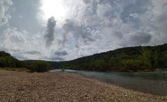
Riverside relaxation: Woolum Dispersed Area provides excellent swimming opportunities during warmer months. "Right on the river with both a rock and sand beach currently... Only one other camper that's at the other end of the campground on memorial weekend," notes a visitor to Woolum. The Buffalo River access makes this location ideal for cooling off.

Rock climbing: The bluffs around Sam's Throne Recreation Area are popular with climbers of various skill levels. "The views are 100% worth it," states one camper. Another mentions, "Road is kinda sketchy on the way up but the bluffs are fantastic!" Climbing routes vary from beginner to advanced.

Hiking trails: Multiple walking paths connect campsites to scenic overlooks. One camper reports, "There are a number of trails outside the main established trails. Our second day there we spent eight hours skirting along the bluffs and exploring what looked like beautiful fairy lands." Many trails remain accessible year-round but become muddy after rain.

What campers like

Privacy between sites: Campers frequently mention site separation at various locations. At Sam's Throne, "Sites are separated by trees, so some privacy," according to one review. The natural barriers create personal space even when campgrounds are busy.

Wildlife viewing: The natural setting provides opportunities to observe local fauna. One camper at Sam's Throne notes, "Bambi and her mom also seem to live here," referring to deer that frequent the area. Early morning and dusk offer best viewing times.

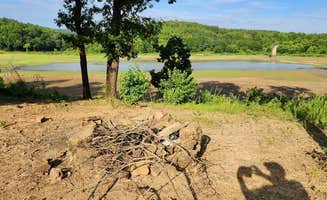
Night sky visibility: Brock Creek Lake View and other sites away from light pollution provide stellar stargazing. "On the right dark night you can see every star in the sky," explains one camper. Clear nights during new moon phases offer optimal viewing conditions.

Seasonal beauty: The changing seasons dramatically transform the landscape. "This was a beautiful park with a campground that we really enjoyed riding around and exploring. We were there in April and the dogwoods were blooming," shares one visitor about Woolum. Fall colors peak in late October to early November.

What you should know

Permit requirements: Some areas require specific permits or licenses. The Gene Rush Wildlife Management Area requires a "$5 camping license purchased through the Arkansas Game and Fish Commission." A reviewer explains, "100% of Wildlife Management Areas in the state of Arkansas require a Hunting license or WMA camping permit purchased though Arkansas Game and Fish."

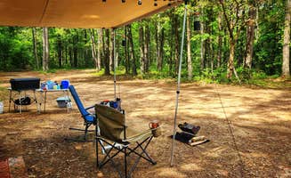
Bathroom facilities: Toilet availability varies significantly between sites. "This is a very primitive campground... with vault toilets only and no running water," notes one Sam's Throne visitor. Another adds, "There are two vault bathrooms, no tables provided, and not trash."

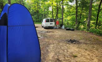
Road conditions: Access to many sites requires careful driving, especially after wet weather. "The dispersed site can accommodate 2 or 3 vehicles - campervan size and smaller... Access for 2WD low clearance vehicles may be rough due to some erosion," cautions a reviewer at Brock Creek.

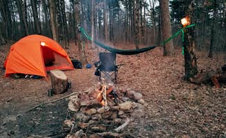
Fire regulations: Fire rings are available at most sites, but restrictions may apply seasonally. "The site has a dirt surface with some embedded rocks jutting out... The site has a large rock fire ring," notes a camper at Brock Creek - Charleston Road. Always check current fire restrictions before your trip.

Tips for camping with families

Swimming spots: The Buffalo River provides family-friendly water recreation. "We love the peacefulness of this place and will continue coming back," mentions a Woolum camper. "This is a very primitive campground, but it's one of our favorites! We can almost always find a spot to camp and it's super easy to pull our trailer into every spot there."

Bug protection: Insect repellent is essential during warmer months. "Bring the bug spray and sunscreen," advises one visitor. Ticks are common from April through October, requiring regular checks after outdoor activities.

Weather preparation: Tackett Mountain Road and similar rustic camping areas near Big Flat require planning for rapid weather changes. "Late September visit means the river is low, nights are cool and days are filled with sunshine," notes one reviewer. Pack layers even in summer when temperature swings can exceed 30 degrees between day and night.

Tips from RVers

Site limitations: Most dispersed sites accommodate smaller rigs only. "It's a small, level dirt surface, just big enough to accommodate one vehicle - truck camper and smaller," reports a camper at Tackett Mountain Road. Measure your vehicle length before attempting access.

Leveling needs: Uneven terrain requires preparation. "The dispersed site has a dirt surface with some embedded rocks. It's on a rise above the lake... Some leveling may be required depending on the spot the vehicle is parked," advises a visitor to Brock Creek Lake View.

Water planning: No hookups means bringing all water needed. "No water access, so bring your own," states a Sam's Throne visitor. Most campers recommend 1-2 gallons per person per day minimum.

Frequently Asked Questions

Which is the most popular dispersed campsite near Big Flat, AR?

According to TheDyrt.com, the most popular dispersed campground near Big Flat, AR is Matney Knob disbursed with a 3-star rating from 1 review.

What is the best site to find dispersed camping near Big Flat, AR?

TheDyrt.com has all 14 dispersed camping locations near Big Flat, AR, with real photos and reviews from campers.