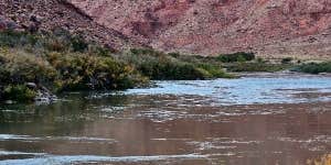
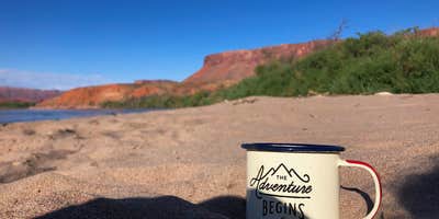
BLM Lower Onion Creek Camping Area, near Moab, Utah, is a scenic retreat that offers a unique camping experience right next to the Colorado River. With stunning views of the surrounding canyons and mesas, it’s a great place to soak in the beauty of the desert landscape.
This area is perfect for those who enjoy a more rustic experience, as it features basic amenities like toilets but lacks drinking water and electric hookups. Visitors have raved about the picturesque setting, with one camper noting, “Great views in every direction.” If you’re planning to camp here, be ready for chilly nights and some wind, as it can get a bit breezy after sunset.
For adventure seekers, the campground is a fantastic launch point for rafting trips. One reviewer shared their experience of floating down the river and camping on a sandy beach, saying it made for a “starry night and an early morning enjoying coffee and the views.” Whether you’re in a tent or RV, you’ll find plenty of opportunities to explore the nearby river and enjoy the outdoors.
While there are no picnic tables or fire pits, the natural beauty and tranquility of the area make it a worthwhile destination for those looking to escape the hustle and bustle. Just remember to pack out what you pack in, as there’s no trash service here. If you’re after a peaceful getaway with breathtaking scenery, this camping area is definitely worth considering.
RV Road Trip Guides


Map & DirectionsBLM Lower Onion Creek Camping Area is located in Utah near Castle Valley
Directions
The Lower Onion Creek Group Campsite is located approximately 23 miles east of Moab, Utah. Travel on Utah Highway 128 to a sign that says “Fisher Towers”. The Lower Onion Creek Road is directly opposite the Fisher Towers road. Turn north (toward the river) onto the Lower Onion Creek Road. There is no sign marking this road. (Note: the sign on the highway that says “Onion Creek” does NOT mark the road that you want.) Travel on this graded road toward the river; the group site is located at the end of the road.
Coordinates
38.74257242 N
109.34786518 W
Connectivity
 T-MobileNo Coverage
- VerizonNo CoverageVerified by 1 userLast on 7/4/26
- AT&TNo CoverageVerified by 1 user
Connectivity
- T-MobileNo Coverage
- VerizonNo CoverageVerified by 1 userLast on 7/4/26
- AT&TNo CoverageVerified by 1 user
Access
- Drive-InPark next to your site
- Walk-InPark in a lot, walk to your site.
- Boat-InSites accessible by watercraft.
Site Types
- Tent Sites
- Standard (Tent/RV)
- Group
Features
For Campers
- Toilets
- Alcohol
- Pets
Drive Time
- 1 hr 13 min from Grand Junction, CO
- 3 hrs 13 min from Provo, UT
- 3 hrs 32 min from Farmington, NM
- 3 hrs 44 min from Salt Lake City, UT


