Best Dispersed Camping near Maryland, NY
Planning a dispersed camping trip near Maryland? With The Dyrt, it's easy to find peaceful dispersed camping near Maryland. Search nearby dispersed campgrounds or find top-rated spots from other campers.
Primitive camping is allowed. Campsites must be at least 150 feet away from the nearest road, trail, or body of water. Camping for more than three nights or in groups of ten or more requires a permit from a Forest Ranger. More details here: https://www.dec.ny.gov/outdoor/41282.html
Primitive camping is allowed on many DEC lands, including Forest Preserve lands in the Catskills and Adirondacks, as well as on State Forest lands outside the Preserve. Primitive camping is prohibited on Unique Areas, Wildlife Management Areas, and a few other categories of state land.
Where to Set Up Camp The best place to camp is at designated primitive tent sites. These sites are typically flatter than other areas and have deeper, harder soils more resistant to heavy use and erosion, minimizing the impacts of camping. Many sites have nearby pit privies and rock fire rings.
Yellow and black camp here marker attached to a tree "Camp Here" marker Campers are encouraged to use designated tent sites. They are often close to trails and provide views of ponds, lakes, streams or rivers. These can be a source of water when properly treated.
All designated primitive tent sites have yellow and black "Camp Here" markers. Many sites on lakes and ponds are identified by a yellow number against a dark brown wooden plaque typically attached to a tree near the water's edge.
Description
Permits for Peekamoose Blue Hole are only necessary on weekends and holidays from mid-May through mid-September of each year. Permits are available as late as a day in advance, but no more than 7 days in advance. There is a limit of 25 permits issued per day. The Blue Hole is a day-use area and is part of the Rondout Creek, which flows through the Peekamoose Valley to the Rondout Reservoir. The reservoir provides almost half of the drinking water for more than 9 million people in the New York City metropolitan area. Help us protect the area - and your drinking water - by observing these regulations: Use the portable toilets for all human waste. If you carry it in, carry it out - use the dumpsters. Camping, fires and portable generators are allowed only at designated campsites downstream of the Blue Hole. No radios and other audio devices. No glass containers. Except for the designated camping sites, the Peekamoose Corridor is open to the public from onehalf hour before sunrise until one-half hour after sunset.
Primitive camping is allowed. Campsites must be at least 150 feet away from the nearest road, trail, or body of water. Camping for more than three nights or in groups of ten or more requires a permit from a Forest Ranger. More details here: https://www.dec.ny.gov/outdoor/41282.html
Primitive camping is allowed on many DEC lands, including Forest Preserve lands in the Catskills and Adirondacks, as well as on State Forest lands outside the Preserve. Primitive camping is prohibited on Unique Areas, Wildlife Management Areas, and a few other categories of state land.
Where to Set Up Camp The best place to camp is at designated primitive tent sites. These sites are typically flatter than other areas and have deeper, harder soils more resistant to heavy use and erosion, minimizing the impacts of camping. Many sites have nearby pit privies and rock fire rings.
Yellow and black camp here marker attached to a tree "Camp Here" marker Campers are encouraged to use designated tent sites. They are often close to trails and provide views of ponds, lakes, streams or rivers. These can be a source of water when properly treated.
All designated primitive tent sites have yellow and black "Camp Here" markers. Many sites on lakes and ponds are identified by a yellow number against a dark brown wooden plaque typically attached to a tree near the water's edge.
Camping primitive camping
General information on primitive camping includes how-to and safety tips and links to rules & regulations
At large primitive camping is allowed. Campsites must be at least 150 feet away from the nearest road, trail, or body of water. Camping for more than three nights or in groups of ten or more requires a permit from a Forest Ranger.
A small rustic camp ground is also located at Balsam Pond. Camping spaces are available at no cost on a first-come, first-serve basis and there is no running water or electricity. A fire ring, outhouse, and picnic table are provided for each camping space.
Bucks Brook State Forest consists of 2,178 acres located between State highway 26 and County Highway 13 in the northwest corner of Chenango County. Popular recreational uses of this forest are hiking, nature observation and hunting.
Camping At-large primitive camping is allowed. Campsites must be at least 150 feet away from the nearest road, trail, or body of water. Camping for more than three nights or in groups of ten or more requires a permit from a Forest Ranger.
Hiking General information on hiking includes how-to and safety tips and links to rules & regulations.
A portion of the Finger Lakes Trail (leaves DEC website) traverses the forest. The trail enters the forest on the northwest side along Ratville Road and traverses east and then south to where it exits the forest on Bucks Brook Road near its junction with Rt. 26
Fishing General information on fishing includes how-to and safety tips and links to seasons, rules & regulations.
The Otselic River, which runs along Rt. 26, offers nearby trout fishing opportunities and is easily accessible due to the numerous DEC parking areas.
Fishing Access information is available. Fishing Easement information is available.
Hunting & Trapping General Information on hunting and general information on trapping includes how-to and safety tips with links to seasons, rules & regulations.
Cross-country Skiing & Snowshoeing General information on cross-country skiing and snowshoeing includes how-to and safety tips and links to rules & regulations.
Cross-country skiing and snowshoeing are permitted on all hiking trails.
Wildlife General information on animals includes links to information about birds, mammals, fish, reptiles, amphibians and insects that inhabit or migrate through the state.
The coordinates lead you to a small parking area at the end of Grover Brown Rd, which is accessed by going north from Rt 23. The road itself is in pretty rough shape, and is marked with a sign that says it is a low maintanence road. But if you follow the road north to the end, you will come to a dead end and a parking circle that gives you the option of hiking north past a gate into the state forest on a hunting trail, or west onto the Finger Lakes Trail where dispersed camping is allowed within the state forest. However, the whole road in is a tough ride, it is posted extensively en route that you are passing private property with no trespassing allowed until you see the DEC sign announcing the border of the state forest. The parking area is overgrown, the neighbors aling the road en route seem frustrated with hikers coming into the forest via this route, and the Trailhead here for the Finger Lakes Trail is blocked by downed trees that seem to have been there for a while. While you might try to hike the trail for day use, I wonder if this may not be a great place to leave your car during a foray into the woods for dispersed camping. Although the Pharsalia Forest is beautiful throughout, and dispersed camping is allowed throughout, there are better places to access it. There are also designated primitive campsites in several locations in other areas of this state forest which are worthy of your camping adventures! You
This is a primitive undeveloped campsite, there is a clearing for tenting but no potable water or amenities of any kind. The site is adjacent to a small parking area and fishing access on a really beautiful pond, which is unnamed on the map but is an impoundment of Bear Wallow Creek so it can be considered Bear Wallow Pond. I have been there in both summer, when the shoreline wildflowers are riotous, and in fall when the changing leaves are breathtaking. If you camp here, you can kayak or fish on the pond, go mountain biking on the network of state forest roads that are all part of the Pharsalia Woods Game Refuge, or access the Finger Lakes Trail or Canasawacta Creek Trail (see website for this listing for map of the refuge and more info at https://cnyhiking.com/FLT-PharsaliaWMA.htm)
You can get to the site from state highway 23 via the Benedict Hill Rd, or from the hamlet of Beaver Meadow going south and west of Cole Hill via Mud Lane. A peaceful pretty wooded spot not far from either Norwich or South Otselic for an easy overnight or weekend. I give it 4 stars not for amenities but for being an idyllic example of a dispersed primitive site
Love to camp here all year long have been coming to the area for a couple of decades now. Remote. Sometimes you never see anyone. Sometimes you see some people. You camp on the stream. There is a couple of spots
I live near this campground. I'm about a mile away and I pass it every day. It is rather remote, but it is right along West kill road. There's a stream alongside it, a fire pit, and a town about 8 mi away. It's a small town, with just a gas station store. I would not recommend this for large trailers. The site is fairly small, but it's in state park, and there's tons of walking that can be done.
Great camping spots about 1.5 mile hike in from Denning Trailhead. A lot of spots right by the river. Great spot to camp and then wake up to hike to tabletop/ peekamoose mountain. (near the top of tabletop there is also a lean-to for camping).
You have to work a bit to find info on the Whaupaunaucau state forest as a camping destination, but for primitive campers that is part of the appeal! This is a relatively unknown oasis outside of the county, but this state forest has a network of miles of trails for both hiking and criss country skiing. There is an offifical lean-to shelter and developed campsite on trail 20 (see map) but there are several primitive sites with tent site and stine fireplace, plus dispersed leave-no-trace camping is allowed anywhere in the state forest, and the possibilities are endless. Lovely hilly vistas, pondside glens, and lots of clearings near clear streams deep in this old stately forest. A great place to get away from it all for hiking and camping but it is also a fantastic place to go if you enjoy botanizing or birding, lots of unusual species to see. Just beware of ticks, they are invading the region
Bucks Brook carves a beautiful gorge through Bucks Brook State Forest before it cascades into the Otselic River. There are both state forest roads and off road trails to hike on in the area; the Bucks Brook Forest Road follows a series of small waterfalls at the bottom of the gorge to the source of the creek near the top of the ridge above it, while the Finger Lakes trail follows the brook for a short while near its mouth before climbing offroad through the ridge high above the gorge, along steep cliffs above the Otselic and west along the crest of Bucks Brook Hill. There are several very primitive tent sites along the FTL, but dispersed camping is also allowed. Two sites on the ridge near the source of the Brook are accessible by the Finger Lakes trail either from Bucks Brook Rd or Ridge Rd.
The setting is scenic and picturesque, and the winding trail can be quite a challenge if hiking the long way uphill on the FTL. An easier hike-in access is at Ridge Rd, about a 1/4 hike to the brook where there are several nice flat tent sites. The brook is beautiful and unspoiled, but this truly is primitive camping, no picnic tables, no lean-to shelter like at somecother area FTL campsites, no water source other than the brook (you should filter it even though the source is a spring near by), no latrines, no fire grates though there is a stone fire ring and you could easily build a new one of your own with stones from the brook.
Although this is an idyllic and secluded spot for primitive camping, and the hike in (either via the long or short way) is well marked and enjoyable, the campsites are really nothing more than flat ground for basic tent-sites; this location could be improved with at least a fire grate, and preferably a lean-to. Also, the parking spot for access to the trail and tentsites really needs to be upgraded; it is just a muddy turnout off the forest road. Hence the four star rating d spite the five star brook and forest! However, it should be mentioned that the amenities at campsites along other segments if the FLT have been developed and maintained not by the DEC but by different volunteer chapters of the trail organization who have adopted certain local segments; this Bucks Brook section just hasnt been adopted yet! It has the potential for being a 5-star primitive camping experience if upgraded a bit; volunteers should feel free to step forth!
For more on the Bucks Brook section if the Finger Lakes Trail, go to this link: http://www.cnyhiking.com/FLT-BucksBrookSF.htm
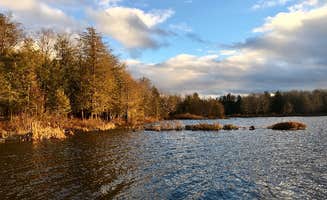
Update: since my original visit, there have been some good upgrades including new portapotty. Some of the campsites are still in need of some TLC. The location is beautiful, but the campground seems to get heavy use and has some wear and tear. Balsam Pond has a reputation as a good local fishing spot featuring trout, bass, and even tiger muskies. The pond itself is beautiful and Is one of the larger state forest ponds in the area preserved in a natural state with no shoreline development other than the small campground and the public boat launch. If you are coming for a good fishing or boating experience, you wont be disappointed as the newly built boat launch can accommodate trailers for easy access and also has a well built handicapped accessible fishing pier. Once out on the water you will enjoy good fishing or wildlife watching or paddling.
However, if you are coming here primarily for the camping experience you may be disappointed. Though the natural setting is picturesque and secluded, the campground is not well maintained. Some of the sites have new picnic tables, some have old tables that are falling apart, and some have none at all. Some have official steel fire rings, some have stone fire rings that are crumbling. All are drive in sites, some meant for trailers and others with green space for tents. A few sites are much too close to the entrance road, most are set back further in the woods, and a few are right by the lake. Unfortunately, when we were there, previous campers had strewn garbage around most of the sites; it seemed to have been there for a while so it seems there is not regular maintanence by the DEC. There is also supposed to be an outhouse at the campground, but there isnt one now. Hence my low ranking of the campground despite its nice setting.
if you would like to camp at Balsam Pond but prefer a better option than the campground, there is one paddle-in site set away from the campground where you can Leave No Trace and hopefully other like-minded campers have done the same. You are also allowed to make your own dispersed campsite at any location of your choice within the Balsam Swamp State Firest, as long as you are more than 150 feet from the lakeshore.
Frequently Asked Questions
Which is the most popular dispersed campsite near Maryland, NY?
According to TheDyrt.com, the most popular dispersed campground near Maryland, NY is Betty Brook Camp with a 4.5-star rating from 2 reviews.
What is the best site to find dispersed camping near Maryland, NY?
TheDyrt.com has all 19 dispersed camping locations near Maryland, NY, with real photos and reviews from campers.