
Four loops of forested sites spread through the trees along Michigan's western shoreline, where the road in can get rough and the cell signal drops to nearly nothing once you arrive. Lake Michigan Recreation Area sits within Manistee National Forest, open from early May through early October, and draws a steady mix of families, hikers, and backpackers who use it as a base for the Nordhouse Dunes Wilderness directly next door. Sites across all four loops, named Oak, Orchid, Hemlock, and Violet, are large and well-spaced with bear poles, fire rings with grates, and picnic tables. No showers, no electric hookups. Sites accommodate rigs up to 54 feet.
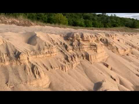
The beach is not visible from the campsites. Depending on your loop, the walk runs about five minutes on foot, and the lake itself is cold by most standards. "Water was super cold," notes Rachael S., "but, it's Michigan." The dunes above the waterline give open sightlines toward the horizon, making them a popular spot for watching the sun go down. Black flies can be a factor on some evenings, particularly before incoming weather.
The Arrowhead Trail runs through the campground and connects directly to the Nordhouse Dunes Wilderness trail network, where backpackers and day hikers share sandy forest paths. Ranger programs and an amphitheater serve families with kids. Fishing and swimming round out the on-site activity list, with Lake Michigan Campground at Manistee just over a mile north for campers who want a nearby alternative.
Crowd patterns matter here. The Hemlock and Orchid loops, closest to the beach, fill first on weekends. The Violet loop, farthest from the water, tends to have availability later in the day. Reservations are accepted and worth making in advance for summer weekends. Rates run $40 to $115 per night. A convenience store a few miles away has shower facilities during the season, and Manistee is roughly 15 to 25 minutes north if you need a town.
Campers who have stayed here for years return for the site size, the Nordhouse access, and the Milky Way visible overhead on clear nights with no light pollution. If that combination fits your trip, this one is worth booking early.
Description
Overview
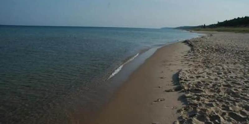
Lake Michigan Campground is perched on the shores of Lake Michigan, 15 miles south of Manistee. The area creates an incredible setting with a scenic overlook of the lake and a sandy swimming beach. This family campground provides an array of hiking and biking trails, plus swimming, fishing and kayaking.
Recreation
A hardwood forest gives way to a beautiful sandy beach at the shores of the lake with a playground for younger campers. Trout fishing in Lake Michigan is another big draw. Bird watchers delight in seeing unique species like the piping plover and prairie warbler. The Arrowhead Trail, a short loop trail created by Boy Scouts, forms a loop between the campground and the beach. A trailhead for the Nordhouse Dunes Wilderness Area is also within the recreation area.
Facilities
An amphitheater offers educational programs throughout the peak season. Other amenities include flush and vault toilets, beach access and an overlook deck. Campsites are equipped with picnic tables and pedestal grills. Group campsites can each accommodate a maximum of 50 guests.
Natural Features
The recreation area sits on the eastern banks of Lake Michigan along Porter Creek, due north of Hamlin Lake. As the second largest of the five Great Lakes, Lake Michigan provides stunning views and limitless options for water recreation. It covers a whopping 22,400 square miles and ranks as the fifth largest lake in the world. The Huron-Manistee National Forests encompass nearly a million acres of public protected land. Nearly 6,000 acres is wetlands that extend over the northern portion of Michigan's Lower Peninsula.
Nearby Attractions
The nearby Nordhouse Dunes Wilderness Area has abundant trails for hiking and backpacking.
Contact Info
For facility specific information, please call (801) 226-3564.
Fee Info
Fees for the Group Sites are as follows, $55/night for up to 25 occupants and $72/night for 26-50 occupants.
RV Road Trip Guides

Map & DirectionsLake Michigan Recreation Area is located in Michigan near Manistee
Directions
From the north, take US-31 south 10 miles from its junction with M-55 in Manistee, then right on Forest Trail Road (FS 5629) for 8 miles to the site. From the south, take US-31 north 11.5 miles from its junction with US-10 at Scottville, then left onto Forest Trail Road (FS 5629) for 8 miles the site.
Address
LOWER PENNISULA
MI
Coordinates
44.1191667 N
86.4275 W
Connectivity
 T-MobileLTESome CoverageVerified by 10 usersLast on 7/4/26
 VerizonNo CoverageVerified by 4 usersLast on 7/4/26
- AT&TNo CoverageVerified by 1 userLast on 7/4/26
Connectivity
- T-MobileLTESome CoverageVerified by 10 usersLast on 7/4/26
- VerizonNo CoverageVerified by 4 usersLast on 7/4/26
- AT&TNo CoverageVerified by 1 userLast on 7/4/26
Access
- Drive-InPark next to your site
- Walk-InPark in a lot, walk to your site.
- Boat-InSites accessible by watercraft.
Site Types
- Tent Sites
- RV Sites
- Standard (Tent/RV)
- Dispersed
- Group
- Tent Cabin
Features
For Campers
- Trash
- Picnic Table
- Firewood Available
- Reservable
- Drinking Water
- Toilets
- Alcohol
- Pets
- Fires
For Vehicles
- Big Rig Friendly
Contact
General Info
Reservations
Drive Time
- 1 hr 27 min from Muskegon, MI
- 1 hr 45 min from Traverse City, MI
- 3 hrs 37 min from Sheboygan, WI
- 3 hrs 50 min from Green Bay, WI