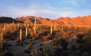
Dispersed camping in the Sonoran Desert near Ajo, Arizona provides access to primitive sites with varied terrain, typically requiring self-sufficiency. Located approximately 110 miles west of Tucson at an elevation of 1,750 feet, this region experiences mild winter temperatures in the 65-75°F range during peak camping season from November through March. Summer temperatures regularly exceed 100°F, making winter the primary camping season when the desert landscape supports more active wildlife.
What to do
Visit historic sites: The mining history around Ajo offers exploration opportunities. "We have never camped in the desert before, but it is still too cold for the woods. We enjoyed it and it really piqued our interest in desert camping. We did a short overland hike with no trail," noted a camper at Darby Wells Rd BLM Dispersed.
Explore Organ Pipe Cactus National Monument: Located approximately 13 miles from rustic camping options south of Ajo. "There are many hiking and biking opportunities available just a short drive away into the National Monument. The Visitor's Center is also worth a visit," shared a reviewer staying at Gunsight Wash BLM Dispersed camping area.
Search for desert wildlife: Early mornings and evenings offer the best wildlife viewing. "Yotes yipping at night, owls, wrens and a ton of wildlife. Maybe be careful of packrats and leave your hood propped up with a light," advised a visitor at Ajo BLM Dispersed.
What campers like
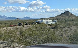
Spacious camping areas: The expansive BLM lands provide ample room between sites. "Plenty of space for dispersed, primitive camping. This seems like a popular place for primitive camping, but it is so easy to find a quiet private spot," reported one camper at Ajo BLM Dispersed.
Dark night skies: Winter visitors frequently mention exceptional stargazing opportunities at remote sites. "It was cloudy and a full moon but I could imagine the skies get super dark here," noted a camper at Gunsight Wash BLM Dispersed camping area.
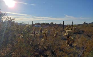
Desert landscape: The unique vegetation creates distinctive camping surroundings. "Great dispersed camping. The farther from the highway, the better it gets," shared a reviewer at Darby Wells Rd BLM. Another camper at Vekol Valley Road described "Tons of land to explore... Beautiful saguaro cactus and prickly pear, barrel, etc."
What you should know
Camping seasonality: The winter months provide the most comfortable temperatures for rustic camping near Ajo. "Tent campers having some trouble this time of year as the wind increases sharply in the afternoon," noted a February visitor at Ajo BLM Dispersed.
Limited supplies: Plan ahead for necessities. "The town of Why is within 2 miles of the Gunsight Wash turn off, which offers a gas station and convenience store. Further up the road lies Ajo, AZ, which has more in the way of restaurants and grocery stores," explained a reviewer.
Vehicle considerations: Many access roads require careful driving. "The access road is bumpy (unpaved road) but with any passenger car doable," stated a camper at Vekol Valley Road. Another camper noted: "Deep dip on Alley Rd coming in, about 1.8 miles from where the paved road ends, we scraped our bike hitch both coming and going."
Tips for camping with families
Bring entertainment: Limited developed recreation facilities means planning activities. "We enjoyed it and it really piqued our interest in desert camping. We did a short overland hike with no trail... We didn't see any hiking trails, so be careful you don't get lost," advised a family with three children (ages 6, 8, 11) camping at Darby Wells Rd BLM.
Safety awareness: Desert hazards require vigilance. "Watch out for the broken glass and old rusty metal," cautioned a camper at Darby Wells Rd BLM. Another mentioned, "Very quiet so much glass and old rusted tin cans, possibly from when mining was active here... There are open mine pits, some fenced off, some not so be careful especially if you let your pets run free."
Educational opportunities: Historical sites provide learning experiences. "The mine museum was still open and very interesting. It even interested the three kids (6, 8, 11 years old)," shared a family at Darby Wells Rd BLM Dispersed.
Tips from RVers
Site selection strategy: Larger rigs should scout carefully before committing. "Coming off of Alley Rd to pull out spots could be tricky for bigger rigs. There were a few nice looking spots that we didn't attempt in our 26ft Class C because the road up was too steep," advised an RVer.
Cell service considerations: Connectivity varies by location and carrier. "Good verizon 4bars on 4GLTE, ATT had 2-3 bars on 3G, very slow," reported an RVer at Ajo BLM. Another mentioned, "The further back you go, you will loose cell signal completely."
Leveling requirements: Prepare for variable terrain. "We chose to drive in about 5 miles and had no trouble finding a level spot," shared a visitor at BLM Sonoran Desert National Monument - Vekol Road Dispersed Camping Area. At Vekol Valley Road, a reviewer noted "Plenty of level places to park. We drive a van but I think most sizes of RV would have no trouble here."


 Scout
Scout