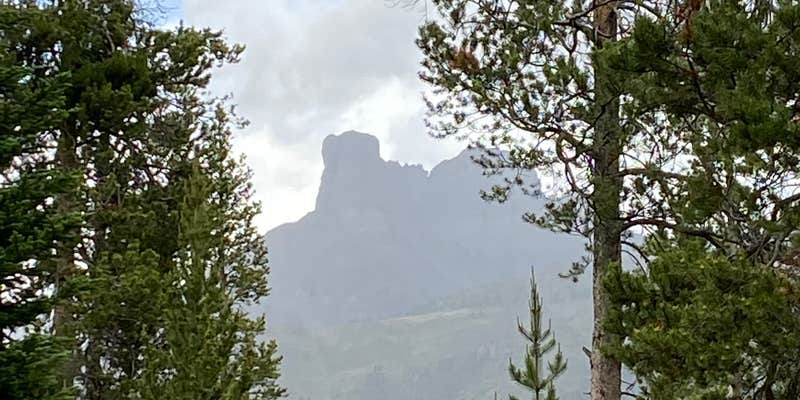

Within the Shoshone National Forest, Double Cabin Campground sits along the Wiggins Fork of the Wind River, accessed by a challenging 30-mile dirt road that winds through the mountains with steep drop-offs. The US Forest Service manages this forested site, which accommodates RVs up to 32 feet and provides standard amenities including drinking water, restrooms, and picnic tables from late May through early September.
The campground's proximity to the creek creates opportunities for brook trout and cutthroat fishing, while horse corrals serve equestrians exploring the backcountry trails. Campers frequently spot mule deer, and hunters report the area supports populations of elk, black bears, and moose. The winding access road sees regular horse trailer traffic, requiring patience and careful driving. Several dispersed camping areas extend beyond the formal campground boundaries for those seeking additional solitude.
Todd C. advises visitors to "plan on staying days to explore the creek bed" and recommends bringing bear spray. The camp host actively patrols both the campground and surrounding dispersed areas, providing guidance on fire safety and wildlife precautions. Water service has experienced interruptions in recent seasons, so confirming availability before arrival proves wise.
The remote location offers clear night skies and access to rockhounding opportunities along the creek drainage. Campers seeking similar mountain experiences can explore other places to camp around Shoshone National Forest throughout the region.
Description
This campground hosts 14 units on the border of the Washakie Wilderness. Two trails go north from this campground deep into the wilderness, and one trail leads south along the wilderness boundary. The Frontier Creek Trail leads to a petrified forest. It is illegal to remove petrified wood from this area. Water is available. Maximum spur is 32 feet. This site is not accessible for those with mobility impairments.
RV Road Trip Guides

Map & DirectionsDouble Cabin Campground is located in Wyoming near Dubois
Directions
From Dubois, take Forest Road 285 north for 28 miles.
Coordinates
43.80662343 N
109.56074697 W
Connectivity
 T-MobileNo Coverage
- VerizonNo Coverage
- AT&TNo Coverage
Connectivity
- T-MobileNo Coverage
- VerizonNo Coverage
- AT&TNo Coverage
Access
- Drive-InPark next to your site
- Walk-InPark in a lot, walk to your site.
Site Types
- Tent Sites
- RV Sites
- Standard (Tent/RV)
- Group
- Tent Cabin
- Equestrian
Features
For Campers
- Trash
- Picnic Table
- Firewood Available
- Drinking Water
- Toilets
- Alcohol
- Pets
- Fires
Drive Time
- 4 hrs 23 min from Idaho Falls, ID
- 5 hrs 6 min from Pocatello, ID
- 5 hrs 46 min from Billings, MT
- 6 hrs 38 min from Bozeman, MT


