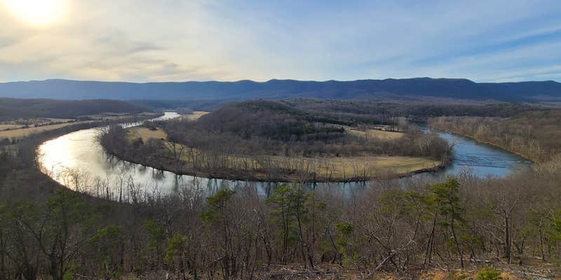
Paddlers and anglers find direct access to 5.2 miles of Shenandoah River shoreline at this 1,600-acre state park in northern Virginia. The campground offers multiple camping styles across its grounds, from RV sites with hookups to walk-in tent sites positioned along the riverbank.
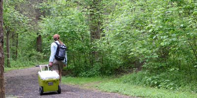
The primitive tent camping area draws visitors seeking river proximity without vehicle access. These 12 walk-in sites require campers to park in a designated lot and cart gear to their spots using provided wagons. Tara S. notes that "a few of the sites are right on the Shenandoah River, with incredible views," while sites set back from the water still maintain wooded privacy. Each site includes a fire pit, picnic table, and lantern pole on level gravel pads.
Hiking trails wind throughout the park's terrain, connecting to boat launches and offering varying difficulty levels. The clear river water supports fishing, canoeing, and kayaking, with class I and II rapids accessible through local outfitters. A visitor center provides park information, and rangers regularly patrol the grounds. Wildlife includes black bears, requiring proper food storage, plus copperheads and large but harmless bees that frequent the area.
The bathhouse serves primitive campers with private showers and clean facilities, though Leslie B. describes it as having "poor ventilation so it makes for a sauna when it's in the warm season." Cell service varies by carrier, with some visitors reporting no coverage. The park operates year-round with reservations available, and firewood sells for $6 per bundle on an honor system. Sites fill quickly during summer weekends, while weekday visits see lighter crowds.
Campers wanting full hookups can explore campgrounds around Bentonville or check Cornerstone just over a mile northeast for additional options.
Description
The park, including all of the overnight facilities, is open year-round. Lodging options include standard tent-only sites, electric-water camping, three yurts, four camping cabins (bunkhouses), regular cabins and a lodge.
Warning 5 Alerts are In Effect
There are 5 alerts for this campground. Camp safely!
Warning 5 Alerts are In Effect
There are 5 alerts for this campground. Camp safely!
Cancellations must be made by calling the Park or Customer Service Center by the day prior to your reservation. Cancellations can also be made online for most sites. If you choose to cancel your reservation, the reservation service fee will not be refunded and, once a reservation is paid for, a cancellation fee will be charged. Depending on the facility and/or the length of the advance notice, this fee may be a significant portion of the amount paid. Cancellation fees are as follows:
Standard campsites (up to 6 occupants): $10 per reservation, includes horse stalls.
Group campsites (sites that allow 7 or more occupants): $30 per reservation.
Camping Cabins: $10 if cancelled more than 30 days before the scheduled arrival, $10 per night within the last 30 days.
Yurts and Bunkhouses: $30 if cancelled more than 30 days before the scheduled arrival, $30 per night within the last month.
Cabins and Kiptopeke's EW Yurt: $30 if canceled more than 90 days before the scheduled arrival, $30 per night within the last 90 days.
Lodges: $60 if canceled more than 90 days before the scheduled arrival, $60 per night with the last 90 days.
Picnic Shelters: $10 up to 14 days prior to the start of the reservation, no refund within 14 days of the scheduled arrival.
Please verify cancellation fees for other facilities on our website before making your reservation. Once the official check-in time is reached or after a customer checks in (whichever comes first), any reduced stay constitutes an early departure. For camping there is a one night penalty for early departure. For cabin stays, there is a $30 per night penalty ($60 per lodge night) for early departure and the two night minimum is enforced regardless. Due to the week discount for cabins, reducing the stay down from a week will result in a higher nightly fee.
Transfers can be handled by the Customer Service Center or online (most sites). For cabins, lodges, yurts, camping cabins, and bunkhouses, transfers can be requested up until 4 days prior to your reservation start date. Camping transfers can be handled up until the day prior to check-in. Shelter transfers can be handled up until the day before your reservation, or the last day the Customer Service Center is open before your arrival. All transfers are free, but different seasons and sites may incur additional fees.
Our parks are strictly enforcing honor parking rules. To avoid any inconvenience, overnight guests who arrive when the contact station or office is closed are asked to register promptly the next day so park staff will not ticket your vehicle(s) in error. Campers and cabin guests are allowed two vehicles per site. Additional vehicles and visitors are subject to the daily parking fee. If you receive a parking ticket in error, please be sure to report the error to park staff immediately so the ticket can be canceled before it is processed.
Late Cabin Arrivals:
A sealed packet of information with your last name will be left for you. This packet will be at one of the following places: contact station, visitor center or park office. Claytor Lake and First Landing will leave your packet at the cabin. Your last 4 digits of your confirmation number will be your access code. Please take your confirmation letter with you.
Late Camping Arrivals:
A sealed packet of information with your name will be left for you. This packet will be at one of the following places: contact station, visitor center, park office or the campground camp host site. Please take your confirmation letter with you. If you have a site specific reservation please look for your site highlighted by the yellow post along with your site number. If you have a non-site specific reservation please look for your site type to set up your equipment.
Notice for Campers and Cabin Guests:
We're hiring! dcr.virginia.gov/jobs
Linens are not provided, so guests will need to bring their own sheets, pillowcases, blankets, towels, washcloths and dish towels.
Portable showers that do not drain to wastewater storage tanks are prohibited by state law. Collected wastewater must be disposed of properly.
There is a per night per pet fee for cats and dogs in all cabins and lodges (pets are not allowed in the yurts). Customers making reservations via the web are responsible for visiting the park office to pay all applicable pet fees. Customers may also call the reservation center at 800-933-7275 to pay the pet fees in advance.
Play it safe - Leave your firewood at home.
One of the most important things we can do to protect Virginia's trees and forest diversity is to stop moving firewood. New infestations of tree-killing insects and diseases are often first found in campgrounds and parks. Why? Because people have accidently spread invasive species when they brought firewood along with them. In Virginia, there are numerous counties under quarantines issued by the Virginia Department of Agriculture and Consumer Services due to an invasive insect pest or disease. These quarantines restrict the movement of firewood or wood by products from certain tree species. For more information on areas under quarantine, go to http://www.dcr.virginia.gov/state-parks/firewood-quarantine. Virginia State Parks recommends that you do not bring firewood from home but buy it at the park or in the parks locality. Any wood brought to the park should be fully burned before leaving.
Late Cabin/Lodge/Yurt/Camping Cabin/Bunkhouse Arrivals:
A sealed packet of information with your last name will be left for you. This packet will be at one of the following places: contact station, visitor center or park office. Claytor Lake and First Landing will leave your packet at the cabin. Your last 4 digits of your confirmation number will be your access code. Please take your confirmation letter with you.
Late Camping Arrivals:
A sealed packet of information with your name will be left for you. This packet will be at one of the following places: contact station, visitor center, park office or the campground camp host site. Please take your confirmation letter with you. If you have a site specific reservation please look for your site highlighted by the yellow post along with your site number. If you have a non-site specific reservation please look for your site type to set up your equipment.
The renter is responsible for any damages or excess cleaning created during their visit. The renter agrees to being charged the full cost to cover such damages and / or excess cleaning. A letter will be mailed giving details of the damages / cleaning and break down of the cost involved to rectify the problem. Should a credit card be on file, it will be charged. If not, an invoice will be included with the letter for immediate payment.
Guarded lake swimming is generally available at the designated swimming beach during scheduled hours between the Saturday of Memorial Day weekend and Labor Day. One day of swimming is free for each night reserved for overnight guests. During this time period the weather and other issues beyond our control may reduce the availability of guarded swimming. No refunds will be given if guarded swimming is not available. Outside of guarded swimming times, park guests may swim at the designated beach within marked areas. Swimmers using these areas do so at their own risk. Swimming anywhere else in the park at any time is prohibited.
Reservations only guarantee the facility or site being rented. Programs and park amenities may be cancelled or closed for various reasons and do not constitute a refund.
Pursuant to the Code of Virginia, all open fires (including wood and charcoal) are prohibited between February 15 and April 30 annually (except between the hours of 4PM to midnight). Camping stoves that are self-contained are permitted (ex. Coleman Stove). We have received permission from the Department of Forestry to allow open fires between midnight and 4 p.m. in our campgrounds if we have a camphost. Failure to observe the burning law could result in a fine of up to $500.00.
As part of your trip planning, before you arrive at the park, check out our events database to see the programs scheduled at your park. You can find the database here: http://bit.ly/vspevents. The events are sometimes added as late as the start of the month they will occur, so check back right before you leave. Another way to keep in touch with programs and offerings is to subscribe to our weekly enewsletter. It takes just a few minutes to sign up here: http://bit.ly/vspenews. You can also follow us on Facebook (www.facebook.com/virginiastateparks) and Twitter (@VAStateParks).
Campers cannot be assured of access to reserved sites before 4 p.m. on their arrival date, but early check-in is often available. Camping check-out is 1 p.m. Generators are not permitted in the campgrounds.
Cabin/Lodge/Camping Cabin/Camping Lodge/Trailer/Yurt check in time is 4:00 p.m. Check out is 10:00 a.m.
State law prohibits state employees from accepting gratuities. If you are so inclined, you may direct gifts or donations to: The State Park Projects Fund, c/o The Department of Conservation and Recreation, 600 E. Main St., 16th Floor; Richmond, VA 23219. These funds will be used for the development, maintenance, and operation of Virginia State Parks.
Customer satisfaction is a priority with State Parks and our Reservation Center. Please feel free to call the Operations Director, Nancy Heltman, with your compliments or concerns regarding your treatment by our staff. Nancy can be reached at 1-800-933-7275 (786-5057 if local Richmond). For changes to your reservation, please call 1-800-933-7275 9 a.m. to 5 p.m. Monday-Friday.
Please tell us what you think. Fill out our online survey for your chance to win a $50 gift certificate and other prizes in our monthly drawing. http://bit.ly/surveyvsp.
Virginia State Parks offer numerous opportunities for volunteers. If you are interested, please contact Email.
Yurt 1 and 2 are both located in the primitive campground. Sleeps three, but allows four. Each one is 500 feet from the bath house, 300 feet from the parking lot and 54 feet away from the vault toilets. Both have one queen bed and a twin sized trundle pull out. Guests must bring sleeping bags or linens. There is no smoking, cooking or pets allowed in the yurts. The yurts do not have electricity or water, but water is available at the bathhouse located about 500 feet away. There is no heat or air conditioning. Each yurt has a dining table, a large wooden deck with patio tables, a picnic table and fire ring with cooking grate. Parking for 2 vehicles is allowed, but any additional vehicles must pay a daily parking fee and park in the overflow lot by the Massanutten Shelter.
RV Road Trip Guides


Map & DirectionsAndy Guest/Shenandoah River State Park Campground is located in Virginia near Bentonville
Directions
The park is in Warren County, 8 miles south of Front Royal and 15 miles north of Luray. It's off Rt. 340 in Bentonville. Its address is 350 Daughter of Stars Drive, Bentonville, VA 22610; Latitude, 38.854777. Longitude, -78.306552. From Northern Virginia, take I-66 West to exit 13 (Linden). Turn left off the ramp. Go one block to a stoplight where you'll take a right onto Rt. 55 West. At the fifth stoplight, turn left onto 340 South. Drive eight miles; the park's entrance is on the right. From I-81 North, take exit 300 onto I-66 East. From I-66, take exit 6. Turn right off the ramp onto 340 South. Follow 340 South through Front Royal, then drive eight miles to the park's entrance on the right. From I-81 South, take exit 264 to New Market and Luray. Turn right off the ramp. Turn left at the second stoplight, go one block to another stoplight and turn right onto 211 East. Stay on this highway for 15 miles, where you'll take a right exit onto 340 North. Drive about 12 miles to the park's entrance on the left. Drive Times: Northern Virginia, one and a half hours; Richmond, two and a half hours; Tidewater/Virginia Beach, four and a half hours; Roanoke, two and a half hours
Address
350 Daughter Of Stars Dr
Bentonville, VA 22610
Coordinates
38.86294987602304 N
78.30237857682664 W
Connectivity
 T-Mobile5GExcellent CoverageVerified by 1 userLast on 6/28/26
 VerizonLTEGood CoverageVerified by 14 usersLast on 6/28/26
- AT&T5GExcellent CoverageVerified by 4 usersLast on 6/28/26
Connectivity
- T-Mobile5GExcellent CoverageVerified by 1 userLast on 6/28/26
- VerizonLTEGood CoverageVerified by 14 usersLast on 6/28/26
- AT&T5GExcellent CoverageVerified by 4 usersLast on 6/28/26
Access
- Walk-InPark in a lot, walk to your site.
- Hike-InBackcountry sites.
Site Types
- Tent Sites
- RV Sites
- Standard (Tent/RV)
- Group
- Cabins
- Tent Cabin
- Yurts
Features
For Campers
- Picnic Table
- Firewood Available
- Phone Service
- Reservable
- Alcohol
- Pets
- Fires
For Vehicles
- Big Rig Friendly
Contact
General Info
Reservations
Drive Time
- 32 min from Winchester, VA
- 51 min from Harrisonburg, VA
- 1 hr 8 min from Hagerstown, MD
- 1 hr 28 min from Charlottesville, VA


