Public Campground
Summit Ridge Lookout Cabin
Summit Ridge Lookout Cabin is located in the Black Hills National Forest, featuring forested terrain with rolling hills. The area experiences temperature highs around 80°F in summer and lows near 10°F in winter. Nearby attractions include Jewel Cave National Monument and Wind Cave National Park, offering opportunities for exploration and adventure.
Description
Overview
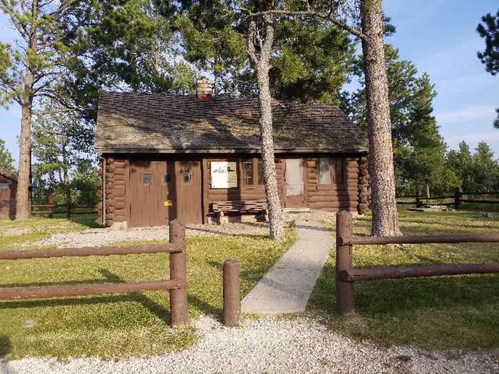
Summit Ridge Cabin is located near the border of Wyoming in Southwestern South Dakota on the Black Hills National Forest, providing a perfect setting for guests seeking recreation and relaxation. Built by the Civilian Conservation Corps in the 1930's, the cabin was originally used as housing for personnel that staffed the adjacent forest fire lookout tower. The cabin is available for reservation throughout the year when accessible. At an elevation of 6,096 feet, it can receive considerable snowfall. The roads to the cabin are not plowed, so generally it is not accessible from December through March. NOTE: Check with local office for snow conditions during winter months.
Recreation
The area around the cabin is remote, yet offers visitors a multitude of recreational opportunities throughout all seasons. Hiking, hunting, fishing, horseback riding, mountain biking, and riding off-highway vehicles are popular in summer and early autumn. Snowshoeing, skiing and snowmobiling offer visitors a chance to seek out winter landscapes. For hikers and bikers, the George S. Mickelson Trail, near Custer, South Dakota (approximately 40 miles from the cabin) traverses over 100 miles through the heart of the Black Hills, with four tunnels, more than 100 converted railroad bridges, and 15 established trailheads spaced along the route. The trail surface is packed gravel, traversing mountain, meadow, and forest terrain.
Facilities
The cabin measures 22' x 32' and is comfortable for four people, though groups as large as ten may reserve the facility. The cabin is furnished with three bunk beds. Bedding and mattresses are not provided. The cabin is equipped with a propane stove for cooking, a wood stove for heat and an outdoor fire ring. Guests must provide the propane. Visitors must also bring several of their own supplies as the cabin does not have food, cooking utensils, sleeping bags, sleeping pads, towels, dish soap, matches, pots and pans, toilet paper or garbage bags. Guests must also bring their own firewood and water for cooking, washing and drinking. There is no drinking water available at this site. Although solar LED lighting is available, an additional light source is recommended. Kerosene lamps are not permitted for fire safety reasons. An accessible vault toilet is located on site and a steel firetower is located near the cabin, but is closed for public use. Summit Ridge Lookout Cabin also has 2 RV sites at additional $12 each, allowing RVs up to 20 and 30 feet. If you would like to use these RV sites, please enter 11 people, and if you would like both please enter 15 people. The RV sites are not reservable on their own but in addition to the rental of the cabin.
Natural Features
Located in western South Dakota and northeastern Wyoming, Black Hills National Forest encompasses nearly 1.25 million acres of rugged rock formations, canyons and gulches, open grassland parks, tumbling streams, deep blue lakes, and unique caves. Derived from the Lakota language, the words "Paha Sapa," meaning "hills that are black," honor the dark, pine-covered hills rising several thousand feet above the surrounding prairie. Situated in a grassy understory beneath Ponderosa pine, the area around Summit Lookout Cabin exemplifies this landscape. Wildlife in the area abounds. Bighorn sheep navigate mountainous terrain, while elk, deer and pronghorn gather in forests and prairies. Bald eagles, hawks, osprey, peregrine falcon, and hundreds of other bird species can be found in the forest, especially along streams, lakes and rivers.
Nearby Attractions
Explore Mount Rushmore National Memorial, host to almost 3 million visitors a year from across the country and around the world. Managed by the National Park Service, visitors will have the opportunity to learn about the birth, growth, development and the preservation of the United States, and take in the beauty of South Dakota's Black Hills. South Dakota caves are some of the most unique in the United States. Boasting sparkling calcite crystals and other rare formations, as well as some of the largest concentrations of passageways in the world, nearby Jewel Cave is currently the second longest in the world, at 180 miles. Other possible day trips include Custer State Park, Crazy Horse Monument and Wind Cave National Park.
Location
Summit Ridge Lookout Cabin is located in South Dakota
Directions
Entrance into the cabin is by combination lock. Prior to your arrival please contact the Hell Canyon Ranger District, Monday - Friday between 8:00 AM to 4:30 PM Mountain Time, at 605-673-9200 to obtain the combination. From Newcastle, Wyoming, travel east on US Highway 16 for approximately 9 miles to Forest Service Road 117, Boles Canyon Road. Go North on Boles Canyon Road for approximately 12 miles and turn left on Forest Service Road 265, Summit Road. Follow Summit Road for approximately three miles to the Summit Ridge Cabin which is on the left. Note that Boles Canyon Road and Summit Road do not receive any maintenance during winter months, including snow plowing.
Address
Hell Canyon Ranger District, 1019 North 5th Street
Custer, SD 57730
Coordinates
43.8541667 N
104.0525 W
Connectivity
- T-MobileNo Coverage
- VerizonLTESome Coverage
- AT&T5GExcellent Coverage
Connectivity
- T-MobileNo Coverage
- VerizonLTESome Coverage
- AT&T5GExcellent Coverage
Access
- Drive-InPark next to your site
Site Types
- Cabins
Features
For Campers
- Reservable
Drive Time
- 1 hr 51 min from Rapid City, SD
- 3 hrs 9 min from Casper, WY
- 4 hrs 1 min from Cheyenne, WY
- 4 hrs 37 min from Fort Collins, CO


