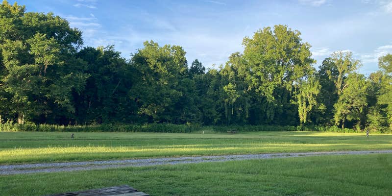
Gunfire from the adjacent shooting range punctuates mornings at this Fish and Wildlife Service campground, with activity typically running from 8am to 7pm daily. Located three miles down a well-maintained gravel road in Sherburne Wildlife Management Area, the site provides free camping along the Atchafalaya River with vault toilets and picnic tables at each spot.
Most campsites back directly to the water, offering fishing access and boat launch proximity. Alligators frequent the waterway, making swimming inadvisable according to multiple camper reports. The area maintains decent cell service despite its remote setting. "Nighttime is perfect though," notes Joshua H., referencing the quiet that settles after shooting range hours end.
Mosquitoes present a significant challenge year-round, with campers consistently recommending heavy-duty bug spray and enclosed cooking areas. The campground rarely fills to capacity, though weekend shooting enthusiasts and anglers create moderate daytime activity. Armadillos commonly visit campsites after dark. Well water is available at the ranger station for refilling tanks.
For a different experience, Three Mile Lake RV site offers hookups and quieter surroundings eight miles west.
Description
Sherburne WMA is located in the Morganza Floodway system of the Atchafalaya Basin between the Atchafalaya River and the East Protection Guide Levee. LDWF owns Sherburne WMA (11,800 acres) but manages the area as one unit along with the U.S. Fish and Wildlife Service’s Atchafalaya National Wildlife Refuge (15,220 acres) and another 16,618 acres owned by the U.S. Army Corps of Engineers. Map: https://www.wlf.louisiana.gov/assets/Conservation/WMAs_Refuges_Conservation_Areas/Files/Sherburne.pdf The area is classified as bottomland hardwoods with four dominant tree species groups: cottonwood-sycamore, oak-gum-hackberry-ash, willow-cypress-ash, and overcup oak-bitter pecan. Midstory species include seedlings of dominant species along with boxelder, maple, red mulberry, and rough-leaf dogwood. LDWF has managed the timber in some areas to improve habitat; ground cover in these areas is very dense and provides excellent habitat for many game and non-game species. Common ground cover species include rattan, greenbrier, Rubus sp., trumpet creeper, Virginia creeper, poison ivy, elderberry, and milkweed.
Map & DirectionsSherburne WMA is located in Louisiana near Breaux Bridge
Directions
You can access Sherburne WMA via Hwy 975, which connects with Hwy 190 east of Krotz Springs on the north and I-10 at Whiskey Bay on the south. Access routes to the interior include a series of all-weather roads, ATV trails, and Big and Little Alabama Bayous. There are two public boat launches on Big Alabama Bayou. There is one public launch on the northern portion of Little Alabama Bayou.
Coordinates
30.51536437 N
91.7139244 W
Connectivity
 T-Mobile5GGood Coverage
 VerizonLTESome CoverageVerified by 4 usersLast on 7/31/26
- AT&T5GGood CoverageVerified by 6 usersLast on 7/31/26
Connectivity
- T-Mobile5GGood Coverage
- VerizonLTESome CoverageVerified by 4 usersLast on 7/31/26
- AT&T5GGood CoverageVerified by 6 usersLast on 7/31/26
Access
- Drive-InPark next to your site
- Walk-InPark in a lot, walk to your site.
- Boat-InSites accessible by watercraft.
Site Types
- Tent Sites
- RV Sites
- Standard (Tent/RV)
- Group
Features
For Campers
- ADA Access
- Trash
- Picnic Table
- Firewood Available
- Phone Service
- Toilets
- Alcohol
- Pets
- Fires
For Vehicles
- Big Rig Friendly
FREE established camping
Enjoy camping on government land. Limited or no services at this camping area.
PERMIT might be REQUIRED
We curate permit requirements across the US for our PRO members. Try PRO to see if Sherburne WMA needs a permit.
Drive Time
- 47 min from Baton Rouge, LA
- 49 min from Lafayette, LA
- 1 hr 19 min from Alexandria, LA
- 1 hr 19 min from Hammond, LA


