

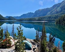
Ice Cave Boondock - Dispersed BLM Camping is located near the rugged terrain of Idaho. Temperatures in this area can range from lows in the 20s Fahrenheit during winter to highs in the 80s during summer. Nearby attractions include the Shoshone Ice Caves and Craters of the Moon National Monument, offering unique geological features for exploration.
Description
Camping on public lands away from developed recreation facilities is referred to as dispersed camping. Most of the remainder of public lands are open to dispersed camping, as long as it does not conflict with other authorized uses or in areas posted "closed to camping," or in some way adversely affects wildlife species or natural resources.
Dispersed camp sites are located along most secondary roads and may not be marked. Popular locations can be recognized by the telltale flat disturbed area that has been used as a camp site before. Not all flat spots are sites. If possible, please use existing sites to avoid creating new disturbances. To further protect your public lands, campers must not dispose of any refuse, hazardous materials, sewage, or in any manner pollute the surrounding area.
Dispersed camping is allowed on public land for a period not to exceed 14 days within a 28 consecutive day period. The 28 day period begins when a camper initially occupies a specific location on public lands. The 14 day limit may be reached either through a number of separate visits or through 14 days of continuous overnight occupation during the 28 day period. After the 14th day of occupation, the camper must move outside of a 25 mile radius of the previous location until the 29th day since the initial occupation. The purpose of this special rule is to prevent damage to sensitive resources caused by continual use of any particular areas. In addition, campers must not leave any personal property unattended for more than 10 days.
RV Road Trip Guides

Map & DirectionsIce Cave Boondock is located in Idaho near Richfield
Coordinates
43.16640186 N
114.32137397 W
Connectivity
 T-Mobile5GGood CoverageVerified by 2 usersLast on 4/21/26
 VerizonLTESome CoverageVerified by 4 usersLast on 7/24/26
 AT&T5GExcellent Coverage
Connectivity
- T-Mobile5GGood CoverageVerified by 2 usersLast on 4/21/26
- VerizonLTESome CoverageVerified by 4 usersLast on 7/24/26
- AT&T5GExcellent Coverage
Access
- Drive-InPark next to your site
- Walk-InPark in a lot, walk to your site.
Site Types
- Dispersed
Features
For Campers
- Market
- Alcohol
- Pets
DISPERSED CAMPING
Enjoy dispersed camping on government land and leave no trace. Pack in and pack out. No (or limited) services at this camping area. Permit may be required.
PERMIT might be REQUIRED
We curate permit requirements across the US for our PRO members. Try PRO to see if Ice Cave Boondock - Dispersed BLM Camping needs a permit.
Drive Time
- 45 min from Twin Falls, ID
- 1 hr 52 min from Boise, ID
- 2 hrs 5 min from Pocatello, ID
- 2 hrs 9 min from Idaho Falls, ID


