Best Dispersed Camping near Suches, GA

Dispersed camping in the Suches, Georgia area offers several free primitive sites within the Chattahoochee National Forest. Popular locations include Preacher's Rock, Justus Creek Campsite, and Dicks Creek Falls Campsites. These sites provide basic backcountry camping with varying levels of accessibility. Most sites feature established fire rings but lack amenities such as drinking water, toilets, or trash service. According to reviews, Dicks Creek Falls has "only 5 or 6 spots available for first come first serve camping" with some sites positioned closer to water while others are more remote.

Access to most sites requires travel on unpaved forest service roads. A vehicle with moderate clearance is recommended, particularly after rain when roads may become rutted or slippery. Several campers noted that GPS coordinates can be unreliable in the area, so having offline maps is advisable. Cell service is typically limited or non-existent throughout the region. The Jones Creek Dispersed Campground offers riverside camping but can be "popular for local dirt bikers" according to visitor reports.

This region is designated bear country, requiring proper food storage and waste management. All sites operate on a strict pack-it-in, pack-it-out basis. Fires are permitted at most locations when no fire bans are in effect, but visitors must bring their own firewood or collect dead and downed wood responsibly. The best sites fill quickly during summer weekends and fall color season. Winter camping is possible but prepare for cold temperatures and potential road closures at higher elevations. Camping is limited to 14 consecutive days in any 30-day period per Forest Service regulations.

Best Dispersed Sites Near Suches, Georgia (59)

Show More
Showing results 1-10 of 59 campgrounds

2025 Detourist Giveaway

Presented byToyota Trucks

Review Campgrounds. Win Prizes.

Enter to Win


Dispersed Camping Reviews near Suches, GA

105 Reviews of 59 Suches Campgrounds


  • Steve V.The Dyrt PRO User
    Jun. 1, 2022

    Big Creek Primitive Camping Area

    Remote Primitive Camping

    This is a great off grid camping spot along a creek. There are about 7 spots here with most of them each able to hold multiple vehicles and set ups. We had 3 vehicles (two with rooftop tents and one with a small teardrop trailer) and we still had room for more set ups in the spot we set up in. All the sites have at least 1 fire ring, most had multiple.

    This is primitive camping, so there are no facilities (no bathhouse, no power, no dump station, no trash, ect). It's all pack it in, pack it out. We had no service with Verizon. 

    This is also bear country, so you need to practice bear safety with your food and trash. We did not see any bears in camp, but did spot one just down the road the morning we were leaving. 

    There is hiking in the area and there are areas in the creek deep enough for wading and soaking. 

    This is along Forest Service Road 221 which this section of FS 221 shares driving trails such as the Big Frog Loop, the Georgia Traverse, and the Trans America Trail (TAT), so there could be lots of traffic with overlanders, adventure bikers, and off-roaders.

  • Kaylee D.
    Apr. 4, 2021

    Long Hungry Road Dispersed Campsites

    Absolutely gorgeous!

    Wow! Amazing primitive campsites! Each has a picnic table, fire pit/grill, and level area for 1-2 tents (a few can accommodate more if you’re ambitious), and lake views (most have lake access if you want to put in a kayak or canoe). Sites are so spread out it feels like you’re the only one on the lake! Most parking next to campsites could fit camper van or tiny trailer and at the end of the road there is a turn around space if needed; however every site has steps down to the level area (L9 has the longest straight down hill to the lake), so you won’t be parking right next to the site if that is a problem...it wasn’t for me). Just drive carefully( lots of big potholes and blind curves)! Overall, a beautiful area to set up camp (up to 14 days)! I didn’t want to leave.

  • BThe Dyrt PRO User
    Jun. 13, 2024

    Creekside Camp

    Very primitive

    No picnic tables or pit toilets. Flat campsites next to a very nice creek.

  • Natalie R.The Dyrt PRO User
    Feb. 9, 2024

    Lake Santeelah Dispersed

    Quiet, nice spaces, and clean!

    Such a great find! I was hoping to car camp a little closer to NOC but not in a campground but this is the closest I could find in February. I would definitely stay here again! Very quiet and clean and the sites are very well laid out and maintained! No hook ups of any kind but it’s worth it! Highway Patrol and Park Rangers patrol pretty frequently so I felt really safe as a solo female. I still took all the safety precautions but didn’t feel as necessary as some.

  • Myron C.The Dyrt PRO User
    Apr. 27, 2021

    Siler Bald Trail Shelter TR 373

    Trail Shelter along the Appalachian Trail

    Siler Bald is not to be confused with Silers Bald, which borders the NC/TN state line in the Great Smoky Mountains National Park. Siler Bald is actually in the Nantahala National Forest and is close to Wayah Bald along the Appalachian Trail. The shelter is aptly named after the adjacent mountain bald. I first went to Siler Bald many years ago but did not go to the trail shelter. This second time, I did go to the trail shelter, which is about nine-tenths of a mile past the Siler Bald summit if you are hiking north on the Appalachian Trail. If you are hiking from Wayah Bald, it is a little over three and a half miles. Since this is a trail shelter, it does not have electrical hookups. You will need to take a water filtration system for fresh water. Instead of searching for firewood, we used my old Coleman stove for dinner. Surprisingly, there were no other groups in the shelter the night we stayed there. The best things about this trail shelter are its proximity to the Appalachian Trail, the quietness you’ll experience since it is away from major highways, and its proximity to the Siler Bald summit. The summit provides a fantastic 360 degree view since it is a grassy bald, but it is a steep climb from the base to the summit. This is not an RV campground, and you do have to pack everything in(and out). You cannot go to the store to get supplies without hiking a long way, so be prepared. Overall, I loved it because of its peace and solitude.

  • Roy B.
    Nov. 6, 2021

    Ball Field Dispersed Camping Area

    Grassy Field in forested mountainous area.

    This is a primitive group camping area close to Lake Conasauga. GPS is 34.86064073010609,-84.63659794105651. (Photos and this review are from my last stay here on 31 Oct- 02 Nov 2021.) 

    The camping field is at the base of Bald Mountain, altitude 4005'. Nearby Tearbritches Trail will take you to the summit of Bald Mountain and then down to the Conasauga River. The Emery Creek Trail is at the back of the camping area. There are some fire pits in the open field. 

    The cell connection is intermittent and usually only one bar(or no cell). 

    This area is fairly remote and the rough gravel forest service roads are best traveled by a higher clearance vehicle. 2x2 usually works ok though. (It takes patience and a while to get here.) This is a popular mountain bike area and the cyclists can easily hit speeds of 30MPH on the sketchy downhills.

  • MThe Dyrt PRO User
    May. 16, 2022

    Long Hungry Road Dispersed Campsites

    Great peaceful spot

    The only downside to this campground is that for half of the sites the parking is across the small access road. This would be most ideal for tent camping.

  • William S.
    Sep. 25, 2021

    Albert Mountain Firetower Dispersed Campsite

    This one's for the hikers

    You can access this campsite by various means, but do your research and save yourself as many steps, because make no mistake, this is a serious hiking trail (a mile to a mile and a half, depending on route) up to the Fire Tower. 

    Part of the Appalachian Train, once you park your car or hike in, you'll make your way uphill over crude-cut rocks, tree roots, and muddy, narrow paths. Hiking poles are strongly recommended. The path down is just as treacherous as the path up, as moisture from the mountain drips down over craggy footholds. 

    While the path is popular with hikers, anyone camping should consider using a very small pack, especially since some of the trails have nothing but a chasm on one side. 

    Once you make it to the Fire Tower, however, all is forgiven. The site from the bottom is breathtaking, and you can see, well, forever. Heading up the tower (the very top is closed to visitors and mothballed), you get an almost full 360º panorama of the surrounding valleys and mountains. 

    The camp site itself is very rustic, no amenities other than a rock fire ring, and does not face the vistas. There's a weak LTE signal at the top, but be prepared to lose your signal along the way.

    Side note: I came through the Coweeta Hydrological Laboratory, which has numerous signs posted that you cannot camp there. However, it's part of the larger National Forest and it's not exactly clear where camping begins to be allowed, as there were several rustic sites along the trail at the upper end.

    If you do come driving through the Coweeta Hydrological Laboratory path, be prepared for narrow, steep gravel lanes. And keep in mind that if you do park your car on one of the (few) spaces available, you're going to be very far from it, and the site didn't appear to be patrolled in any way.

  • Steve V.The Dyrt PRO User
    Apr. 19, 2022

    Ball Field Dispersed Camping Area

    Large Dispersed Camping Field

    This is a large field for dispersed camping along Conasauga Lake Road that is popular with both hikers (Emery Creek Trail and Tear Britches Trail both have trailheads here) and Overlanders (site is on the Big Frog Loop and Georgia Traverse). There are multiple fire rings established around the field and this field can handle many groups. No water or facilities here, but you can go down to the Lake Conasauga Campground about a mile away and use their facilities for a $5 fee. The field is fairly sloped, so you want to have some shoring if you are in a trailer, roof top tent, or van.


Guide to Suches

Dispersed camping opportunities near Suches, Georgia extend throughout the Chattahoochee National Forest at elevations ranging from 2,100 to 4,700 feet. The surrounding Blue Ridge Mountains create varied camping terrain with numerous creeks and waterfall access points. Temperatures in this region typically drop 10-15 degrees compared to nearby lowland areas, with overnight lows frequently in the 40s even during summer months.

What to do

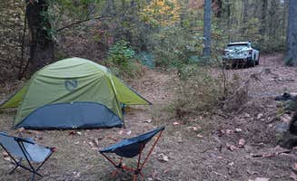
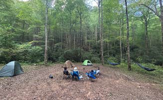
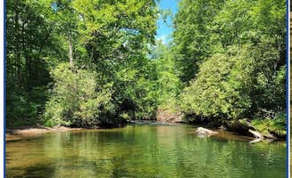
Waterfall swimming: At High Shoals Falls Trail Dispersed camping area, hikers can access two major waterfalls along a 2.4-mile round-trip trail. According to visitor Damion V., "The cool waters of High Shoals Creek offer rewarding refreshment after a day of exploring the various wildflowers and plant life while serving as a soothing sound to fall asleep too while stargazing."

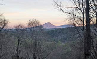
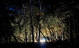
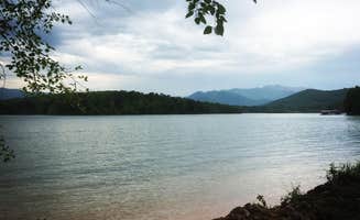
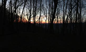
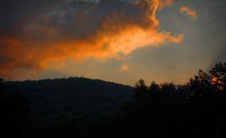
Stargazing opportunities: The Tray Mountain area provides exceptional dark sky viewing conditions. Camper Austin C. notes that Corbin Creek Tray Mountain "sits within the few dark areas within north Georgia," making it "worth it if you're into astrophotography."

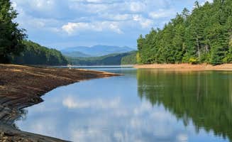
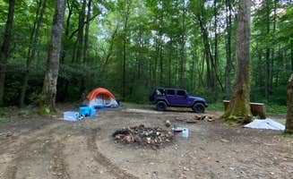
Creek exploration: Multiple campsites offer direct water access for cooling off during hot weather. At Jones Creek Dispersed Campground, Billie P. shares that "This river is amazing, low current makes its easy to walk in and there are a few little water falls we enjoyed hanging on for a bit."

What campers like

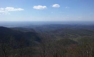
Mountain-top camping: Several sites provide ridge or summit camping with expansive views. Clay A. describes Cowrock Mountain as offering "wonderfully shaded spots with long range views of the Blue Ridge. Perfect spot for hammocks or tents right off the trail with large rocky outcrops for your views."

Multiple routes for adventure vehicles: The forest roads create various access options for those exploring by adventure motorcycle or 4x4 vehicle. Darwin R. recommends Indian Grave Gap Campsite: "If you're anywhere near Helen, GA on an ADV Bike, this summit is for you. There are three routes up the mountain so you never have to double back."

International appeal: The region attracts campers from various backgrounds. At Preacher's Rock, Ernesto H. reports "Hay como 3 sitios para casas de campaña pequeñas. Es en la cima de una montaña, la subida son unos 40 minutos, al final se vuelve más exigente si lleva mochila grande."

What you should know

Water source distances: Most free camping near Suches requires planning for water. At Cowrock Mountain, Clay A. advises "There is a water source about .5 miles west on the AT at Baggs Creek Gap or ~1.5 miles east at Hogpen Gap."

Vehicle requirements: Many dispersed sites require appropriate vehicles. Rebecca M. states that Corbin Creek Tray Mountain is "more Jeep friendly than full size vehicles, to get a spot down by the creek. But it is possible to get a full size 4*4 truck down the switch back."

Site availability timing: Competition for prime sites can be fierce during peak periods. Maria A. from Justus Creek Campsite reports that after "one of my favorite stretches of hiking we got to this campsite along the AT," suggesting arriving early during thru-hiking season.

Weather preparation: Temperatures fluctuate significantly in the mountains. Austin C. found that at Corbin Creek, "Weather got a little cooler at night but the stars were a beauty to see."

Tips for camping with families

Campsite selection for groups: Some areas accommodate larger family groups better than others. Gillian S. notes that Indian Grave Gap Campsite has "Three campsites in the immediate area. Two are on one side of the road. You have to cross thru one to get to the other. All three have creek access... Each site is huge."

Swimming hole access: For families with children, swimming holes provide recreational opportunities. Damion V. mentions High Shoals Falls Trail offers "rewarding refreshment after a day of exploring" with its creek access points.

Bear safety education: The area requires proper bear awareness. Maria A. shares at Justus Creek Campsite, "We were warned about bears in the area so were very cautious about hanging our bear bag a little extra distance away on the opposite side of the creek."

Supply planning: Limited nearby services require advance planning. Gillian S. reports, "The closest town is Hiawasee. Had a grocery and an outfitters if you need supplies. There's only two sit down restaurants—one had an hour wait; the other had run out of food."

Tips from RVers

Ground clearance requirements: RVers should assess forest road conditions carefully. The Mountainsiders note that at Mountain Side Overlook, "4x4 is not required, but ground clearance makes it non-accessible to some."

Site dimensions and accessibility: Many free camping areas near Suches have limited space for larger rigs. Darwin R. mentions Indian Grave Gap Campsite has "one site that would support a large group or even a camper (or two) if you can get them up the steep rocky hunting trail."

Campsite setup logistics: For RVers who find accessible sites, careful positioning is crucial. Wanderer describes Corbin Creek Tray Mountain as "Hike in style camp with the convenience of having your vehicle. A 4wd with moderate clearance is helpful."

Frequently Asked Questions

Where can I find dispersed camping in Suches, Georgia?

Suches offers excellent dispersed camping opportunities in the surrounding Chattahoochee National Forest. Preacher's Rock provides drive-in and hike-in free camping with beautiful mountain views. For a more secluded experience, Indian Grave Gap Campsite offers drive-in and walk-in options. Other nearby options include Justus Creek Campsite along the Appalachian Trail and Hightower Gap Camp. Remember that dispersed camping in this area typically requires following Leave No Trace principles and camping at least 150-200 feet from water sources, trails, and developed recreation areas.

What's the best time of year for dispersed camping in Suches, GA?

The prime seasons for dispersed camping in Suches are late spring (May-June) and early fall (September-October) when temperatures are moderate and conditions optimal. Jones Creek Dispersed Campground is particularly beautiful in fall with vibrant foliage. Summer (July-August) can be pleasant but expect afternoon thunderstorms and higher humidity. Mountain Side Overlook offers excellent views year-round, though winter camping requires proper cold-weather gear as temperatures regularly drop below freezing. Always check road conditions after heavy rain or winter weather, as forest service roads can become difficult to navigate.

What amenities are available at dispersed camping sites around Suches?

Dispersed camping sites around Suches are primitive with minimal to no amenities. Unicoi Gap Dispersed and most other sites have no potable water, electricity, or bathroom facilities. Some sites like Helton Creek Falls Camp may have established fire rings and flat tent spaces, but you'll need to pack in all supplies and pack out all trash. Cell service is generally spotty throughout the area. Always bring sufficient water or water purification methods, as most sites are near creeks but require treatment. For bathroom needs, follow Leave No Trace principles by digging a 6-8 inch cathole at least 200 feet from water sources.

Is dispersed camping allowed in Chattahoochee National Forest near Suches?

Yes, dispersed camping is allowed in Chattahoochee National Forest surrounding Suches. The forest follows standard USFS dispersed camping regulations - camp at least 150 feet from water sources, roads, and trails. Ball Field Dispersed Camping Area is a popular option with established fire rings and proximity to hiking trails like Emery Creek and Tear Britches. Dicks Creek Falls Campsites offer another excellent choice. Most areas allow up to 14 consecutive days of camping. No permits are required, but always check for seasonal fire restrictions or temporary closures before your trip.