Best Dispersed Camping near McCaysville, GA

Dispersed camping near McCaysville, Georgia is available in several areas within the Cherokee National Forest and Cohutta Wilderness. Free primitive sites can be found along creeks and forest service roads in both Tennessee and Georgia portions of the national forest. Areas such as Lost Creek, Goforth Creek, and the Jack's River Falls Trail provide opportunities for backcountry camping without developed amenities. These public lands permit camping in designated dispersed areas that require no reservations and have no fees.

Access to many dispersed sites requires travel on gravel forest roads, with some locations needing high-clearance vehicles or hiking to reach. The Goforth Creek area features multiple hike-in sites along a trail, while Lost Creek Campground is accessible via a 7-mile gravel road. Most dispersed camping areas lack drinking water, restrooms, and trash service, requiring campers to pack out all waste. Bear-proof containers are essential in this region, and proper food storage is necessary as bears have been spotted near camping areas. Camping duration is typically limited to 14 days in any 30-day period on national forest land.

These primitive camping locations primarily offer creek-side camping with natural swimming holes and fishing opportunities. The Cohutta Wilderness provides more remote experiences with backcountry trails leading to secluded camping spots. Reviews indicate the areas become crowded during weekends and peak seasons but remain relatively quiet during weekdays. The natural water features are highlights for many campers. "Super quiet when we were there in March. Toilet could be cleaner but at least it's there. Nice creek view through the side of the campground, likely no cell service unless you go one way or another up the mountain," noted one visitor to Lost Creek. Another camper at Big Creek Primitive Area shared: "This is a great off grid camping spot along a creek. There are about 7 spots here with most of them each able to hold multiple vehicles and set ups."

Best Dispersed Sites Near McCaysville, Georgia (52)

    1. Lost Creek - Cherokee NF

    9 Reviews
    Reliance, TN
    14 miles
    Website

    "The lost cove campground can be found deep in the wilderness of the Cherokee National Forest outside of Benton, TN. The campground is operated and maintained by the USFS."

    "We chose a spot next to the creek. Was clear and flowing due to a lot of rain the few days before we arrived. Sites had concrete picnic tables and a pad. We had to clean ours when we arrived."

    2. Jack's River Falls Trail/Cohutta Wilderness Backcountry Group Camp

    4 Reviews
    Cisco, GA
    12 miles

    "This is a tough trail but good for teens looking to challenge themselves in the back country. The views are amazing with rock falls. Camping is primitive as back country can be but worth the trek."

    "Obviously very close to the river to filter water from. We didn't see any wildlife at this site, but we did see a copperhead at another earlier in the trip, so be aware!"

    3. Rough Creek Dispersed

    1 Review
    Copperhill, TN
    8 miles

    "Only 2 sites and one intense drive to get here. It takes about 35 minutes to go 4 miles. Ground clearance and off road tires needed"

    4. Goforth Creek Campground A

    2 Reviews
    Reliance, TN
    11 miles
    Website

    "This campsite is a backcountry site located along the Goforth Creek trail and is the closest to the parking area. It is also the largest of the sites with room for several tents."

    5. Little Gassaway Creek

    1 Review
    Copperhill, TN
    9 miles

    "Only one campsite and requires either off-road tires or 4 x 4"

    6. Creekside Camp

    1 Review
    Reliance, TN
    11 miles

    "No picnic tables or pit toilets. Flat campsites next to a very nice creek."

    7. Big Creek Primitive Camping Area

    1 Review
    Reliance, TN
    11 miles
    Website
    +1 (423) 338-3300

    "This is a great off grid camping spot along a creek. There are about 7 spots here with most of them each able to hold multiple vehicles and set ups."

    8. Goforth Creek Campground B

    1 Review
    Reliance, TN
    11 miles
    Website

    "This is another large campsite that sits further up the creek and is pretty easy to find from the main trail. It is more open than site A but also a good option."

    9. Ball Field Dispersed Camping Area

    5 Reviews
    Crandall, GA
    18 miles
    Website

    "This is a primitive group camping area close to Lake Conasauga. GPS is 34.86064073010609,-84.63659794105651. (Photos and this review are from my last stay here on 31 Oct- 02 Nov 2021.) "

    "This is a large field for dispersed camping along Conasauga Lake Road that is popular with both hikers (Emery Creek Trail and Tear Britches Trail both have trailheads here) and Overlanders (site is on"

    10. Conasauga River Camp

    2 Reviews
    Cisco, GA
    15 miles

    "Lovely little spot next to a very swimmable and warm crystal clear river - very popular with locals, and I imagine would be packed on weekends."

    "My go-to spot gets picked up during the fall A lot but best dispersed site I’ve found in a while"

Show More
Showing results 1-10 of 52 campgrounds

2025 Detourist Giveaway

Presented byToyota Trucks

Review Campgrounds. Win Prizes.

Enter to Win


Dispersed Camping Reviews near McCaysville, GA

94 Reviews of 52 McCaysville Campgrounds


  • Steve V.The Dyrt PRO User
    Jun. 1, 2022

    Big Creek Primitive Camping Area

    Remote Primitive Camping

    This is a great off grid camping spot along a creek. There are about 7 spots here with most of them each able to hold multiple vehicles and set ups. We had 3 vehicles (two with rooftop tents and one with a small teardrop trailer) and we still had room for more set ups in the spot we set up in. All the sites have at least 1 fire ring, most had multiple.

    This is primitive camping, so there are no facilities (no bathhouse, no power, no dump station, no trash, ect). It's all pack it in, pack it out. We had no service with Verizon. 

    This is also bear country, so you need to practice bear safety with your food and trash. We did not see any bears in camp, but did spot one just down the road the morning we were leaving. 

    There is hiking in the area and there are areas in the creek deep enough for wading and soaking. 

    This is along Forest Service Road 221 which this section of FS 221 shares driving trails such as the Big Frog Loop, the Georgia Traverse, and the Trans America Trail (TAT), so there could be lots of traffic with overlanders, adventure bikers, and off-roaders.

  • Kaylee D.
    Apr. 4, 2021

    Long Hungry Road Dispersed Campsites

    Absolutely gorgeous!

    Wow! Amazing primitive campsites! Each has a picnic table, fire pit/grill, and level area for 1-2 tents (a few can accommodate more if you’re ambitious), and lake views (most have lake access if you want to put in a kayak or canoe). Sites are so spread out it feels like you’re the only one on the lake! Most parking next to campsites could fit camper van or tiny trailer and at the end of the road there is a turn around space if needed; however every site has steps down to the level area (L9 has the longest straight down hill to the lake), so you won’t be parking right next to the site if that is a problem...it wasn’t for me). Just drive carefully( lots of big potholes and blind curves)! Overall, a beautiful area to set up camp (up to 14 days)! I didn’t want to leave.

  • BThe Dyrt PRO User
    Jun. 13, 2024

    Creekside Camp

    Very primitive

    No picnic tables or pit toilets. Flat campsites next to a very nice creek.

  • Natalie R.The Dyrt PRO User
    Feb. 9, 2024

    Lake Santeelah Dispersed

    Quiet, nice spaces, and clean!

    Such a great find! I was hoping to car camp a little closer to NOC but not in a campground but this is the closest I could find in February. I would definitely stay here again! Very quiet and clean and the sites are very well laid out and maintained! No hook ups of any kind but it’s worth it! Highway Patrol and Park Rangers patrol pretty frequently so I felt really safe as a solo female. I still took all the safety precautions but didn’t feel as necessary as some.

  • Myron C.The Dyrt PRO User
    Apr. 27, 2021

    Siler Bald Trail Shelter TR 373

    Trail Shelter along the Appalachian Trail

    Siler Bald is not to be confused with Silers Bald, which borders the NC/TN state line in the Great Smoky Mountains National Park. Siler Bald is actually in the Nantahala National Forest and is close to Wayah Bald along the Appalachian Trail. The shelter is aptly named after the adjacent mountain bald. I first went to Siler Bald many years ago but did not go to the trail shelter. This second time, I did go to the trail shelter, which is about nine-tenths of a mile past the Siler Bald summit if you are hiking north on the Appalachian Trail. If you are hiking from Wayah Bald, it is a little over three and a half miles. Since this is a trail shelter, it does not have electrical hookups. You will need to take a water filtration system for fresh water. Instead of searching for firewood, we used my old Coleman stove for dinner. Surprisingly, there were no other groups in the shelter the night we stayed there. The best things about this trail shelter are its proximity to the Appalachian Trail, the quietness you’ll experience since it is away from major highways, and its proximity to the Siler Bald summit. The summit provides a fantastic 360 degree view since it is a grassy bald, but it is a steep climb from the base to the summit. This is not an RV campground, and you do have to pack everything in(and out). You cannot go to the store to get supplies without hiking a long way, so be prepared. Overall, I loved it because of its peace and solitude.

  • Roy B.
    Nov. 6, 2021

    Ball Field Dispersed Camping Area

    Grassy Field in forested mountainous area.

    This is a primitive group camping area close to Lake Conasauga. GPS is 34.86064073010609,-84.63659794105651. (Photos and this review are from my last stay here on 31 Oct- 02 Nov 2021.) 

    The camping field is at the base of Bald Mountain, altitude 4005'. Nearby Tearbritches Trail will take you to the summit of Bald Mountain and then down to the Conasauga River. The Emery Creek Trail is at the back of the camping area. There are some fire pits in the open field. 

    The cell connection is intermittent and usually only one bar(or no cell). 

    This area is fairly remote and the rough gravel forest service roads are best traveled by a higher clearance vehicle. 2x2 usually works ok though. (It takes patience and a while to get here.) This is a popular mountain bike area and the cyclists can easily hit speeds of 30MPH on the sketchy downhills.

  • MThe Dyrt PRO User
    May. 16, 2022

    Long Hungry Road Dispersed Campsites

    Great peaceful spot

    The only downside to this campground is that for half of the sites the parking is across the small access road. This would be most ideal for tent camping.

  • Steve V.The Dyrt PRO User
    Apr. 19, 2022

    Ball Field Dispersed Camping Area

    Large Dispersed Camping Field

    This is a large field for dispersed camping along Conasauga Lake Road that is popular with both hikers (Emery Creek Trail and Tear Britches Trail both have trailheads here) and Overlanders (site is on the Big Frog Loop and Georgia Traverse). There are multiple fire rings established around the field and this field can handle many groups. No water or facilities here, but you can go down to the Lake Conasauga Campground about a mile away and use their facilities for a $5 fee. The field is fairly sloped, so you want to have some shoring if you are in a trailer, roof top tent, or van.

  • Roy B.
    Oct. 13, 2021

    Ball Field Dispersed Camping Area

    Remote. Field.

    34.860688452654024,-84.63670121000321

    Stayed here a number of times during each of the four seasons. Fairly remote for eastern U.S, (but I have watched, over the past 2 decades, Atlanta grow northward, and a lot of development in Ellijay and Blue Ridge areas, and it is a little depressing).  Access is by gravel roads. There are bears in the area and they love food. (A fed bear is a dead bear-please don't leave any food out and scare them away if they come around.)

    No amenities. Lake Conasauga is nearby which has some amenities. One can hike up to the top of nearby Bald Mountain and then hike down to the Conasauga River. One can look for butterflies, other insects, birds, flowers, etc. There are many trails in the Cohutta Wilderness, which is just to the north.

    I will post some photos of nearby Bald Mountain and the trail head for Tearbritches Trail. Other photos of the area here: https://www.flickr.com/photos/rbinv/albums/72157634085883873

    (N34 51.670 W84 38.120) This leads over the highest western-most mountain in the eastern U.S., and then down to Bray Field at the junction of Tearbritches Creek and the Conasauga River(N34 53.897 W84 37.296)- It is a long steep grade down to the Conasauga(1-way distance is 3.4 miles)| 30 August 2013

    Here are some notes I took about the vegetation in the area:

    The north-northeasterly facing slope of Bald Mountain within a half-mile of the summit, elevation 4005'. Mostly New York Fern(Thelypteris noveboracensis) here, but also saw Hay-scented(Dennstaedtia punctilobula), Cinnamon(Osmundastrum cinnamomeum), and Interrupted Ferns(Osmunda claytoniana) in this immediate area. New York Ferns are common throughout the widerness| Tearbritches Trail, Cohutta Wilderness, N. Georgia Mountains| 30 August 2013


Guide to McCaysville

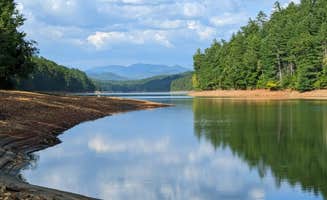
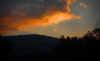
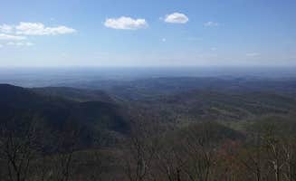
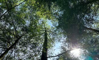
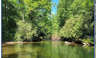
Dispersed camping near McCaysville, Georgia sits at the intersection of the Cherokee National Forest and Cohutta Wilderness where elevations range from 1,200 to 4,000 feet. The area features numerous creek-side locations along forest service roads with crystalline waterways that maintain cool temperatures even in summer months. Most primitive camping spots require 30-minute to 2-hour drives on gravel forest roads to reach the more remote locations.

What to do

Hiking to waterfalls: Follow the Goforth Creek trail from Goforth Creek Campground A for a less-traveled adventure. "The hike up the creek is really beautiful and a much less traveled trail than others in the area. I highly suggest going all the way to the end and taking a little dip. The water feels wonderful on a hot summer day," shares Asher K.

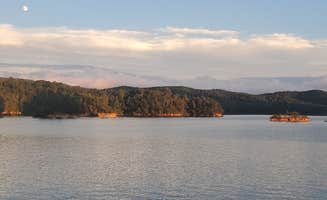
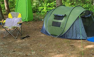
Fishing for bass: Set up at Panther Top Dispersed Site where the lake offers excellent fishing. "Lots of fish jumping and I caught a 1 pound large mouth bass on a silver spinning lure," reports Robert N. This site has established tent pads and fire rings just feet from the water.

Stargazing: Camp at Ball Field Dispersed Camping Area during new moon nights for extraordinary celestial views. "I searched on terrain maps for some of the best south facing skies for a great view of the belt of the milky way. Go here on a new moon night in the summer and you're sure to have a great night of uninterrupted beauty!" recommends Tyler J.

What campers like

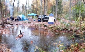
Creek access: Most free campsites near McCaysville feature proximity to water, with Lost Creek - Cherokee NF being particularly popular. "This campground is incredibly clean + quiet—and completely free. It's in the middle of nowhere (7 miles down a gravel forest road), surrounded by forest, with easy creek access (some sites are right beside the creek)," writes Brittany S.

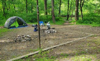
Privacy between sites: Many dispersed camping areas offer good separation between sites, especially during weekdays. "Each campsite has a concrete table, fire pit, and tent platform. Some have direct access to the creek. Great hikes around and good place to fish and hunt," notes Rayley P. about Lost Creek.

Sound of water: Falling asleep to the sound of rushing water is mentioned as a favorite feature. At Jack's River Falls Trail, Renee B. says: "Great group campsite not far from Jack's River Falls. We had a group of 10 that spread out over this little 'island' very easily. Fall asleep to the rushing waters of Jack's River!"

What you should know

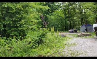
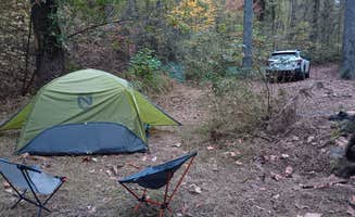
Limited facilities: Most dispersed sites have no amenities whatsoever. "This is primitive camping, so there are no facilities (no bathhouse, no power, no dump station, no trash, etc). It's all pack it in, pack it out. We had no service with Verizon," explains Steve V. about Big Creek Primitive Camping Area.

Road conditions: Forest service roads can be challenging, particularly after rain. "Gravel road, lots of rocks included, and dust but if you're not worried about your car do it! We had an SUV but I saw a handful of sedans that made it up," shares Gabrielle D. about accessing Ball Field Dispersed Area.

Cell service: Most sites have little to no connectivity. Scott E. notes about Lost Creek: "This little site was a great get away, except for the dogs. We chose a spot next to the creek. Was clear and flowing due to a lot of rain the few days before we arrived."

Tips for camping with families

Choose sites with swimming holes: Several creek-side sites have natural swimming areas perfect for children. At Conasauga River Camp, Grayce F. found: "Lovely little spot next to a very swimmable and warm crystal clear river - very popular with locals, and I imagine would be packed on weekends."

Consider hiking distances for kids: Some backcountry sites require substantial walking. "This is a tough trail but good for teens looking to challenge themselves in the back country. The views are amazing with rock falls. Camping is primitive as back country can be but worth the trek," advises Anna R. about Jack's River Falls Trail.

Watch for hunting seasons: Timing can impact the camping experience with families. "We apparently went during hunting season. Had to have been a dog sport. Too many dogs running around and barking throughout the night. Other than that we enjoyed our stay," reports Scott E.

Tips from RVers

Site leveling challenges: Many dispersed sites have uneven terrain. "The field is fairly sloped, so you want to have some shoring if you are in a trailer, roof top tent, or van," advises Steve V. about Ball Field Dispersed Camping Area.

Plan for self-sufficiency: With no hookups or facilities, RVers must bring everything needed. "We had 3 vehicles (two with rooftop tents and one with a small teardrop trailer) and we still had room for more set ups in the spot we set up in," reports Steve V. about Big Creek.

Consider vehicle clearance: While some sedans make it to certain sites, higher clearance is recommended. "Accessible easily from a 2WD just off of a long gravel road. There are about 5 or 6 good spots," notes Grayce F. about Conasauga River Camp, though most areas benefit from vehicles with better ground clearance.

Frequently Asked Questions

Where can I find dispersed camping sites near McCaysville, Georgia?

Several excellent dispersed camping options exist within driving distance of McCaysville. Ball Field Dispersed Camping Area offers a large field with multiple established fire rings and is popular with both hikers and overlanders, located near Lake Conasauga. For water lovers, Lake Santeetlah Dispersed provides free semi-developed campsites with some spots large enough for RVs, accessible by both vehicle and boat. The Cherokee National Forest also contains numerous dispersed sites just a short drive from McCaysville.

What amenities are available at dispersed camping areas in McCaysville?

Amenities at dispersed camping areas near McCaysville are minimal by design. Long Hungry Road Dispersed Campsites offers basic amenities including picnic tables, fire pit/grills, and level tent areas with beautiful lake views and access points for kayaks or canoes. Big Creek Primitive Camping Area provides spacious off-grid spots along a creek with room for multiple vehicles and setups, but no formal facilities. Most dispersed sites in the region lack water sources, restrooms, or garbage service, so campers should pack in all necessities and pack out all waste.

Are there any seasonal restrictions for dispersed camping in McCaysville?

Dispersed camping near McCaysville is generally accessible year-round, but conditions vary seasonally. Lost Creek - Cherokee NF is accessible via maintained gravel roads, though winter access may be challenging after heavy snowfall. Creekside Camp offers flat campsites next to a creek but may experience high water levels during spring runoff. Fall is particularly popular due to foliage, while summer offers warmer temperatures for water activities. Always check with the Chattahoochee-Oconee National Forest or Cherokee National Forest offices for current conditions and any temporary closures before heading out.