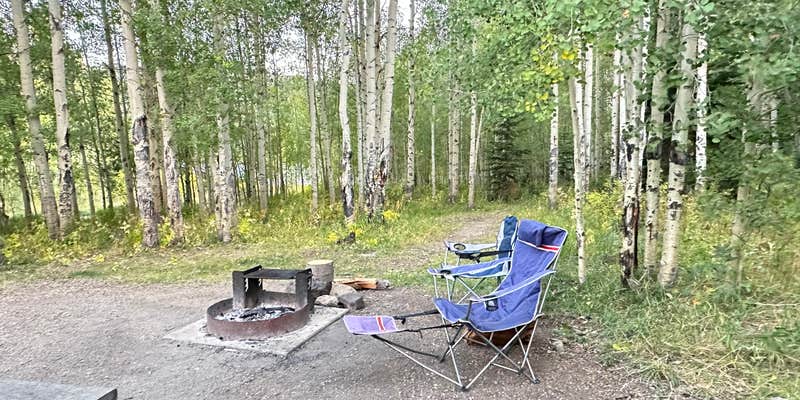
Chapman Reservoir, near Oak Creek, Colorado, is a unique campground that offers a mix of relaxation and outdoor fun. With sites that are spread out along the campground road, you’ll find options for both tent and RV camping, making it a flexible choice for different camping styles.
The reservoir is a highlight here, perfect for paddle boarding and fishing, with some campers raving about the clean restrooms and well-maintained facilities. One visitor mentioned, “The Frying Pan River became my soundtrack for the weekend,” emphasizing the serene atmosphere that many enjoy while soaking in the natural beauty around them.
For those who love to explore, there are great hiking trails nearby, and the area is known for its picturesque views and wildlife. Just keep in mind that the closest place to restock supplies is about an hour away, so plan accordingly. While some sites may lack shade, the overall vibe is friendly and welcoming, making it a great spot for families and groups looking to unwind and enjoy the great outdoors.
Description
ABOUT: This campground is located outside of Yampa, CO near the Dunckley Pass area off CTY Rd 8, (the Scenic Byway Flat Tops Trail) on Forest Service Road 940. Some sites offer a beautiful view of the reservoir and the Little Flat Tops. This is a perfect place to relax, or to take a scenic drive. The activities that you can enjoy here include fishing, some hiking and ATV riding nearby and wakeless boating. To access the reservoir, be prepared for a short hike. This campground does not allow ATV's to be driven through it, but does offer several ATV opportunities just outside the campground. Stop by the Yampa Ranger Station/Visitor center or the outside kiosk (if afterhours) for a brochure of the Flat Tops Trail Scenic By-Way as it includes some information on the areas highlights. AMENITIES: The campground has 1 vault toilet, and each campsite offers a picnic table, and a fire grate. PLEASE NOTE : This campground does not have electric, water or showers. (If seeking camping with potable water, please visit one of our other campgrounds. (Bear Lake Campground, Horseshoe Campground, Cold Springs Campground.) BOAT REGULATIONS : Electric trolling motors are allowed. Internal combustion engines are not allowed. (Combustion engines only allowed at Yamcolo Reservoir). FIRE RESTRICTIONS: Current as of August 3, We are still under a Stage 1 fire restriction. Camp fires are ONLY allowed in the permanent fire grates at the designated campsites/campgrounds. NO back country fires allowed, NO rock ring fires, (must use the permanent structure fire grates at the designated sites only) NO charcoal grills allowed. NO smoking outside allowed. PLEASE NOTE; THERE IS NO WATER AT THE CHAPMAN CAMPGROUND. COME PREPARED WITH EXTRA WATER TO PUT YOUR FIRE OUT COLD. DIRECTIONS FROM YAMPA: Take CTY Rd 17 west 5.5 miles to a "Y" intersection (CTY Rd 132). Stay left onto CTY Rd 132 and go 6.9 miles to the Chapman Reservoir sign (Forest Service Road 940). Turn left at sign onto Forest Service Road 940 and go 1.4 miles to the campground. NOTE: CTY Rd 132 changes to CTY Rd 8 after 4.2 miles.
RV Road Trip Guides


Map & DirectionsChapman Reservoir is located in Colorado near Oak Creek
Directions
In Yampa, CO, take County Rt. 17 west 5.5 miles to a "Y" intersection (County Rt. 132). Bear left onto Rt. 132 (gravel) and go 6.9 miles to Chapman Reservoir sign (Forest Rt. 940). Turn left at sign onto Rt. 940 (very steep and washboard) and go 1.4 miles to campground sign. Bear right into campground.
Coordinates
40.18600058 N
107.09100067 W
Connectivity
 T-MobileNo Coverage
- VerizonNo Coverage
- AT&TNo Coverage
Connectivity
- T-MobileNo Coverage
- VerizonNo Coverage
- AT&TNo Coverage
Access
- Drive-InPark next to your site
- Walk-InPark in a lot, walk to your site.
Site Types
- Tent Sites
- RV Sites
- Standard (Tent/RV)
- Group
Features
For Campers
- ADA Access
- Trash
- Picnic Table
- Firewood Available
- Phone Service
- Reservable
- Drinking Water
- Electric Hookups
- Toilets
- Alcohol
- Pets
- Fires
For Vehicles
- Big Rig Friendly
Drive Time
- 2 hrs 59 min from Denver, CO
- 3 hrs 1 min from Grand Junction, CO
- 3 hrs 9 min from Boulder, CO
- 3 hrs 37 min from Fort Collins, CO


