Within McArthur-Burney Falls Memorial State Park, this state-operated campground provides access to one of California's most distinctive waterfalls through two main camping areas. The Rim Camp loop offers 62 sites, while Pioneer Camp features both tent sites and cabin rentals, creating options for different camping styles.
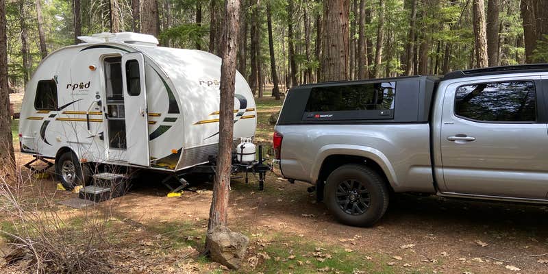
Highway noise affects sites closest to the road, particularly overnight when truck traffic peaks between midnight and 5:30 AM. "Otherwise it was quiet," notes Deb H., describing the atmosphere away from the highway side. Sites feature paved or dirt pads, with reviewers appreciating the pavement during rainy conditions. Most sites accommodate RVs up to 32 feet, though maneuvering larger rigs can be challenging due to the lack of pull-through sites.
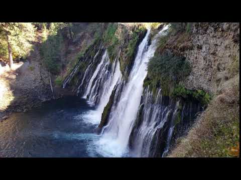
The 129-foot waterfall sits a 5-10 minute walk from camp via accessible trails. Patricia O. recommends watching for "black swifts by day, and big eared bats at night by the waterfall." Lake Britton offers swimming and boat rentals, though the walk requires significant elevation gain on return. Additional trails extend throughout the park, with the Pacific Crest Trail passing directly through the area.
Cell service remains nonexistent throughout the park, requiring trips to Burney for connectivity. The campground operates year-round at $35-70 per night, with reservations recommended during peak season when sites fill completely. Flush toilets and coin-operated showers serve both camping areas, though some reviewers noted issues with bear lockers. Aggressive squirrels pose food storage challenges due to visitor feeding.
For campers wanting additional space options, the nearby Memorial Cabin Area - Mcarthur-Burney Falls Memorial State Park provides rental cabins within the same park system.
Description
Pioneer Camp
Warning 1 Alert is In Effect
There is 1 alert for this campground. Camp safely!
Warning 1 Alert is In Effect
There is 1 alert for this campground. Camp safely!
Regarding Group Camp North and Group Camp South: 8 "STANDARD SIZE" vehicles are included in the price of the group camps. Extra vehicles will pay an additional fee per night. 8 "STANDARD SIZE" vehicles are allowed. However, if you bring an RV, it will limit the number of total vehicles, since an RV will take up approximately 5-8 standard size parking spaces. This means you may only be able to fit 1 RV and no other vehicles. If the vehicles are not able to fit in their respective parking areas, they will be required to park in overflow parking lots where space is available. If occupants choose to bring oversized vehicles (RVs, Boats, and Trailers), this may limit their ability to fit their 8 included vehicles in their respective parking area. Roadside and shoulder parking will not be permitted on Lake Road. Overnight parking at the Lake Parking Lot will not be permitted.
RV Road Trip Guides


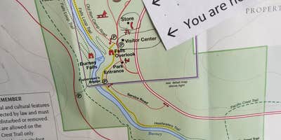
Map & DirectionsMcArthur-Burney Falls Memorial State Park Campground is located in California near Cassel
Directions
The park is northeast of Redding, 6 miles north of Highway 299 on Highway 89 near Burney.
Address
24898 Highway 89
Burney, CA 96013
Coordinates
41.016585 N
121.647631 W
Connectivity
 T-MobilePossible CoverageVerified by 13 usersLast on 6/20/26
 VerizonNo CoverageVerified by 10 usersLast on 6/20/26
 AT&TLTESome CoverageVerified by 1 userLast on 6/20/26
Connectivity
- T-MobilePossible CoverageVerified by 13 usersLast on 6/20/26
- VerizonNo CoverageVerified by 10 usersLast on 6/20/26
- AT&TLTESome CoverageVerified by 1 userLast on 6/20/26
Access
- Walk-InPark in a lot, walk to your site.
Site Types
- Tent Sites
- RV Sites
- Standard (Tent/RV)
- Group
- Cabins
- Tent Cabin
- Yurts
Features
For Campers
- Market
- Picnic Table
- Firewood Available
- Phone Service
- Reservable
- Electric Hookups
- Alcohol
- Pets
- Fires
For Vehicles
- Sewer Hookups
- Water Hookups
- 30 Amp Hookups
- 50 Amp Hookups
- Big Rig Friendly