This Army Corps of Engineers campground operates from May through September with sites ranging from $24-26 per night and accommodates RVs up to 45 feet. Located on Beaver Lake's shoreline, Lost Bridge South provides both drive-in access and primitive walk-in options, though campers report the access road can be rough. The campground features 42 sites built on sloped terrain with level asphalt pads for RVs and water and electric hookups available.
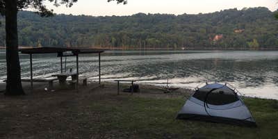
Most sites offer lake views, with higher-numbered sites like 42 and 46 providing the best water vistas. The campground sits in a forested setting where campers can drive directly to the lakefront for fishing and swimming access. Several visitors mention the clear water quality and note that bank fishing typically yields perch during summer months. A boat ramp provides easy launching, and the location offers convenient access to popular spots like Starkey Cove and Penitentiary Cove falls.
Facilities include restrooms, showers, and a dump station located up the road from the main camping area. Star L. notes "you can drive to lakefront free" for day use. The campground tends to stay busy during peak season, particularly March through October. Tent campers should be prepared for sloped ground, as level spots for pitching can be challenging to find on the hillside terrain.
Make reservations well in advance for waterfront sites, and consider visiting nearby Lost Bridge North for additional options in the same recreation area.
Description
Overview
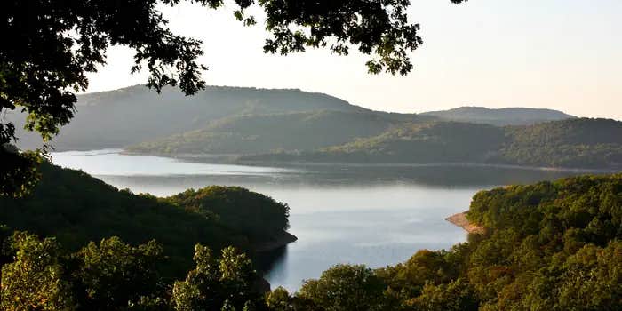
Lost Bridge South Campground sits along the vast shores of Beaver Lake in the Ozark Mountains of Northwest Arkansas, offering spacious and sunny campsites and an abundance of recreational activities.
Recreation
Fishing opportunities are plentiful near Lost Bridge South Campground. Beaver Lake has more than 28,000 surface acres of water, and anglers can try their luck at catching large and small-mouth bass, crappie, bream, white bass, stripers, and channel or spoon-bill catfish. Just below the dam, the cold waters of the upper White River provide the perfect habitat for pole-bending rainbow and record-sized German brown trout. Several trails snake throughout the Ozark Mountains, offering peaceful hiking, biking and wildlife viewing opportunities for visitors. Hunters will find game plentiful in northwest Arkansas. A mixture of hardwood and evergreen forest provides a good home to many different species of wildlife. While Beaver Lake is conveniently located near several population centers, within a short driving distance hunters can find remote areas filled with upland game such as deer, rabbits and squirrels. Many other sports and activities await campers, including boating, swimming, picnicking, scuba diving, water skiing, spelunking and sightseeing.
Facilities
Lost Bridge South Campground has large campsites with plenty of shade and room for activities, and is steps away from the lake shore. Fire rings, picnic areas, drinking water and flush toilets all make for a comfortable camping getaway.
Natural Features
Towering limestone bluffs, natural caves and a variety of trees and flowering shrubs surround Lost Bridge South Campground, making it an ideal retreat for outdoor enthusiasts. Beaver Lake and Dam, completed in 1966, was constructed in the White River Basin and boasts 449 miles of beautiful shoreline at the top of the conservation pool. Although the dam was originally built for flood control, hydroelectric power and public water supply, it has also created a popular recreational oasis.
Nearby Attractions
Several marinas are located around the lake, offering groceries, fuel, boat rentals and storage, fishing guides and camping supplies. Click here for more information.
Warning 1 Alert is In Effect
There is 1 alert for this campground. Camp safely!
Warning 1 Alert is In Effect
There is 1 alert for this campground. Camp safely!
Engaging in commercial business on US Army Corps of Engineers recreation areas is prohibited. This includes the delivery and setup of rental campers, rental boats or any other type of watercraft.
RV Road Trip Guides


Map & DirectionsLost Bridge South is located in Arkansas near Mountain Home
Directions
From Rogers, AR, take Highway 62 east for about 13 miles to Garfield. Turn right onto Highway 127 and continue for 6 miles. Turn right onto Highway 127 Spur and follow the signs into the park.
Address
12001 BUCKHORN CIRCLE
Garfield, AR 72732
Coordinates
36.3971361 N
93.9041111 W
Connectivity
 T-MobileNo CoverageVerified by 1 userLast on 7/16/26
 Verizon5GExcellent CoverageVerified by 1 user
 AT&T5GGood CoverageVerified by 4 usersLast on 7/16/26
Connectivity
- T-MobileNo CoverageVerified by 1 userLast on 7/16/26
- Verizon5GExcellent CoverageVerified by 1 user
- AT&T5GGood CoverageVerified by 4 usersLast on 7/16/26
Access
- Drive-InPark next to your site
- Walk-InPark in a lot, walk to your site.
- Boat-InSites accessible by watercraft.
Site Types
- Tent Sites
- RV Sites
- Standard (Tent/RV)
- Group
Features
For Campers
- Trash
- Picnic Table
- Phone Service
- Reservable
- Drinking Water
- Electric Hookups
- Toilets
- Alcohol
- Pets
- Fires
For Vehicles
- Sanitary Dump
- Water Hookups
- 50 Amp Hookups
- Big Rig Friendly
Drive Time
- 51 min from Fayetteville, AR
- 1 hr 25 min from Joplin, MO
- 1 hr 34 min from Fort Smith, AR
- 1 hr 36 min from Springfield, MO


