
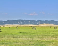
Within Bridger National Forest, Spring Creek Trailhead operates as a dispersed camping area managed by the US Forest Service. The site features several spots with established fire rings and picnic tables, including one location with a large picnic table. Hunters frequently use this area as a base camp, and some sites include meat poles for processing game.
Both the Greys River and Spring Creek flow near the camping area, providing water access for campers. The Spring Creek Falls trailhead begins here, though hikers should expect a river crossing at the two-mile mark on the five-mile route to the falls. Cell service reaches this location, and campers can bring pets and alcohol. For a more developed experience, Sacajawea offers traditional campground amenities seven miles east.
Description
The trail begins with a small ATV bridge across the creek from a dispersed campsite and parking area just on the west of Greys River, about 46 miles upriver from Alpine, Wyoming. It provides motorized access for 2 miles, then becomes a horse/hiking trail that connects to the Way Trail, or over the top to Sheep Pass. Spring Creek Falls is an attraction.
RV Road Trip Guides

Map & DirectionsSpring Creek Trailhead is located in Wyoming near Smoot
Directions
From the Town of Afton, Wyoming, head south on United States Highway 89 (US-89) for approximately 14 miles and turn left onto Smiths Fork Road/Forest Service Road 10072 (FS-10072). Continue on FS-10072 for 23.5 miles to the Tri-Basin Divide. Turn left (North) at the junction onto Greys River Labarge Road/FS-10138 and drive approximately 9.5 miles and turn left onto Spring Creek Road/FS-10242. Continue for less than a quarter mile and take the fist right onto FS-10242A for access to Spring Creek Trailhead. Approximate travel details from the Town of Afton: 48 miles, 69 minutes.
Coordinates
42.64838348 N
110.66474975 W
Connectivity
 T-MobileNo Coverage
- VerizonNo Coverage
- AT&TNo Coverage
Connectivity
- T-MobileNo Coverage
- VerizonNo Coverage
- AT&TNo Coverage
Access
- Drive-InPark next to your site
Site Types
- Tent Sites
- Group
- Equestrian
Features
For Campers
- Picnic Table
- Phone Service
- Alcohol
- Pets
- Fires
Drive Time
- 2 hrs 59 min from Logan, UT
- 3 hrs 5 min from Pocatello, ID
- 3 hrs 10 min from Idaho Falls, ID
- 3 hrs 43 min from Ogden, UT


