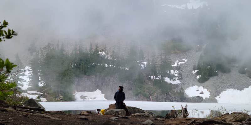
Fishing and high-alpine lake access draw campers to Melakwa Lake, a hike-in site within Snoqualmie National Forest at roughly 4,500 feet elevation. The trail up from Denny Creek Campground involves crossing large talus fields with a full pack, so the approach is genuinely strenuous. Ice can linger on the lake into July, and trout have been spotted actively jumping. Campfires are not permitted, and mosquitoes are heavy, particularly in summer. Pack bug protection and a fishing rod.
Description
This is a moderately-used trail connecting the Pratt Lake with Melakwa Lake within Alpine Lakes Wilderness.
Leaving Pratt Lake, traverse through forest and open slopes with great views 10 miles down the Pratt River Valley to the Middle Fork River. (Look for the transition from second growth forest to uncut forest in the valley below. That’s as far as the North Bend Timber Company was able to drag trees down to the 1930s-era railroad line below.) Pass by the north shore of Lower Tuscohatchie Lake to the junction of the Kaleetan Lake Trail 1010 at approximately .7 miles and stay right.
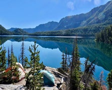
Beyond Tuscohatchie Lake, the trail continues for two miles with little elevation gain through old-growth forest with occasional views of the Pratt River valley and Kaleetan Peak. Continue for 2.3 miles, ascending gradually at first and ending in a series of switchbacks that climb to the junction with the Denny Creek Trail near Melakwa Lake. Melakwa Lake is beautiful, with clear green water and surrounding views of Bryant Peak from the east and Chair Peak from the northeast side.
https://www.fs.usda.gov/recarea/mbs/recreation/recarea/?recid=18004&actid=50
RV Road Trip Guides

Map & DirectionsMelakwa Lake is located in Washington near Snoqualmie Pass
Directions
From Seattle, head east on I-90 to exit 47 Denny Creek/Tinkham Road. At the top of the exit ramp, turn left and cross over the freeway. Go 0.2 miles and turn right at the stop sign onto Forest Road 58. The road crosses under the freeway, after driving 0.2 miles, turn left. Continue straight on for 2.9 miles and about a half mile past the Denny Creek Campground there is a large paved parking lot on the right that can accommodate about 60 cars. The trailhead can be accessed via a trail that begins near the bulletin board in the parking lot. The Denny Creek parking restrooms are closed, but the restrooms at Franklin Falls are available to hikers. There is ADA parking available nearer the Franklin Falls trailhead. Be sure to have a placard; parking patrols are on and will ticket violaters.
Coordinates
47.44876854 N
121.46875475 W
Connectivity
 T-MobileNo Coverage
 VerizonLTESome Coverage
- AT&TNo Coverage
Connectivity
- T-MobileNo Coverage
- VerizonLTESome Coverage
- AT&TNo Coverage
Access
- Hike-InBackcountry sites.
Site Types
- Tent Sites
Features
For Campers
- Drinking Water
- Toilets
- Alcohol
- Pets
Drive Time
- 56 min from Seattle, WA
- 1 hr 34 min from Olympia, WA
- 1 hr 35 min from Bremerton, WA
- 2 hrs 18 min from Wenatchee, WA


