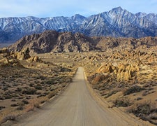
Open terrain defines Burbank Hills One Day Ride, a BLM-managed established campground sitting on camping near BLM Land — Fillmore Field Office in Garrison, Utah. The site has no tree cover to speak of, leaving campers exposed to wind and sun. Pets are not permitted. Nearby, Pruess Lake BLM Dispersed (UT-21) provides an alternative for those traveling with animals or wanting a different setting.
Description
Burbank Hills is open for motorized travel. Riders are encouraged to stay on existing roads and trails to prevent unneccesary impacts on the land.
RV Road Trip Guides

Map & DirectionsBurbank Hills One Day Ride is located in Utah near Garrison
Directions
South on I-15 to Nephi; southwest on SR-132 to Lynndyl; southwest on US-6 to Delta and west on US 50/6 for approximately 72 miles to the turnoff to the Cedar Pass Trailhead. It is 11 miles to the Cedar Pass Trailhead or 16 miles to the Red Pass Trailhead. The trail system can be accessed from the Snake Valley on the west side by traveling an additional 16 miles to the state border, exiting ssouth for approximately 8 miles on route 59 to Garrison and then traveling south for approximately 3 miles on route 21 to Pruess Lake trailhead or an additional 14 miles to the Morman Gap Resevoir Trailhead.
Coordinates
38.91313332 N
113.96989136 W
Connectivity
 T-MobileNo Coverage
- VerizonNo Coverage
- AT&TNo Coverage
Connectivity
- T-MobileNo Coverage
- VerizonNo Coverage
- AT&TNo Coverage
Access
Site Types
- Tent Sites
Features
Drive Time
- 2 hrs 43 min from St. George, UT
- 3 hrs 3 min from Provo, UT
- 3 hrs 34 min from Salt Lake City, UT
- 4 hrs 1 min from Ogden, UT

