Best Dispersed Camping near Baker, NV

The small town of Baker, Nevada serves as a gateway to numerous dispersed camping opportunities on surrounding public lands. BLM-managed areas like Gravel Pit, Great Basin Flats, and Sacramento Pass provide free or low-cost camping within minutes of town. Most sites accommodate both tent and RV camping with varying levels of accessibility. Sacramento Pass BLM Campground, located about 8 miles west of Baker on Highway 6, features designated sites with picnic tables, fire rings, and vault toilets. For those seeking more solitude, primitive dispersed sites can be found along Baker Creek Road and Snake Creek Road, with the single NF-589 site offering a secluded forest experience just outside Great Basin National Park boundaries.

Road conditions vary significantly throughout the region, with many sites requiring high-clearance vehicles. As one camper noted, "This OHV road is narrow and rough with decent sized rocks. There are very little opportunities to turn around and I would strongly recommend against entering with a two-wheel drive vehicle or a trailer." Most dispersed sites lack amenities, requiring visitors to pack in water and pack out waste. Cell service is spotty but available at some locations like Garnet Hill Camp, where one reviewer mentioned "ATT cell coverage was decent." Weather fluctuates dramatically with elevation, with snow possible even in late spring and fall, particularly at higher elevations near Wheeler Peak.

Campers consistently praise the area for its quiet atmosphere and proximity to Great Basin National Park attractions. Sacramento Pass serves as a popular alternative when park campgrounds fill up, with one visitor noting, "Great Basin was full, so went west on 6 about 8 miles and pulled into dispersed campground where there were some covered picnic tables at sites around a large central pond." The Gravel Pit site receives positive reviews for its convenience to Lehman Caves, though visitors should be aware it remains a working BLM site with occasional morning activity. Strawberry Creek Dispersed Camp earns high marks for accessibility, with one camper describing it as "quiet easy access—just what you want in a dispersed campsite."

Best Dispersed Sites Near Baker, Nevada (17)

    1. Sacramento Pass BLM Campground

    9 Reviews
    Great Basin National Park, NV
    12 miles

    "Not sure if this is what I understand to be dispersed camping, as it’s a first come first served campground with tables, fire rings and pit toilets, just no water."

    "Beautiful and clean dispersed camping. There are many different sites. Even has restrooms. The best sites are further back in the forest don't stop at the main section just off the road."

    2. Gravel Pit BLM Dispersed Campsite

    3 Reviews
    Baker, NV
    3 miles
    Website
    +1 (775) 289-1800

    "As the description said, it's a working gravel pit. ... and the BLM got to work at 8am the morning after I arrived. So, be aware of that."

    "A big flat gravel lot - found based on a dispersed camping map provided by the national park"

    3. Strawberry Creek Dispersed Camp

    3 Reviews
    Baker, NV
    8 miles
    Website
    +1 (775) 289-1800

    "Quiet easy access-just what you want in a dispersed campsite."

    "Easy to get into the park and easy to get situated. All dirty, with concrete pads for your RV or Trailer.

    Not a bad spot, felt safe and headed out the next day during our commute."

    4. Great Basin Flats

    1 Review
    Baker, NV
    3 miles

    "Large flat area just a few hundred yards off the road and five minutes from great basin Ranger station. The dirt road is a two track with a little rutting."

    5. Free single NF-589 Dispersed Campsite

    2 Reviews
    Baker, NV
    5 miles
    Website
    +1 (775) 289-1800

    "First off I'll start by saying the "Get directions" location on this app is incorrect AND the GPS will take you down a private, gated, dirt road to get there."

    8. Millard Desert Camp

    2 Reviews
    Garrison, UT
    22 miles

    "Pull off right next to freeway, large parking areas on both sides. More areas beyond fence on the north side. Stayed close to the entrance and didn't explore much."

    "The north side of the highway is a bit sandy and you might be cautious in 2wd cars. Nice views, pretty landscape and nothing much else."

    9. Garnet Hill Camp

    8 Reviews
    Ruth, NV
    48 miles

    "It it about 3 miles on a dirt road to the trailhead. As you are approaching the trailhead, there are spur roads with some good turnouts to park."

    "Lots of available dispersed spots for big groups/lots of people. Roads aren’t too bad, sort of bumpy & sandy. Heard coyotes at night which was cool."

    10. Marjum Pass Dispersed Camping

    2 Reviews
    Hinckley, UT
    42 miles

    "Dispersed camping and small pull-offs all throughout.

    Photos are of the Western slope pouring out of the canyon."

    "And has ~2000' of vertical rise and lies 4000' above the surrounding valley. Theres some good climbing in the canyon but there is room for plenty of development."

Show More
Showing results 1-10 of 17 campgrounds

2025 Detourist Giveaway

Presented byToyota Trucks

Review Campgrounds. Win Prizes.

Enter to Win


Dispersed Camping Reviews near Baker, NV

33 Reviews of 17 Baker Campgrounds


  • BoneMonkey ..The Dyrt PRO User
    Oct. 15, 2023

    Marjum Pass Dispersed Camping

    Open camping with great lines of sight

    Camped on the Western opening of Marjum Canyon. Drove through the canyon a few times. Dispersed camping and small pull-offs all throughout.

    Photos are of the Western slope pouring out of the canyon. As you exit the Canyon heading West, there are pull offs on both sides of the dirt road. Some areas may need high clearance vehicles to get over. There are small pull offs and dirt roads that low clearance vehicles can go over.

    Most surrounding land is BLM land.

    No Water

    No Shade

    No Wood

  • TThe Dyrt PRO User
    Jul. 27, 2024

    Free single NF-589 Dispersed Campsite

    Beautiful single site on a rough dirt road

    First off I'll start by saying the "Get directions" location on this app is incorrect AND the GPS will take you down a private, gated, dirt road to get there. Also, there is only ONE campsite on this road.

    When you set your GPS for this location the GPS will take you down Lehman Caves Road which is also highway 488 into the national park. About halfway down this road from the small town of Baker, you will be told turn left on Rowland Ranch Road. IGNORE THIS. Rowland Ranch Road is a gated dirt road on private property. Instead continue down Lehman Caves Road until you get to a left on Baker Creek Road. I have attached a picture of detailed instructions of this ^ in my review.

    Baker Creek Road is a maintained road within the national park boundaries but is hard pack gravel with some washboards along it. Just a little ways down Baker Creek Road, you will come to NF-589. This road starts as a Y split. Your first left is a foot path only with no camping signs in it. Directly behind it is the vehicle accessible entrance. Enter at your own risk! This OHV road is narrow and rough with decent sized rocks. There are very little opportunities to turn around and I would strongly recommend AGAINST entering with a two-wheel drive vehicle or a trailer. With that being said, I managed to squeeze down this road with my stock 2015 Toyota Tacoma towing a 12x6 enclosed trailer. My truck made it no problem without 4wd but I was at the limit of capability with my trailers ground clearance, width, and length. I also pre-scouted the singular campsite on this road with my off-road motorcycle to make sure nobody was there first. The only way for me to turn around with my trailer on NF-589 was to use the campsite I stayed in. Just into the entrance of the road you'll come across a downed tree across the road. Don't worry, somebody remade the road to the left going around it so continue on. About halfway towards the campsite you'll come across a small picket sign on the left side of the road that marks the national park boundaries. The campsite is on your left roughly another 500ft after that, just barely outside the national park boundary. There are some good wash outs almost a foot deep and 6-8in stones in the road. My 6-ft wide trailer, which is slightly wider than my truck, was touching trees on both sides for most of the way down.

    I'll say it again, there is only one campsite here. The GPS coordinates do not bring you to a campsite so follow my instructions instead. This campsite is tight as you first turn in but opens up in the middle about 20ft into it. It also has some flat open areas for tents just a few feet away from main area. The site is not level and on the slope of a hill. There are also some large rocks similar in size to the ones in the trail on the way in all through the site. My 4in levelers for my rooftop tent were not tall enough to counter this slope. I ended up having to use large boulders and back over them to level my truck so I could sleep. There's nothing here but a fire ring, that includes bathrooms of any kind. You are just in the middle of the woods.

    I would love it if people would stop having glass bottle parties around campfires. When did ruining fragile campsites become the new cool? I always try to leave a free campsite better than I found it. I spend time cleaning up other people's trash, rebuilding fallen fireplaces, and sweeping off cement patios when present. I would greatly appreciate it if you would do the same for others.

    Anyways, I was here for 2 nights. The views are slightly blocked by the trees but the trees are fairly short. If you can get above the trees like I could by sitting on the roof of my trailer when the sun went down, the views are actually stunning at this campsite. This campsite is almost walking distance to the Lehman Caves and just a few minutes drive to most other attractions here like the scenic drive to the Alpine Lakes at the base of Wheeler Peak. The campsite is completely silent but there is a home about a half mile through the woods to the North towards Lehman Caves Road so please be respectful with music volume even though it may feel as though you are in the middle of nowhere.

  • Jeff K.The Dyrt PRO User
    Jul. 2, 2023

    Old 93 BLM - Dispersed Camping

    Forest Service Down the Road

    About 10mi north of Ely. Map will take you to BLM off the highway. However, there are 4 forest service designated campgrounds on the road across the highway.

  • Dexter I.The Dyrt PRO User
    Jul. 29, 2022

    North Pinnacle Campsites — Great Basin National Park

    Spacious site in full view of road

    This camping location is listed as North Pinnacle on the National Geographic map of the park, other maps show the location but do not provide a name for this camping location. This is the third camping area along Great Basin National Park's Snake Creek Road. Located on the north side of the road, this campsite is not clearly marked like the others on the road, it is marked only by a small green tent sign. Campsite consist of a single very roomy campsite with plenty of room in the area for multiple tents. Parking is a small pull off from the road. At most you might get two cars in to the parking spot. The camping area is right along the road with no trees or other plants blocking the view from the road. Site has a picnic table, trash can and metal fire ring. This is a dry campground. This is the only campsite along the road to not have a vault toilet.

     Be warned, the information on the parks website is a bit misleading. Road is not for RV's or trailers. Just after you enter the park on Snake Creek Road a sign clearly indicated no RV's or trailers past the roads first pull out. Road is a narrow single lane road for almost all of its length. Camp site is just off a very dusty road, but road travel is slow with little traffic. No fee to use this site.

  • Peter I.The Dyrt PRO User
    Nov. 26, 2023

    Sacramento Pass BLM Campground

    Perfect

    Needed a place to overnight in my RTT, and this worked out great. Pulled in, was the only one there so had my choice of spots. Had a restful night and hit the road in the morning. No fuss! Not sure if this is what I understand to be dispersed camping, as it’s a first come first served campground with tables, fire rings and pit toilets, just no water.

  • Mike G.The Dyrt PRO User
    Jun. 19, 2023

    Garnet Hill Camp

    Lots of secluded space and cell coverage

    It it about 3 miles on a dirt road to the trailhead. As you are approaching the trailhead, there are spur roads with some good turnouts to park. There were 3 other cars in the area overnight, but I felt I had the place to myself with the junior and pine providing shelter. I am not sure how a take would fit, but there are some turnouts for a small trailer. ATT cell coverage was decent.

  • MThe Dyrt PRO User
    Oct. 16, 2024

    Sacramento Pass BLM Campground

    Clean, good alternative to Great Basin which tends to run FULL

    FREE! On the whole, avg., 3 stars. Not many developed BLM sites around.

    Great Basin was full, so went west on 6 about 8 miles and pulled into dispersed campground where there were some covered picnic tables at sites around a large central pond, following road up to equestrian corral and were several more sites. Stayed in#7 which was exposed, but the last one available so we took it. Free. Pit toilets are dirty but don't stink and trash has been emptied. Nice views to Wheeler Peak and out across UT

  • Amber The Dyrt PRO User
    Aug. 15, 2024

    Gravel Pit BLM Dispersed Campsite

    Great Spot if you're going to Lehman Caves

    I enjoyed camping here, and I could see it being a great spot for a large group. As the description said, it's a working gravel pit. ... and the BLM got to work at 8am the morning after I arrived. So, be aware of that. There is no shoulder on the highway, so you can't really pull over to check road or flood conditions before pulling into the pit. In my case it was totally fine, clear and flat, but I didn't really enjoy going in blind.

  • Alan B.The Dyrt PRO User
    Nov. 1, 2019

    Marjum Canyon - Dispersed

    Great Secluded Spot out in the Boonies!

    This is one of my favorite spots to camp out in the west desert!  Marjum Canyon lies just north of Sawtooth Mountain and the enormous cliff of Notch Peak which rises out of the valley floor 2000' feet!  Within Marjum Canyon itself there are also numerous single and multi-pitch climbing routes There are a couple of small pull-offs of the main canyon road that leads to very primitive campsites and even a hobbit hole that was walled in by a hermit that lived in the area for 20 years!  There are no amenities here so bring all the water you need and haul out all of your trash.  There is also no cell service out here so bring a spare tire, let someone know where you're going, and have an emergency beacon just in case!


Guide to Baker

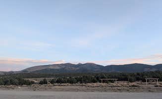
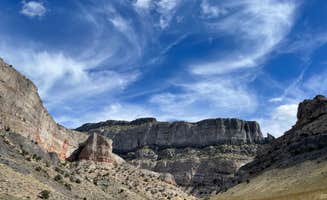
Dispersed camping near Baker, Nevada offers multiple free and low-cost options across BLM and Forest Service lands. This high-desert region sits at elevations between 5,300-8,000 feet with temperature swings of 30-40°F between day and night. Winter camping can encounter sub-freezing temperatures, while summer visitors should prepare for dry conditions with limited natural shade.

What to do

Collect garnets: Visit Garnet Hill Camp where visitors can hunt for gemstones. "Beautiful high desert scenery. Lots of available dispersed spots for big groups/lots of people. Roads aren't too bad, sort of bumpy & sandy. Heard coyotes at night which was cool," notes camper Truly W.

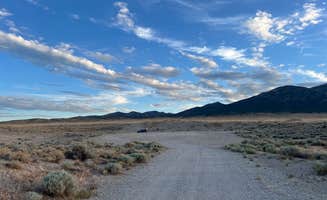
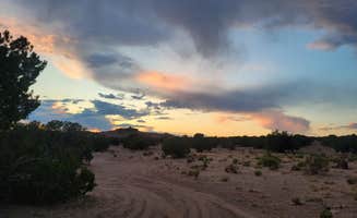
Stargazing opportunities: Clear desert skies provide excellent night viewing, particularly at higher elevation sites. At Millard Desert Camp, the remote location offers minimal light pollution. "This was a convenient stop as we drove through. As others have said, you can hear HW 50, but (at least in Nov) there was very little traffic," reports Mark H.

Winter camping: For cold-weather adventurers, some sites remain accessible year-round. One camper at Sacramento Pass notes, "We stayed in the second site for one night in late May. The CG is very clean and well maintained. Although, the CG is small, 8 total sites, 2 or 3 were available when we arrived at 3:30pm."

What campers like

Cellular connectivity: Some sites offer surprising connectivity for remote work. At Garnet Hill Camp, Marty K. advises, "About one thousand feet before the top of Garnet Hill, at a 90 degrees right hand turn, there are a number of good, level spots with excellent cell service on T-Mobile."

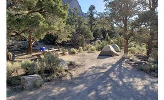
Covered picnic tables: At Sacramento Pass BLM Campground, Sarah M. appreciates that "Each site is an established site, with a covered picnic table & firepit. Each site is spaced out also. There's 2 bathrooms & a dumpster."

Camping near geological features: Several dispersed sites provide access to unique formations. At Marjum Pass, Alan B. reports it's "Home to one of the biggest cliffs in North America and you've probably never heard of it. Notch Peak is just to the south of the campground. And has ~2000' of vertical rise and lies 4000' above the surrounding valley."

What you should know

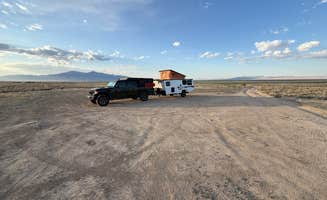
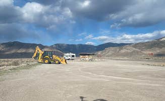
Working BLM sites: Some camping areas serve multiple purposes. At Gravel Pit BLM, Amber warns, "I enjoyed camping here, and I could see it being a great spot for a large group. As the description said, it's a working gravel pit... and the BLM got to work at 8am the morning after I arrived."

Road conditions vary dramatically: Many sites require appropriate vehicles. Rachel S. describes Gravel Pit as "A big flat gravel lot - found based on a dispersed camping map provided by the national park."

Limited turnaround space: Some forest roads restrict larger vehicles. At Garnet Hill Camp, Marty K. cautions, "I would not take a trailer or large motor home to the top of the hill. There are no good places for trailers (tents are ok) and the parking lot at the top is small."

Tips for camping with families

Forest camping with children: The single site on NF-589 offers wooded seclusion. Teri G. describes: "The views are slightly blocked by the trees but the trees are fairly short. If you can get above the trees like I could by sitting on the roof of my trailer when the sun went down, the views are actually stunning at this campsite."

Upper campground areas: At Sacramento Pass BLM Campground, Grant W. advises "Make sure you take the road up the hill out of the lower camp spots to the upper area. To this day this is one of my favorite spots. Worth staying a few days."

Pack extra water: No potable water exists at dispersed sites. At Marjum Pass, BoneMonkey warns campers about the basics: "No Water, No Shade, No Wood."

Tips from RVers

Level sites for larger vehicles: Several areas accommodate various RV sizes. At Strawberry Creek Dispersed Camp, Teresa A. describes it as "Quiet easy access-just what you want in a dispersed campsite."

Morning routines: Early risers may notice increased activity. At Garnet Hill Camp, one camper mentioned, "At 6:15am, a red truck did pass by the main dirt road and honked constantly for ~10 minutes, not sure if that's a regular occurrence or not, but pretty annoying."

Winter RV access: Snow doesn't always prevent camping. Alex H. reports from Garnet Hill Camp: "We loved this spot for an overnight. We drove our 25' RV up and found a perfect spot. It snowed over night and we woke up to a gorgeous sunrise. We navigated the gravel road just fine, even with light snow."

Frequently Asked Questions

Where can I find Baker dispersed camping areas?

Baker offers several dispersed camping opportunities in and around Great Basin National Park. Free single NF-589 Dispersed Campsite is located near Lehman Caves Road, though GPS directions may be inaccurate (there's only one campsite on this road). Great Basin Flats provides a large flat area just a few hundred yards off the road and five minutes from the Great Basin Ranger Station. Other nearby options include North Pinnacle Campsites along Snake Creek Road and various sites along Baker Creek Road. Most sites are accessible via dirt roads that may require high clearance vehicles in wet conditions.

What are the rules and regulations for dispersed camping in Baker?

Baker area dispersed camping follows standard BLM and National Forest regulations. At Sacramento Pass BLM Campground, camping is free and first-come, first-served with no reservations required. Old 93 BLM - Dispersed Camping provides access to public lands about 10 miles north of Ely. Generally, dispersed camping rules include: stay within designated areas, camp at least 200 feet from water sources, pack out all trash, use existing fire rings where available, and limit stays to 14 days in a 28-day period. Some areas may have seasonal fire restrictions. Always check with the local BLM office or Great Basin National Park for current regulations.

What amenities are available at Baker dispersed camping sites?

Baker dispersed camping sites typically offer minimal to no amenities. Marjum Pass Dispersed Camping features pull-offs on both sides of the dirt road but no developed facilities. Gravel Pit BLM Dispersed Campsite provides open space suitable for larger groups but is a working gravel pit with potential morning activity. Some exceptions exist - Sacramento Pass BLM Campground includes covered picnic tables and a central pond. Most dispersed sites have no running water, electricity, or toilets, so you'll need to be self-sufficient with water, waste disposal, and power. Cell service is typically limited, and you should plan to pack out all trash.