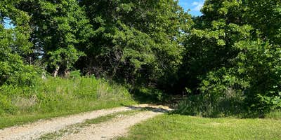
Gravel roads lead to dispersed camping sites scattered throughout this Missouri Department of Natural Resources conservation area near Laclede. Each site features a small gravel parking area with a fire ring, positioned close enough to the access road for easy setup but set back from plain view. Recent visitors report the main gravel road remains passable, though some areas near the creek become inaccessible during wet conditions.
The mowed grass areas and open gravel lots accommodate both car camping and tent setups. Campers typically find solitude here, with minimal overnight traffic and occasional morning visits from local law enforcement conducting routine patrols. For those exploring the broader region, campgrounds around Laclede provide additional overnight options within driving distance.
Description
Camping is permitted only in designated areas and is limited to 14 consecutive days in a 30-day period.
https://mdc.mo.gov/sites/default/files/2022-03/8422.pdf
This area fronts about two miles of Mussel Fork Creek. The area's rolling topography is typical of this region of the state which is generally marked by southward draining, closely spaced, sub-parallel streams resulting in a general pattern of narrow, linear ridges and wooded stream valleys. Historic conditions included plant communities that followed the elevational gradient with prairies occurring on the higher, drier sites blending with oak savannas on the ridges, and more densely forested areas along the steeper slopes. Low lands adjacent to Mussel Fork Creek were prone to flooding and included a complex pattern of wet prairie, marshes, oxbow lakes and river bank timber. These natural communities were home to a wide diversity of plants and animals. Management emphasis on the area is aimed toward enhancing the processes that result in a diverse prairie-savanna-woodland mosaic. Woodlands are a type of wooded community characterized as having a fairly open canopy cover, a poorly developed understory, and a diverse herbaceous layer of forbs, grasses, and sedges. Woodlands contain fire-tolerant trees, often with wide spreading crowns, and a diverse ground flora that may include species such as little bluestem, wild rye, bottle brush grass, blazing star, coneflower, and a variety of sedges. In northern Missouri, most woodland communities have been degraded due to extensive logging, fire suppression, overgrazing, and other disturbances. Woodland restoration practices used on the area include thinning and prescribed fire. Thinning removes some of the existing trees which provides a more open canopy and allows sunlight to reach the ground. Prescribed fire is essential to restoring a diverse woodland community as it suppresses small diameter woody vegetation, removes leaf and woody litter, and stimulates herbaceous plant growth resulting in a rich ground flora of forbs, grasses, and sedges. Well managed woodlands provide excellent habitat for wildlife. Species commonly associated with woodlands include white-tailed deer, wild turkey, bobwhite quail, red-headed woodpecker, Coopers' hawk, Indiana bat, three-toed box turtle, and eastern gray treefrog.
RV Road Trip Guides

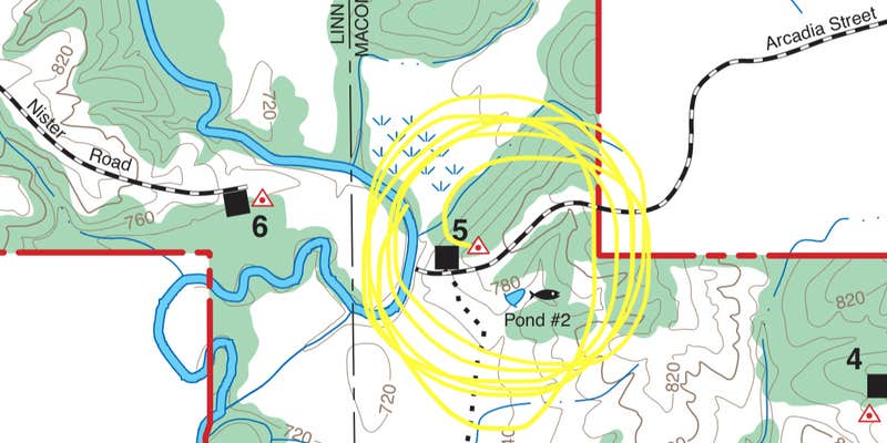
Map & DirectionsMussel Fork Conservation Area is located in Missouri near Laclede
Directions
From Brookfield, take Highway 36 east 10 miles to the area.
Coordinates
39.7290424 N
92.8548222 W
Connectivity
 T-MobileNo Coverage
 VerizonLTESome Coverage
- AT&TLTESome CoverageVerified by 1 userLast on 4/22/26
Connectivity
- T-MobileNo Coverage
- VerizonLTESome Coverage
- AT&TLTESome CoverageVerified by 1 userLast on 4/22/26
Access
- Drive-InPark next to your site
- Walk-InPark in a lot, walk to your site.
Site Types
- Tent Sites
- RV Sites
- Standard (Tent/RV)
- Dispersed
- Group
Features
For Campers
- ADA Access
- Phone Service
- WiFi
- Alcohol
- Pets
- Fires
For Vehicles
- Pull-Through Sites
FREE established camping
Enjoy camping on government land. Limited or no services at this camping area.
PERMIT might be REQUIRED
We curate permit requirements across the US for our PRO members. Try PRO to see if Mussel Fork Conservation Area needs a permit.
Drive Time
- 1 hr 18 min from Columbia, MO
- 1 hr 39 min from St. Joseph, MO
- 1 hr 44 min from Jefferson City, MO
- 1 hr 55 min from Kansas City, MO


