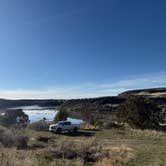
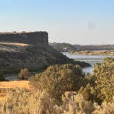
Free dispersed camping along the Snake River, this BLM site sits about eight miles from American Falls Dam via a network of dirt roads that require higher clearance vehicles. Multiple camping spots spread across different elevations, with some accessible to two-wheel drive vehicles near the top and others requiring four-wheel drive to reach closer to the water.
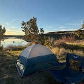
The sound of flowing water provides a natural soundtrack, as Robin B. notes: "You can hear the water, wonderful way to fall asleep!" Sagebrush dominates the high desert landscape, though established shade trees offer relief at several sites. Stone fire rings mark the most popular camping areas. Cell reception works well here, with multiple carriers reporting good signal strength. Traffic noise from nearby Highway 86 carries during the day but diminishes significantly at night.
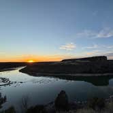
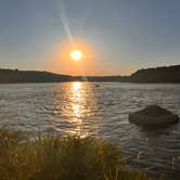
River access allows for bank fishing, and campers can walk down to cast directly into the Snake River. The area sits within camping near BLM Land — Pocatello Field Office, providing access to additional hiking trails with views across the desert terrain. American Falls Dam offers kayaking, paddleboarding, and additional fishing opportunities nearby. Pelicans frequent this stretch of river during certain seasons.
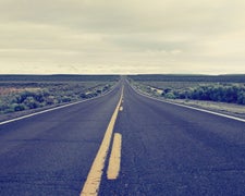
Road conditions vary significantly with weather and season. Deep ruts and channels develop along the access routes, making navigation challenging for some visitors. Leonard S. describes finding "a maze of twisted little passages" with "very deeply rutted roads." The road network includes multiple turns and intersections that can confuse first-time visitors.
Pack out all trash, as no facilities exist on-site. Bring bug spray during warmer months, and consider arriving with clear directions or GPS coordinates to avoid the confusing road system.
Description
Camping, fishing for trout and boating are the favorite activities along the Snake River from this semi-developed recreation site.
RV Road Trip Guides

Map & DirectionsSnake River Vista Recreation Site is located in Idaho near American Falls
Coordinates
42.70903999262389 N
112.94072463006334 W
Connectivity
 T-Mobile5GGood CoverageVerified by 3 usersLast on 7/30/26
 VerizonLTESome CoverageVerified by 1 userLast on 7/21/26
- AT&TLTESome CoverageVerified by 8 usersLast on 7/30/26
Connectivity
- T-Mobile5GGood CoverageVerified by 3 usersLast on 7/30/26
- VerizonLTESome CoverageVerified by 1 userLast on 7/21/26
- AT&TLTESome CoverageVerified by 8 usersLast on 7/30/26
Access
- Drive-InPark next to your site
- Walk-InPark in a lot, walk to your site.
- Boat-InSites accessible by watercraft.
Site Types
- Tent Sites
- RV Sites
- Standard (Tent/RV)
- Dispersed
Features
For Campers
- Phone Service
- Alcohol
- Pets
- Fires
DISPERSED CAMPING
Enjoy dispersed camping on government land and leave no trace. Pack in and pack out. No (or limited) services at this camping area. Permit may be required.
Drive Time
- 25 min from Pocatello, ID
- 59 min from Idaho Falls, ID
- 1 hr 11 min from Twin Falls, ID
- 1 hr 51 min from Logan, UT